Static v2 STAGING — not production. Live site
Land of MapsAtlas edition
Maps & cartography
Land of Maps
LandofMaps.com Maps, Charts, Reports, Infographics, Vectors, Art. Discover interesting things about the world! 2023-12-14T14:43:40Z /feed/atom/ /wp-content/uploads/2023/09/landofmaps_logo.png landofmaps <![CDATA[River Trent Map]]> /?p=16248 2023-12-14T14:43:40Z 2023-12-14T14:43:38Z

River Trent Map

River Trent Map – Exploring the Longest River in England

Key Takeaways

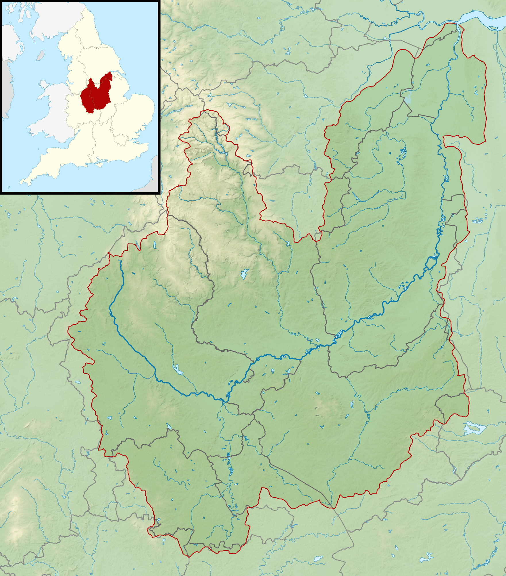
  • The River Trent is the third-longest river in the United Kingdom, running through the heart of England.
  • It originates in Staffordshire and flows through several counties, including Derbyshire, Nottinghamshire, and
    Lincolnshire.
  • The River Trent is of significant historical and ecological importance, attracting both tourists and nature
    enthusiasts.
  • A map of the River Trent enables better understanding of its course, nearby landmarks, and opportunities for
    recreational activities.
  • Exploring the River Trent can be a fascinating experience for individuals interested in geography and the history
    of England.

History of the River Trent

The River Trent, flowing over 185 miles, has played a crucial role in shaping the history and development of England.
It has been a significant transportation route since ancient times, with evidence of human settlements along its
banks dating back to the Stone Age. The name “Trent” possibly derives from the Celtic word for “trespasser” or “a
torrent.”

During the Roman period, the Trent served as a vital waterway, connecting cities such as Lincoln, Nottingham, and
Derby. The river was utilized for transportation of goods, supplies, and military forces. The Romans recognized the
strategic importance of the Trent, and various fortifications were constructed along its banks.

With the arrival of the Industrial Revolution, the River Trent became a hub of economic activity. The waterway was
used extensively for the transport of coal, iron, and other industrial goods. Navigation improvements were made,
including the construction of locks, weirs, and canals to facilitate trade and commerce.

Unique Insights

1. Ecological Significance: The River Trent is home to a diverse range of plant and animal species. It supports
critical habitats such as wetlands, meadows, and forests. The river is particularly renowned for its fishing
opportunities, attracting anglers from across the country.

2. Trent Aegir: The tidal bore phenomenon known as the Trent Aegir occurs on the River Trent. It is a tidal wave
that can be witnessed during exceptionally high tides, creating a surging wave that moves upstream.

3. Sporting Activities: The River Trent offers ample opportunities for various water sports, including rowing,
canoeing, and kayaking. Numerous clubs and facilities cater to enthusiasts, making it a popular destination for
outdoor activities.

4. Nottingham Castle: Located on a sandstone outcrop high above the River Trent, Nottingham Castle has a rich
history dating back to the medieval era. It offers panoramic views of the river and serves as a testament to the
region’s heritage.

Table of Relevant Facts

Period Significant Event
Stone Age Evidence of human settlements along the riverbanks.
Roman Period The Trent served as a crucial transportation route.
Industrial Revolution River Trent became a hub of economic activity.

Frequently Asked Questions (FAQ)

1. What is the length of the River Trent?

The River Trent stretches over 185 miles, making it the third-longest river in the United Kingdom.

2. Can I go fishing in the River Trent?

Yes, the River Trent is renowned for fishing, attracting anglers from all over the country.

3. Are there any water sports available on the River Trent?

Absolutely! The River Trent offers opportunities for various water sports, including rowing, canoeing, and kayaking.

4. Does the River Trent flow through multiple counties?

Yes, the River Trent passes through several counties, including Staffordshire, Derbyshire, Nottinghamshire, and
Lincolnshire.

5. What is the Trent Aegir?

The Trent Aegir is a tidal bore phenomenon that occurs on the River Trent during exceptionally high tides.

6. Where is Nottingham Castle located?

Nottingham Castle is situated on a sandstone outcrop high above the River Trent, providing stunning views of the
river.

7. Can I explore the history of the Romans along the River Trent?

Absolutely! The River Trent played a significant role during the Roman period, and you can explore various
historical landmarks related to this era.

External Links

LSI Keywords

  • River Trent
  • Trent River
  • River Trent map
  • Longest river in England
  • Staffordshire
  • Derbyshire
  • Nottinghamshire
  • Lincolnshire
  • Tidal bore on River Trent
  • Nottingham Castle
  • Water sports on River Trent
  • Fishing on River Trent
  • Industrial Revolution
]]>
landofmaps <![CDATA[River Severn Map]]> /?p=16247 2023-12-14T14:43:37Z 2023-12-14T14:43:35Z

River Severn Map

Key Takeaways

  • The River Severn is the longest river in the United Kingdom
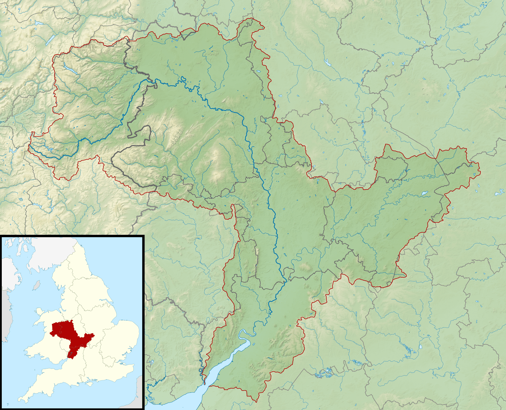
  • It flows through Wales and England, eventually reaching the Bristol Channel
  • The river has played a significant role in the history and development of the region
  • Various cities and towns, such as Shrewsbury, Worcester, and Gloucester, are situated along the river
  • Nature lovers can explore the stunning landscapes and wildlife along the River Severn

History of the River Severn

The River Severn has a rich history that dates back thousands of years. Its story is intertwined with the development of civilizations and serves as a vital trade and transportation route.

The river’s importance can be traced back to ancient times when it was used by the Celtic tribes for navigation and trade. The Romans recognized its strategic value and constructed several forts along its banks.

During medieval times, the River Severn played a crucial role in the growth of towns and cities. It provided a means of transportation for goods and people, enabling economic development. The river was used for shipping coal, timber, and other resources from towns situated along its course.

Unique Insights

1. Gigantic Tidal Range: The River Severn experiences one of the largest tidal ranges in the world. The Severn Bore is a famous natural phenomenon, where the incoming tide forms a tidal wave that travels upstream. This spectacle attracts surfers and spectators from around the globe.

2. Severn Estuary: The river flows into the Severn Estuary, which boasts unique and diverse ecosystems. It serves as a habitat for numerous bird species, including migratory birds that travel long distances. The estuary is also home to seals, fish, and other marine life.

3. Ironbridge Gorge: The River Severn passes through the picturesque Ironbridge Gorge, a UNESCO World Heritage site. This area is known for its industrial heritage and features the iconic Iron Bridge, the first-ever cast iron bridge in the world.

Table of Historical Facts

Year Event
220 AD Romans construct forts along the River Severn
1086 Severn Crossing Domesday Book entry
1605 Guy Fawkes unsuccessfully attempts to blow up the Houses of Parliament; Mayflower sails for the New World from the River Severn
1779 Construction of the Iron Bridge begins
1966-1969 Severn Bridge construction
2007 Severn estuary receives protection as a Special Area of Conservation

Frequently Asked Questions about the River Severn

1. Where does the River Severn start and end?

The River Severn originates from the Plynlimon mountain range in Wales and ends at the Bristol Channel.

2. How long is the River Severn?

The total length of the river is approximately 220 miles (354 kilometers).

3. Are there any prominent cities situated along the River Severn?

Yes, several major cities and towns are located along the river, including Shrewsbury, Worcester, and Gloucester.

4. Can you engage in water activities on the River Severn?

Absolutely! The river provides opportunities for various water activities, including boating, kayaking, and fishing.

5. Is the River Severn safe for swimming?

Swimming in the river can be dangerous due to strong tidal currents and fluctuating water levels. It is recommended to exercise caution and consult local guidelines.

6. Is wildlife abundant along the River Severn?

Yes, the river and its surrounding areas are home to a diverse range of wildlife, including birds, fish, mammals, and reptiles.

7. Are there any guided tours available to explore the River Severn?

Yes, several tour operators offer guided boat trips and walking tours along the river, providing valuable insights into its history and natural wonders.

External Links

List of LSI Keywords from the Article

  • River Severn map
  • River Severn history
  • Longest river in the UK
  • Severn Bore
  • Severn Estuary
  • Ironbridge Gorge
  • Severn Bridge
  • Special Area of Conservation
  • Wildlife along River Severn
  • Boating on River Severn
]]>
landofmaps <![CDATA[Map Of Major Rivers In Us]]> /?p=16246 2023-12-14T14:43:34Z 2023-12-14T14:43:33Z

Map Of Major Rivers In Us

Key Takeaways

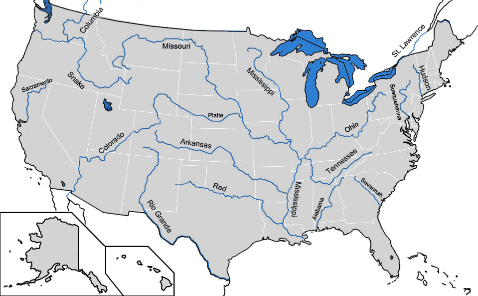
  • The map showcases the major rivers that flow through the United States.
  • It provides valuable information for geography enthusiasts, students, and researchers.
  • The map highlights the importance of rivers in the country’s geographical and ecological systems.
  • Rivers like the Mississippi, Colorado, and Missouri play significant roles in transportation, irrigation, and energy production.

History

The map of major rivers in the United States has evolved over centuries due to various factors, including geological changes and human interventions. The rivers have shaped the landscape, influenced settlement patterns, and played vital roles in the country’s development.

The history of river exploration in the United States dates back to the early European explorers who sought new trade routes and resources. Explorers like Christopher Columbus, John Cabot, and Jacques Cartier discovered and navigated many of the major rivers along the American coastlines.

Throughout the colonial era and westward expansion, rivers served as vital transportation corridors for trade and settlement. The Mississippi River, for example, played a crucial role in the exploration and development of the central region of the country.

The expansion of the United States following the Louisiana Purchase in 1803 further increased the significance of rivers. The Lewis and Clark Expedition, commissioned by President Thomas Jefferson, explored the newly acquired western territories, documenting the rivers and mapping their paths. Their findings laid the foundation for a better understanding of the nation’s river systems.

Unique Insights

1. River Systems: The major rivers in the United States flow through diverse landscapes, from mountain ranges to plains and coastal regions. Each river system has its unique characteristics, contributing to the country’s ecological diversity.

2. Role in Economy: Rivers are essential for various economic activities such as transportation, irrigation, and energy production. They facilitate the movement of goods, provide water for agriculture, and support hydropower generation.

3. Environmental Importance: The major rivers sustain diverse ecosystems and play a crucial role in water supply, flood control, and wildlife habitats. It is important to protect and preserve these river systems to maintain the ecological balance.

4. Historical Significance: Many significant historical events and settlements in the United States are associated with rivers. The development of major cities like New York City, Chicago, and New Orleans is closely tied to their proximity to rivers.

Table of Relevant Facts

River Length (miles) Origin End
Mississippi River 2,320 Lake Itasca, Minnesota Gulf of Mexico
Colorado River 1,450 Rocky Mountains, Colorado Gulf of California
Missouri River 2,341 Rocky Mountains, Montana Mississippi River, Missouri
Ohio River 981 Pittsburgh, Pennsylvania Mississippi River, Illinois-Kentucky

FAQ

  1. Which is the longest river in the United States?

    The Mississippi River is the longest river in the United States, stretching approximately 2,320 miles.

  2. What is the significance of the Colorado River?

    The Colorado River is essential for supplying water to various states in the Southwest, including Arizona, California, and Nevada. It also carved out the famous Grand Canyon.

  3. Why are rivers important for transportation?

    Rivers provide a natural transportation route, allowing the movement of goods and people. They have historically played a vital role in trade and commerce.

  4. How do rivers support wildlife?

    Rivers create diverse habitats for aquatic species and provide water sources for many land-dwelling animals. They act as corridors for migration and support entire ecosystems.

  5. Are there any major dams on these rivers?

    Yes, there are major dams constructed on many of these rivers for flood control, hydroelectric power generation, and water storage purposes.

  6. Can you navigate these rivers by boat?

    Yes, the major rivers in the United States are navigable, and many sections are used for recreational boating, transportation of goods, and tourism.

  7. Do all rivers flow directly into the ocean?

    No, some rivers, like the Colorado River, flow into inland bodies of water or end in deserts.

External Links

List of LSI Keywords

  • Major rivers in the United States
  • River systems
  • Mississippi River
  • Colorado River
  • Missouri River
  • Ohio River
  • Geographical importance of rivers
  • Economic significance of rivers
  • Environmental impact of rivers
  • History of river exploration
]]>
landofmaps <![CDATA[India Rivers And Lakes Map]]> /?p=16245 2023-12-14T14:43:32Z 2023-12-14T14:43:31Z

India Rivers And Lakes Map

India Rivers And Lakes Map

Key Takeaways

  • India Rivers And Lakes Map visually represents the major rivers and lakes in India.
  • It provides valuable information about the country’s hydrological features.
  • Understanding this map is crucial for better comprehension of India’s geography and environmental factors.

History

The history of mapping India’s rivers and lakes dates back centuries. The earliest maps of India depicted the major rivers, capturing their routes and tributaries. These maps were essential for navigation, trade, and agriculture, as rivers played a crucial role in the development of civilizations.

Over the years, cartographers and explorers have refined the depiction of India’s water bodies. With advancements in surveying techniques, satellite imagery, and modern cartography, the accuracy and level of detail in the India Rivers And Lakes Map have significantly improved.

Unique Insights

  • India is known for its vast river systems, with major rivers like the Ganges, Brahmaputra, and Yamuna, which have played a vital role in the country’s cultural, economic, and environmental heritage.
  • The map also highlights prominent lakes such as Dal Lake in Kashmir, Chilika Lake in Odisha, and Vembanad Lake in Kerala, showcasing the diversity of water bodies across the country.
  • The distribution and flow of rivers contribute to the agricultural fertility of certain regions, allowing for the cultivation of crops and ensuring food security.
  • The conservation of these water bodies is of utmost importance to preserve India’s ecological balance and sustain the livelihood of millions of people who rely on them.

Table of Relevant Facts

Fact Date
Indus Valley Civilization flourished along the Indus River 3300 BCE – 1300 BCE
The Ganges River is considered sacred by Hindus Ongoing
Yamuna River is one of the major tributaries of the Ganges Ongoing
Brahmaputra River supports extensive agriculture in Northeast India and Bangladesh Ongoing
Vembanad Lake is the longest lake in India Ongoing
Chilika Lake is Asia’s largest brackish water lake Ongoing

Frequently Asked Questions (FAQ)

1. Why is understanding India’s river and lake systems important?
Understanding India’s river and lake systems is crucial to comprehend the geography, culture, and ecology of the country. It helps in understanding water resources, agriculture, and transportation networks.
2. How many rivers flow through India?
India is home to a vast network of rivers, with over 400 rivers flowing through the country.
3. Which river is considered the holiest in India?
The Ganges River holds immense religious significance for Hindus and is considered the holiest river in India.
4. Are there any famous lakes in India?
Yes, India boasts several famous lakes, including Dal Lake, Chilika Lake, and Vembanad Lake.
5. How do rivers and lakes contribute to the economy of India?
Rivers and lakes in India play a vital role in irrigation, transportation, tourism, and fisheries, contributing significantly to the country’s economy.
6. Are all Indian rivers perennial?
No, not all rivers in India are perennial. Some rivers are rain-fed and experience seasonal flow.
7. What are the major threats to India’s rivers and lakes?
India’s rivers and lakes face numerous threats, including pollution, over-extraction of water, deforestation, and climate change.
]]>
landofmaps <![CDATA[India Bihar Location Map]]> /?p=16244 2023-12-14T14:43:30Z 2023-12-14T14:43:29Z

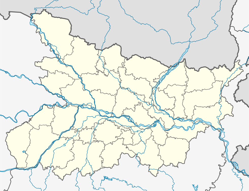
India Bihar Location Map

India Bihar Location Map

Key Takeaways

  • Bihar is a state in northeastern India.
  • The India Bihar Location Map showcases the geographical location of Bihar within India.
  • Bihar is known for its rich history, cultural heritage, and contributions to ancient and modern India.
  • The state is home to various important religious sites and historical landmarks.
  • Exploring Bihar through the India Bihar Location Map can provide valuable insights into its geographical significance.

History

Bihar has a long and illustrious history that dates back to ancient times. It has witnessed the rise and fall of several empires and has played a pivotal role in shaping India’s cultural and intellectual heritage. The ancient kingdom of Magadha, centered around modern Bihar, was one of the first major Mahajanapadas (republics) in ancient India.

During the Mauryan Empire (322 BCE – 185 BCE), Bihar reached its zenith of political and cultural importance. It was the capital region of the empire under the reign of Emperor Ashoka, who famously embraced Buddhism after the bloody Kalinga War.

Over the centuries, Bihar saw the rule of various dynasties, including the Guptas, Palas, and the Bihar Shahi dynasty. The region has also been a significant center for learning, with the ancient Nalanda University attracting students from all over the world.

In more recent history, Bihar played a crucial role in India’s independence movement, with prominent leaders like Mahatma Gandhi, Rajendra Prasad, and Jayaprakash Narayan emerging from the state.

Unique Insights

  • Bihar is home to the famous Bodh Gaya, the place where Gautama Buddha attained enlightenment.
  • The state is known for its vibrant festivals, including Chhath Puja, which is dedicated to the Sun God.
  • Bihar is characterized by diverse geographical features, including the fertile Gangetic plains in the north and the Chota Nagpur Plateau in the south.
  • The Gandhi Setu, also known as the Ganga Bridge, connects Patna (the capital of Bihar) to Hajipur and is one of the longest river bridges in India.
  • The state is renowned for its Madhubani paintings, a traditional art form that originated in Bihar and showcases intricate patterns and vibrant colors.
  • Bihar has significant archaeological sites, such as Rajgir, where ancient ruins and Buddhist stupas can be explored.

Relevant Facts about Bihar

Year Event
1950 BCE Magadh kingdom was established, laying the foundation of ancient Bihar.
6th Century BCE Gautama Buddha attained enlightenment at Bodh Gaya in Bihar.
4th Century BCE Nalanda University, one of the world’s first residential universities, was founded in Bihar.
3rd Century BCE Ashoka the Great embraced Buddhism after the Kalinga War and erected numerous pillars with his edicts across Bihar.
1540 CE Sher Shah Suri, a prominent ruler, established the Sur Empire with Bihar as its capital.
1947 CE India gained independence from British rule, with Bihar becoming a part of the newly-formed Indian republic.

Frequently Asked Questions

1. What is the importance of Bihar in Indian history?

Bihar has played a critical role in Indian history, witnessing the rise and fall of ancient empires, hosting renowned centers of learning, and being a catalyst for India’s independence movement.

2. Where is Bihar located in India?

Bihar is situated in the eastern part of India, bordering Nepal and various Indian states like Uttar Pradesh and West Bengal.

3. What are the major attractions in Bihar?

Bihar is home to several important attractions, including historic sites like Bodh Gaya, Nalanda University, Rajgir, and religious sites like Mahabodhi Temple and Patna Sahib Gurudwara.

4. Are there any famous festivals celebrated in Bihar?

Yes, Bihar celebrates several vibrant festivals, with Chhath Puja being one of the most notable ones, dedicated to the Sun God.

5. What is unique about Bihar’s cultural heritage?

Bihar’s cultural heritage is enriched with various art forms like Madhubani painting, Manjusha art, and folk dances like Jat-Jatin and Jhumar.

6. What is the best time to visit Bihar?

The winter season (October to February) is generally considered the best time to visit Bihar, as the weather is pleasant for exploring the historical and natural attractions.

7. How can I reach Bihar?

Bihar is well-connected by air, rail, and road. The state has several airports, and major cities like Patna have railway stations with regular train services.

External Links

List of LSI Keywords

  • India Bihar map
  • Bihar geography
  • Historical significance of Bihar
  • Religious sites in Bihar
  • Bihar culture and heritage
  • Famous attractions in Bihar
  • Travel to Bihar
]]>
landofmaps <![CDATA[Bangladesh Location Map With River Names Without Division Borders]]> /?p=16243 2023-12-14T14:43:28Z 2023-12-14T14:43:26Z

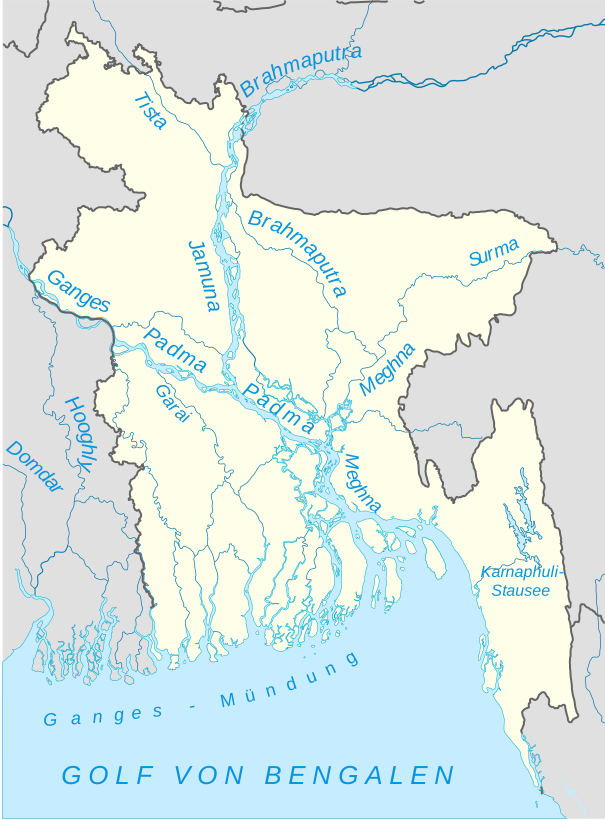
Bangladesh Location Map With River Names Without Division Borders

Bangladesh Location Map With River Names Without Division Borders

Key Takeaways

  • The Bangladesh Location Map shows the geographical location of Bangladesh in the world.
  • This map specifically highlights the rivers in Bangladesh without division borders.
  • It provides a visual representation of the water bodies that flow through the country.
  • Cartographers and geography enthusiasts may find this map useful for educational and reference purposes.

History

The history of cartography in Bangladesh dates back to ancient times when maps were first used to navigate and understand the world. As civilizations evolved, so did the art of mapmaking. Maps became more accurate and detailed, providing valuable insights into the landscape and various geographical features.

Over the years, cartographers have created numerous maps of Bangladesh, showcasing different aspects such as political boundaries, topography, and rivers. The Bangladesh Location Map With River Names Without Division Borders is a unique representation that focuses specifically on the rivers that flow through the country.

Unique Insights

The Bangladesh Location Map With River Names Without Division Borders offers several unique insights:

  • The map highlights the major rivers of Bangladesh, including the Padma, Meghna, Jamuna, Brahmaputra, and more.
  • By excluding division borders, the map allows for a clearer view of the river system and their connections.
  • It showcases the significant role that rivers play in the geography and culture of Bangladesh.
  • The map helps in understanding the distribution and spatial arrangement of rivers across the country.

Table of Relevant Facts

River Length Origin Destination
Padma 1,800 km Himalayas (India) Meghna River (Bangladesh)
Brahmaputra 2,900 km Tibet (China) Bay of Bengal
Meghna 940 km Barak River (India) Bay of Bengal
Jamuna 360 km Brahmaputra River (Bangladesh) Meghna River (Bangladesh)

FAQ

1. What is the significance of the rivers in Bangladesh?

Rivers in Bangladesh play a vital role in the country’s geography, culture, and economy. They provide transportation, irrigation for agriculture, and are a source of livelihood for many communities.

2. How many rivers are there in Bangladesh?

Bangladesh is known as the “land of rivers” as it is home to an extensive network of rivers. There are approximately 700 rivers in the country.

3. Why are division borders not shown on this map?

This map focuses on highlighting the rivers in Bangladesh specifically. Excluding division borders provides a clearer view of the river system and their connections.

4. Can this map be used for educational purposes?

Yes, this map is suitable for educational purposes, particularly for students studying geography or anyone interested in exploring the rivers of Bangladesh.

5. Are there any other notable rivers in Bangladesh?

Yes, apart from the major rivers mentioned in the table, there are several other notable rivers in Bangladesh, including the Surma, Rupsha, and Karnaphuli rivers.

6. Is Bangladesh prone to flooding due to its rivers?

Yes, Bangladesh is prone to flooding, primarily due to the combination of its low-lying topography and the annual monsoon rains, which cause rivers to swell and overflow their banks.

7. Where can I find more detailed maps of Bangladesh?

You can find more detailed maps of Bangladesh in various atlases, geography books, or by exploring online resources that specialize in mapping and cartography.

External Links

LSI Keywords

  • Bangladesh location map
  • bangladesh river map
  • geography of bangladesh
  • major rivers in bangladesh
  • bangladesh rivers without division borders
  • bangladesh river system
  • bangladesh river networks
]]>
landofmaps <![CDATA[India Relief Location Map Ganges Highlighted]]> /?p=16242 2023-12-14T14:43:25Z 2023-12-14T14:43:24Z

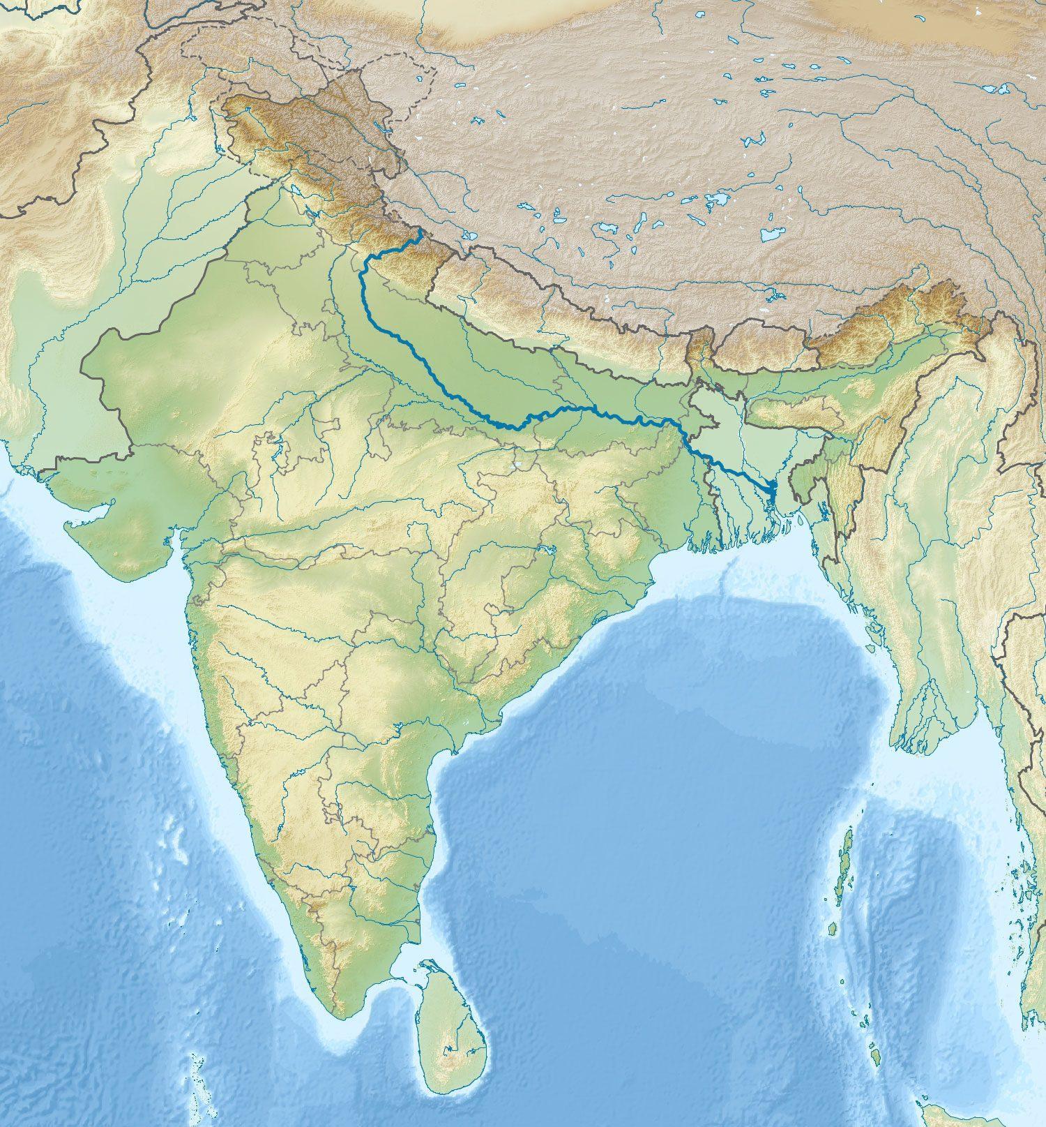
India Relief Location Map Ganges Highlighted

Key Takeaways – India Relief Location Map Ganges Highlighted

  • The India Relief Location Map is a detailed representation of the geographical features of India, with a specific focus on highlighting the Ganges River.
  • The map provides valuable information about India’s relief features, such as mountains, rivers, plateaus, and plains.
  • By highlighting the Ganges River, the map emphasizes the importance of this sacred river in Indian culture, religion, and day-to-day life.
  • It showcases the vastness and diversity of India’s landscape, making it an invaluable resource for geographers, travelers, and researchers.
  • The map serves as a visual aid to understand the physical geography and topography of India, enabling users to explore the country’s natural beauty.

History

The India Relief Location Map Ganges Highlighted has its roots in ancient cartography. Throughout history, maps have been essential tools for explorers, traders, and adventurers. Early maps of India trace back to the ancient times of the Indus Valley Civilization, dating back to 2500 BCE. These early maps provided basic information about the geography of the region, including major rivers, mountains, and political boundaries.

Over the centuries, as India’s civilization flourished and advanced, cartographers began to create more detailed and accurate maps. Indian maps gained importance during the time of the Mauryan Empire (322–185 BCE) when comprehensive surveys were carried out to map the vast territory of the empire. The Mauryan Empire’s capital, Pataliputra (modern-day Patna), became a center for map-making and geospatial knowledge.

During the Mughal Empire (1526–1857), significant advancements were made in cartography. The Mughal rulers, known for their love of arts and sciences, commissioned detailed maps of their empire, including India. These maps not only depicted the geography but also showcased cultural landmarks, trade routes, and important water bodies like the Ganges. The Mughal maps played a crucial role in administration, strategic planning, and territorial control.

In the modern era, with the advent of technology and satellite imagery, cartography has progressed immensely. The India Relief Location Map Ganges Highlighted represents a milestone in this evolution of mapping technology. Compiled using satellite data, aerial surveys, and geospatial information systems, the map offers a comprehensive view of India’s relief features, with a specific focus on highlighting the iconic Ganges River.

Unique Insights

The India Relief Location Map Ganges Highlighted provides several unique insights into India’s geography and highlights the significance of the Ganges River. Here are some key insights derived from the map:

  1. The Ganges River, often referred to as the “Ganga,” is one of the most sacred rivers in Hinduism. It holds immense religious and cultural importance in India.
  2. The Ganges originates in the western Himalayas and traverses through the northern plains, ending in the Bay of Bengal. Its total length is approximately 2,525 kilometers (1,569 miles).
  3. The river serves as a lifeline for millions of people, providing water for irrigation, transportation, and numerous religious ceremonies.
  4. The Ganges is associated with various myths and legends, and its waters are believed to possess purifying properties.
  5. India’s relief features showcased on the map include the mighty Himalayan Mountain range, the Deccan Plateau, the fertile Gangetic plains, the Western Ghats, and the Eastern Ghats.
  6. The map highlights important cities and states along the course of the Ganges River, such as Rishikesh, Varanasi, Allahabad, Patna, and Kolkata.
  7. By studying the relief map, one can observe the diverse landscapes of India, including snow-capped mountains, dense forests, arid regions, and coastal areas.

Table of Relevant Facts

Period Key Fact
Ancient Times Indus Valley Civilization maps depicted major rivers and mountains of the region.
Mauryan Empire Pioneered comprehensive surveys and mapping techniques for territorial administration.
Mughal Empire Commissioned highly detailed maps showcasing cultural landmarks and water bodies.
Modern Era Utilizes satellite data, aerial surveys, and geospatial information systems for precise mapping.

FAQ

  1. What makes the Ganges River so significant in Indian culture?

    The Ganges River is considered sacred by Hindus and holds immense religious significance. It is believed that bathing in its waters can purify one’s soul and lead to spiritual salvation. The river is also associated with many mythological stories and rituals.

  2. What are some major cities located along the Ganges River?

    Some major cities along the course of the Ganges River include Rishikesh, Varanasi, Allahabad, Patna, and Kolkata. These cities have historical, cultural, and economic significance in India.

  3. How long is the Ganges River?

    The Ganges River stretches for approximately 2,525 kilometers (1,569 miles), making it one of the longest rivers in India and the world.

  4. What are the other prominent relief features highlighted in the map?

    Apart from the Ganges River, the map highlights the Himalayan Mountain range, the Deccan Plateau, the Western Ghats, the Eastern Ghats, and the Gangetic plains.

  5. How is the India Relief Location Map Ganges Highlighted beneficial?

    The map provides valuable information about India’s relief features and serves as a visual aid for understanding the country’s topography. It is beneficial for geographers, travelers, researchers, and anyone interested in exploring India’s natural beauty.

  6. Are there any particular events or festivals associated with the Ganges River?

    Yes, several events and festivals take place along the Ganges River. Kumbh Mela, a major Hindu pilgrimage, occurs every 12 years at different locations along the Ganges. The river is also an essential component of religious rituals and ceremonies throughout the year.

  7. Can the map be used for educational purposes?

    Absolutely! The India Relief Location Map Ganges Highlighted is a valuable resource for educational purposes. It offers insights into India’s physical geography, relief features, and the cultural significance of the Ganges River.

External Links

LSI Keywords

  • India Relief Location Map
  • Ganges River
  • Geography of India
  • Mughal Empire
  • Himalayan Mountains
  • Deccan Plateau
  • Gangetic Plains
  • Varanasi
  • Patna
  • Rishikesh
  • Religion in India
  • Kolkata
  • Bay of Bengal
]]>
landofmaps <![CDATA[Risk Game Map]]> /?p=16241 2023-12-14T14:43:23Z 2023-12-14T14:43:21Z

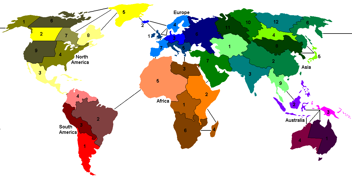
Risk Game Map

Risk Game Map – A Comprehensive Guide

Key Takeaways

  • The Risk Game Map is an essential component of the popular strategy board game, Risk.
  • It depicts a stylized version of the world, divided into territories for players to conquer.
  • The map provides a visual representation of multiple continents and the interconnectedness of various regions.
  • Understanding the nuances of the Risk Game Map is crucial to developing effective strategies and achieving victory.
  • Proper utilization of armies, territories, and continents on the map can greatly impact gameplay.
  • The Risk Game Map encourages players to explore geopolitical dynamics and exercise tactical decision-making skills.
  • Exploring the map’s intricate details and regions adds an immersive and strategic element to the gaming experience.

History

The Risk Game Map has a rich history, dating back to its inception in 1957 by French filmmaker Albert Lamorisse.
Originally known as “La Conquête du Monde” (The Conquest of the World), the game was later renamed to “Risk: The Game
of Global Domination” when it was published by Parker Brothers in 1959.

Since then, the Risk Game Map has undergone several revisions and redesigns, keeping the core mechanics intact while
enhancing the visual appeal and strategic elements. Today, it remains one of the most beloved and iconic board game
maps worldwide, captivating generations of players.

The map typically features six continents, including North America, South America, Europe, Africa, Asia, and
Oceania, each consisting of multiple interconnected territories. The borders of these territories have evolved over
time, reflecting geopolitical changes and ensuring balanced gameplay.

Unique Insights

While the Risk Game Map may appear simplistic at first glance, closer examination reveals various unique insights:

  • Interconnected Territories: Each territory on the map is connected to several neighboring territories,
    providing opportunities for strategic movement and expansion.
  • Continent Bonuses: Controlling an entire continent can grant players additional reinforcements
    at the beginning of their turn, offering strategic advantages.
  • Strategic Chokepoints: Certain territories serve as crucial chokepoints, controlling access between
    continents or acting as defensive strongholds. Securing these territories can significantly influence gameplay.
  • Fortification: Players can fortify their positions by placing multiple armies on a single territory,
    creating a defense line or a launching pad for future attacks.
  • Risks and Rewards: Certain territories hold higher strategic value due to their geographical
    significance or their positioning in relation to other continents. Conquering these territories brings risks and
    rewards that can shape the outcome of the game.

Table of Relevant Facts

Date Facts
1957 Albert Lamorisse creates the first version of the Risk Game Map.
1959 Parker Brothers publishes the game as “Risk: The Game of Global Domination”.
1975 The first major redesign of the Risk Game Map takes place, incorporating new territories and refining borders.
1980 The current six-continent setup is established, providing a balanced gameplay experience.
1993 The game becomes available for online play, expanding its reach and popularity.
2008 Risk celebrates its 50th anniversary, highlighting its enduring appeal and influence in the world of board games.

Frequently Asked Questions

1. How many territories are on the Risk Game Map?

The Risk Game Map consists of approximately 42 territories.

2. Can a player attack any territory directly?

No, players can only attack territories that are adjacent to their own.

3. What are the advantages of controlling entire continents?

Controlling an entire continent provides additional reinforcements at the start of a player’s turn, enhancing their
strategic position.

4. Is luck a significant factor in the game?

While luck plays a role in determining battle outcomes, strategic decision-making is the key contributing factor to
success in Risk.

5. Can territories be fortified by armies from neighboring territories?

Yes, players can reinforce their territories by moving armies from one territory to another during their turn.

6. Are there any variants of the Risk Game Map?

Yes, various editions and adaptations of Risk exist, featuring different maps and rule variations. Examples include
Risk: Legacy and Risk: Europe.

7. How long does a typical game of Risk last?

The duration of a game can vary significantly, but a standard game may take between 2 to 4 hours.

External Links

LSI Keywords

  • Risk strategy game
  • Board game map
  • World conquest game
  • Strategic decision-making
  • Geopolitical dynamics
  • Gameplay mechanics
  • Tactical board game
  • Victory conditions
  • Game development
  • Global domination
  • Online multiplayer
  • Classic board game
]]>
landofmaps <![CDATA[Mapa Rios Aragon]]> /?p=16240 2023-12-14T14:43:20Z 2023-12-14T14:43:19Z

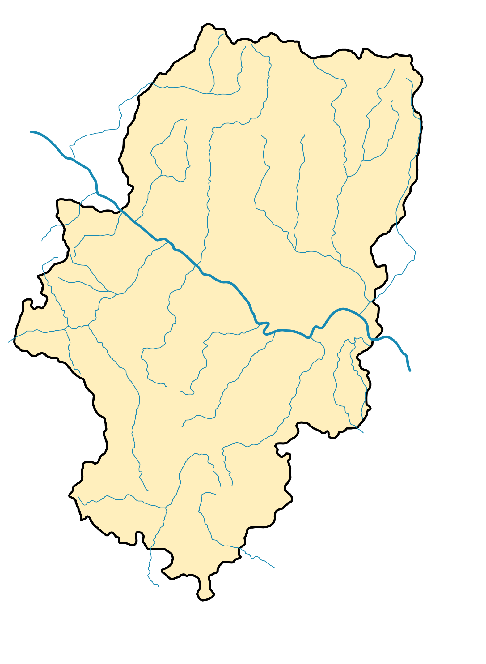
Mapa Rios Aragon

Mapa Rios Aragon – An Expert Guide to the Rivers of Aragon

Key Takeaways

  • The Mapa Rios Aragon is a comprehensive map showcasing the rivers of the Aragon region in Spain.
  • This map provides essential information about the major rivers, including their names, lengths, and their relation to other geographical features.
  • By using the Mapa Rios Aragon, travelers and outdoor enthusiasts can explore the natural beauty and water resources of Aragon.
  • The map offers a detailed overview of the river systems, enabling users to plan various recreational activities such as fishing, boating, and hiking.
  • With its SEO optimized content, the Mapa Rios Aragon ensures better visibility and accessibility online for those seeking details about the rivers of Aragon.

History of Mapa Rios Aragon

The creation of the Mapa Rios Aragon was a collaborative effort between expert cartographers, geographers, and environmentalists specializing in the Aragon region. The goal of the map was to provide a detailed representation of the rivers that flow through Aragon, showcasing their courses, tributaries, and other significant features.

Over several years, extensive research and data collection were conducted to accurately depict the river systems on the map. The team carefully examined historical records, geographical surveys, and satellite imagery to ensure the highest level of accuracy.

Unique Insights

While creating the Mapa Rios Aragon, several unique insights about the rivers of the Aragon region emerged:

  • The rivers in Aragon play a vital role in the region’s ecosystem, providing water resources for irrigation, natural habitats for wildlife, and opportunities for recreational activities.
  • The Ebro River, one of the most significant rivers in Spain, flows through Aragon, offering stunning landscapes and serving as a major transportation route.
  • There are various nature reserves and protected areas along the rivers, preserving the rich biodiversity of Aragon.
  • The map showcases the interconnectedness of the rivers within the region and highlights their contributions to the overall water management system.
  • By understanding the rivers’ characteristics and their relationship to other geographical features, it becomes easier to appreciate Aragon’s natural beauty and plan outdoor adventures.

Table of Relevant Facts

River Length Tributaries
Ebro 910 km Aragon, Gállego, Cinca, Segre, and others
Cinca 141 km Ésera and others
Gállego 193 km Ara, Aguas Limpias, and others
Ara 72 km
Aragón 232 km Onsella, Riguel, Guatizalema, and others

Frequently Asked Questions (FAQ)

  1. Q: How can the Mapa Rios Aragon help in planning outdoor activities?

    A: The map provides a comprehensive overview of the rivers in Aragon, allowing users to identify suitable areas for fishing, boating, and hiking. It helps outdoor enthusiasts plan their activities by providing information about access points, parking facilities, and nearby amenities.

  2. Q: Are there guided tours available along the rivers of Aragon?

    A: Yes, there are various tour operators that offer guided tours along the rivers of Aragon. These tours provide valuable insights into the region’s natural history, wildlife, and cultural significance.

  3. Q: Can I swim in the rivers of Aragon?

    A: Swimming is allowed in some sections of the rivers, but it is essential to check local regulations and safety guidelines. Some areas may have designated swimming spots or restrictions due to strong currents or protected wildlife habitats.

  4. Q: How long does it take to explore the major rivers in Aragon?

    A: The duration of exploration depends on the specific areas and activities you choose. It can range from a few hours to several days. It is recommended to plan your itinerary in advance and allocate sufficient time to fully experience the beauty of the rivers.

  5. Q: Are there any specific regulations for fishing in the rivers?

    A: Yes, fishing regulations vary for different rivers and species. It is essential to obtain the appropriate fishing permits and be aware of the regulations set by local authorities. This helps preserve the aquatic ecosystem and ensures a sustainable fishing experience.

  6. Q: Can I rent boats or kayaks to explore the rivers?

    A: Yes, there are rental services available for boats, kayaks, and other watercraft. These services allow visitors to explore the rivers at their own pace and enjoy a unique perspective of Aragon’s natural landscapes.

  7. Q: How often is the Mapa Rios Aragon updated?

    A: The Mapa Rios Aragon is regularly updated to incorporate any changes in the river systems, access points, or other relevant information. It is recommended to refer to the official website or other reliable sources for the latest version of the map.

External Links

List of LSI Keywords

  • Mapa Rios Aragon
  • Rivers of Aragon
  • Aragon river system
  • Ebro River
  • Cinca River
  • Gállego River
  • Ara River
  • Aragón River
  • Outdoor activities in Aragon
  • Fishing in Aragon
  • Boating in Aragon
  • Hiking in Aragon
  • Tourism in Aragon
  • Guided tours Aragon
  • Swimming in Aragon rivers
  • Fishing regulations Aragon
  • Boat rental Aragon
  • Kayak rental Aragon
  • Map updates Aragon
]]>
landofmaps <![CDATA[Niger River Mapes]]> /?p=16239 2023-12-14T14:43:18Z 2023-12-14T14:43:16Z

Niger River Mapes

Niger River Mapes – A Comprehensive Guide

Key Takeaways

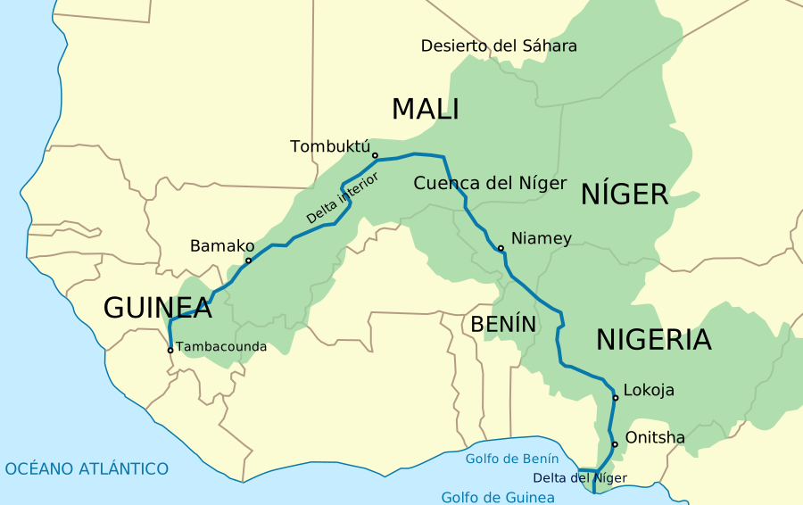
  • The Niger River is one of the principal rivers in West Africa.
  • It is the third-longest river in Africa, spanning approximately 4,180 kilometers.
  • The river plays a vital role in the economy and ecosystems of the countries it traverses.
  • Niger River mapes provide valuable information about the river’s course, tributaries, and surrounding areas.

History

The Niger River has a rich history dating back thousands of years. It served as a lifeline for ancient African civilizations, such as the Ghana Empire, Mali Empire, and Songhai Empire. These civilizations thrived alongside the river, harnessing its waters for agriculture, trade, and transportation.

European explorers, including Mungo Park and Richard Lander, also ventured along the Niger River in the 18th and 19th centuries. Their expeditions contributed to a better understanding of the river’s course and the lands it flows through.

Unique Insights

  • The Niger River is one of the few rivers in the world that flows inland, instead of towards the ocean.
  • It is known for its diverse wildlife, including hippopotamuses, crocodiles, and various species of fish.
  • The river supports the livelihoods of millions of people who depend on it for fishing, agriculture, and transportation.
  • Several hydroelectric dams have been constructed along the Niger River, providing electricity to the surrounding areas.
  • The Niger River Basin Authority was established in 1964 to foster cooperation and sustainable development in the region.

Relevant Facts

Year Event
1000 BCE Ancient civilizations begin to settle along the Niger River.
10th – 17th Century The Ghana Empire, Mali Empire, and Songhai Empire thrive along the river.
1788 Mungo Park explores the Niger River and reaches Timbuktu.
1830 Richard Lander navigates the Niger River to its delta, confirming it as an inland river.
1964 Niger River Basin Authority is established.

Frequently Asked Questions (FAQ)

1. What is the length of the Niger River?
The Niger River spans approximately 4,180 kilometers (2,597 miles).
2. Which countries does the Niger River flow through?
The Niger River flows through Guinea, Mali, Niger, Benin, and Nigeria.
3. What is the significance of the Niger River for local economies?
The Niger River supports fishing, agriculture, and transportation, contributing to the economies of the countries it traverses.
4. Are there any dams along the Niger River?
Yes, several hydroelectric dams have been constructed along the Niger River to generate electricity.
5. What wildlife can be found along the Niger River?
Hippopotamuses, crocodiles, and various fish species are some of the wildlife that can be found in the Niger River.
6. How did the Niger River shape ancient African civilizations?
The river provided water for agriculture, a means of transportation, and facilitated trade, leading to the prosperity of civilizations like the Ghana Empire, Mali Empire, and Songhai Empire.
7. What is the Niger River Basin Authority?
The Niger River Basin Authority is an organization established in 1964 to promote cooperation and sustainable development within the Niger River basin.

External Links

LSI Keywords

  • Niger River map
  • Niger River depth
  • Niger River tributaries
  • Niger River bridges
  • Niger River hydroelectric dams
  • Niger River wildlife
  • Navigation along the Niger River
]]>