Static v2 STAGING — not production. Live site
Land of MapsAtlas edition
Maps & cartography
Land of Maps
17th Century – LandofMaps.com https://landofmaps.com Maps, Charts, Reports, Infographics, Vectors, Art. Discover interesting things about the world! Sun, 08 Oct 2023 14:43:13 +0000 en-US hourly 1 /wp-content/uploads/2023/09/landofmaps_logo.png 17th Century – LandofMaps.com https://landofmaps.com 32 32 17Th Century India Map From Bertius Atlas Maps /17th-century-india-map-from-bertius-atlas-maps/ Sun, 08 Oct 2023 14:43:12 +0000 /?p=11324

17Th Century India Map From Bertius Atlas Maps

Key Takeaways

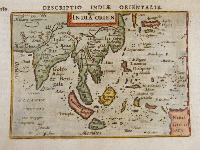
  • The 17th Century India Map from Bertius Atlas Maps provides a unique glimpse into the geopolitical landscape of India during that time.
  • This historical map showcases the significant cities, trade routes, and political boundaries of India during the 17th century.
  • The map represents a valuable resource for historians, cartographers, and anyone interested in exploring the rich history of India.
  • By examining this map, one can gain insights into the colonial powers, cultural diversity, and economic significance of India during that era.
  • It serves as a testament to the cartographic skills and artistic talents of the mapmakers of that period.

History

The Significance of 17th Century India Map

The 17th Century India Map from Bertius Atlas Maps holds great historical value as it reflects the complex geopolitical landscape of India during a time of significant cultural, political, and economic change. This map provides crucial insights into the colonial powers that were shaping the region, the diverse culture and languages present, as well as the trade routes and important cities that played a pivotal role in India’s history.

The Map’s Origin

The 17th Century India Map is a part of the Bertius Atlas Maps collection, which was created by famous French cartographer Petrus Bertius. Published in 1616, this particular map was included in his atlas titled “Tabularum Geographicarum Contractarum.” Bertius, known for his meticulous attention to detail and accuracy, incorporated information from a variety of sources to create this comprehensive depiction of India.

Geographical Features and Political Boundaries

The map displays various geographical features, such as rivers, mountains, forests, and coastlines, providing a detailed representation of the Indian subcontinent. It also showcases the political boundaries of different regions and kingdoms within India during the 17th century, illustrating the territorial divisions that existed during that time.

Trade Routes and City Markers

One of the notable features of this map is the depiction of significant trade routes, which were crucial for the economic prosperity of the region. Traders used these routes to transport goods and establish connections between different parts of India. The map also highlights important cities and towns, serving as centers of political administration, trade, and cultural exchange.

Artistic Style and Aesthetics

The 17th Century India Map demonstrates the artistic skills of the cartographers of that period. The map incorporates intricate illustrations, including decorative elements such as compass roses, sea monsters, and sailing ships. These ornamental additions not only enhance the visual appeal of the map but also provide valuable insights into the prevailing cultural and artistic styles of the time.

Unique Insights

Colonial Powers in India

The map reveals the presence of various European colonial powers operating in India during the 17th century. It shows the dominions of the Portuguese, the Dutch, the British, and the French, highlighting their respective territories and trading posts. This serves as a significant reminder of the intense competition between colonial powers for control over trade and resources in India during that time.

Cultural Diversity

India has always been known for its rich cultural diversity, and the map demonstrates this through the inclusion of numerous regional kingdoms, each with its distinct customs, languages, and traditions. This portrayal showcases the extensive cultural tapestry that existed in India during the 17th century.

Economic Significance

The trade routes depicted on the map highlight the economic importance of India during the 17th century. India served as a major hub for international trade, connecting Europe, Asia, and Africa. The presence of trade routes demonstrates India’s status as a vital player in the global economy and emphasizes the abundance of valuable resources available in the region.

Table of Relevant Facts

Fact Description
European Colonial Powers The map reveals the dominions and trading posts of the Portuguese, Dutch, British, and French in India.
Trade Routes The map displays important trade routes that connected India with other parts of the world.
Political Boundaries The map showcases the territorial divisions and kingdoms present in India during the 17th century.
Geographical Features The map illustrates major rivers, mountains, forests, and coastlines of the Indian subcontinent.
City Markers Significant cities and towns are marked on the map, displaying their importance in trade and political administration.

FAQ

1. What is the significance of the 17th Century India Map?

The 17th Century India Map provides valuable insights into the geopolitical, cultural, and economic aspects of India during that period. It showcases colonial powers, cultural diversity, trade routes, and political divisions.

2. Who created the 17th Century India Map?

The map was created by Petrus Bertius, a renowned French cartographer, and published as part of his atlas titled “Tabularum Geographicarum Contractarum” in 1616.

3. What does the map reveal about the European colonial powers?

The map highlights the territories and trading posts of Portuguese, Dutch, British, and French colonial powers in India during the 17th century, showcasing their presence and influence.

4. How does the map depict cultural diversity?

The map showcases various regional kingdoms, each with its distinct customs, languages, and traditions, providing a glimpse into the cultural diversity that existed in India during that time.

5. What does the map tell us about trade routes?

The map displays important trade routes that were pivotal for India’s economic prosperity and facilitated the exchange of goods between different regions of India and the rest of the world.

6. What artistic elements are present in the map?

The 17th Century India Map incorporates intricate illustrations, compass roses, sea monsters, and sailing ships, reflecting the artistic style and aesthetics of the cartographers of that era.

7. How can the map be utilized by historians and cartographers?

The map serves as a valuable resource for historians and cartographers in studying the historical and geographical aspects of India during the 17th century. It aids in understanding the political landscape, trade routes, and cultural diversity of the region and provides insights into the historical context.

External Links

List of LSI Keywords

  • 17th century India map
  • Bertius Atlas Maps
  • geopolitical landscape of India
  • colonial powers in India
  • cultural diversity in 17th century India
  • economic significance of India
  • trade routes in India
  • artistic style in mapmaking
  • Petrus Bertius
  • Bertius Atlas Maps collection
]]>
Map Of Native American Locations In Wv By County During The Latter Half Of The 17Th Century /map-of-native-american-locations-in-wv-by-county-during-the-latter-half-of-the-17th-century/ Fri, 22 Sep 2023 17:59:22 +0000 /?p=17262

Map Of Native American Locations In Wv By County During The Latter Half Of The 17Th Century

Key Takeaways

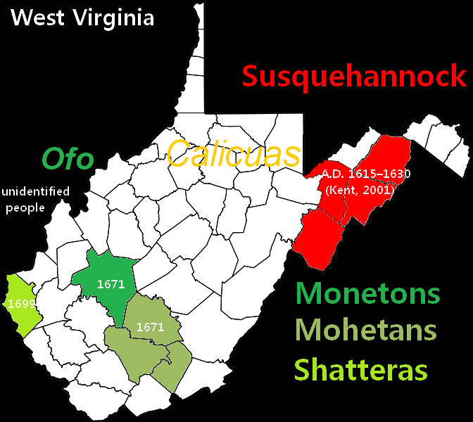
  • The map displays Native American locations in West Virginia during the latter half of the 17th century.
  • It provides insights into the historical presence and distribution of Native American tribes in the region.
  • Understanding this map helps to appreciate the rich cultural heritage of West Virginia’s indigenous peoples.
  • The map serves as a valuable resource for researchers, historians, and anyone interested in Native American history.

History

West Virginia, during the latter half of the 17th century, was inhabited by various Native American tribes. The map of Native American locations in West Virginia sheds light on their presence and distribution across the region.

The 17th century was a time of significant change in the West Virginia area. European explorers and settlers were increasingly encroaching upon Native American territories, leading to clashes and migrations. This map captures the landscape before these dramatic encounters altered the course of history.

Unique Insights

The map offers unique insights into the rich cultural tapestry woven by the Native American tribes in West Virginia. It depicts the various tribal territories, including the Cherokee, Delaware, Shawnee, and Iroquois nations, among others. The map showcases their settlements, trading routes, and other important locations.

Relevant Facts about Native American Locations in WV (Late 17th Century)

Tribes Main Locations Significance
Cherokee Eastern and southeastern areas of West Virginia Strongly influenced trade and diplomacy
Delaware Northern portions of West Virginia Active participants in fur trade networks
Shawnee Southwestern regions of West Virginia Skilled hunters and traders
Iroquois Confederacy North-central parts of West Virginia Significant political and military influence

FAQ

1. Which Native American tribes lived in West Virginia during the latter half of the 17th century?

The major tribes present in West Virginia during this time were the Cherokee, Delaware, Shawnee, and Iroquois Confederacy.

2. What were the main locations of these tribes in West Virginia?

The Cherokee inhabited the eastern and southeastern areas, while the Delaware occupied northern portions. The Shawnee were present in southwestern regions, and the Iroquois Confederacy had a stronghold in the north-central parts of West Virginia.

3. What was the significance of these Native American locations in West Virginia?

The Cherokee exerted strong influence over trade and diplomacy, the Delaware actively participated in fur trade networks, the Shawnee were skilled hunters and traders, and the Iroquois Confederacy held significant political and military influence.

4. Did these tribes interact with each other?

Yes, these tribes interacted with each other through trading, shared hunting grounds, and diplomatic relations.

5. How did European colonization affect Native American territories in West Virginia?

European colonization led to increasing encroachment on Native American territories, which eventually resulted in conflicts, treaties, and forced relocations.

6. Are there any remnants of Native American culture in present-day West Virginia?

Yes, there are remnants of Native American culture in West Virginia today. Artifacts, archaeological sites, and the state’s commitment to preserving indigenous heritage provide glimpses into their rich history.

7. Where can I find more information about Native American history in West Virginia?

For more information about Native American history in West Virginia, you can visit the West Virginia State Archives, local historical societies, and online resources such as the West Virginia Division of Culture and History website.

External Links

LSI Keywords

  • Native American locations in WV
  • 17th century Native American tribes in West Virginia
  • Cherokee tribe in WV
  • Delaware tribe in West Virginia
  • Shawnee tribe in WV
  • Iroquois Confederacy in West Virginia
  • Native American interactions in West Virginia
  • European colonization in West Virginia
  • Preservation of Native American heritage in WV
]]>
“Plan of Plymouth Harbour” from the late 17th Century. From the King George III Topographical Collection. – Land of Maps /plan-of-plymouth-harbour-from-the-late-17th-century-from-the-king-george-iii-topographical-collection/ /plan-of-plymouth-harbour-from-the-late-17th-century-from-the-king-george-iii-topographical-collection/#respond Sat, 29 Apr 2023 10:30:38 +0000 http://localhost/landofmaps/2023/04/29/plan-of-plymouth-harbour-from-the-late-17th-century-from-the-king-george-iii-topographical-collection-land-of-maps/ “Plan of Plymouth Harbour” from the late 17th Century. From the King George III Topographical Collection. – Land of Maps

Introduction: Exploring the “Plan of Plymouth Harbour” from the late 17th Century

The “Plan of Plymouth Harbour” from the late 17th Century is an invaluable historical document that provides a detailed glimpse into the maritime landscape of Plymouth during that time. This plan is part of the esteemed King George III Topographical Collection, which contains a vast array of maps, charts, and views from all over the world.

By analyzing this plan, we can gain insight into the historical significance of Plymouth Harbour and understand its important role in maritime trade and navigation. The plan not only showcases the layout of the harbor but also features key landmarks and navigational markers that were crucial for sailors.

In this article, we will delve into the intricacies of the “Plan of Plymouth Harbour”, decoding its details and tracing its legacy. We will also explore the artistic and cartographic merits of the plan, highlighting its importance as both a historical artifact and a work of art.

Unveiling the King George III Topographical Collection

The King George III Topographical Collection is a treasure trove of maps and charts that were acquired by King George III himself. The collection spans several centuries, providing a comprehensive panorama of the world during that time. The “Plan of Plymouth Harbour” is one of the many exceptional pieces in this collection.

By preserving these maps and making them accessible to the public, the collection allows us to study and appreciate the rich history and geography of different regions. It offers a unique opportunity to examine the development of cartography and the advancements made in maritime navigation throughout history.

The Plan of Plymouth Harbour offers a window into the past, enabling us to understand the layout and structure of one of England’s most significant harbors. It also sheds light on the strategic importance of Plymouth during the late 17th Century.

Understanding the Historical Significance of the Plan

The “Plan of Plymouth Harbour” holds immense historical significance as it reveals the diverse activities that took place within the harbor, such as trade, fishing, and naval operations. Plymouth, being a major port during the 17th Century, played a crucial role in supporting England’s maritime endeavors.

The plan also highlights the fortifications that were built to protect the harbor, including the famous Plymouth Citadel. These fortifications were essential in maintaining the security and defense of the area.

Additionally, the Plan of Plymouth Harbour provides valuable information about the transformation of the harbor over time. By comparing it to present-day maps, historians can understand the changes that have occurred in terms of land reclamation, port expansions, and urban development in Plymouth.

Decoding the Details: Key Features of Plymouth Harbour

The “Plan of Plymouth Harbour” meticulously depicts the layout of the harbor, showcasing important features and landmarks. Key elements of the plan include:

  • An accurate representation of the various docks and anchorages within the harbor.
  • Specific navigational markers, such as lighthouses and buoys, that guided ships entering and exiting the harbor.
  • Markers for navigable channels and restricted areas, ensuring safe passage for vessels.
  • Icons and symbols representing specific hazards, such as rocks or sandbanks, to caution sailors.
  • Labels identifying key buildings, quays, and other structures along the harbor waterfront.

All these elements combine to create a comprehensive overview of the harbor, allowing sailors and navigators to easily understand and navigate the waters of Plymouth.

Tracing the Legacy: Influence of the Plan on Marine Navigation

The “Plan of Plymouth Harbour” served as a vital tool for mariners navigating the waters of Plymouth during the late 17th Century. Its accuracy and detail provided essential assistance in safe port entry and navigation through the harbor.

Many of the navigational markers and landmarks depicted in the plan still exist today, reflecting the enduring legacy of the original chart. The plan served as a foundation for subsequent maps and charts of Plymouth Harbour, influencing the cartography of the region for years to come.

Frequently Asked Questions about the “Plan of Plymouth Harbour”

1. Who created the “Plan of Plymouth Harbour”?

The plan was created by John Seller, a renowned English cartographer, and publisher during the late 17th Century. Seller was known for his accurate and detailed maps of British coastal areas.

2. How was the “Plan of Plymouth Harbour” used by sailors?

The plan served as a navigational aid for sailors entering or departing Plymouth Harbour. It provided crucial information about potential hazards, navigable channels, and landmarks, ensuring safe and efficient navigation.

3. Is the “Plan of Plymouth Harbour” still relevant today?

Although the plan is from the late 17th Century, it still holds historical value and offers insights into the development of Plymouth Harbour. While navigational technology has significantly advanced, the plan serves as a reference point to trace the changes and heritage of the harbor.

4. How does the plan compare to modern-day maps?

While some features of the harbor may have changed over time due to urban development and land reclamation, the overall topography and key landmarks depicted in the plan are still recognizable on modern maps of Plymouth Harbour.

5. Can I view the “Plan of Plymouth Harbour” in person?

Yes, the original “Plan of Plymouth Harbour” is housed in the King George III Topographical Collection, which is part of the British Library in London. It may be possible to view the plan by making an appointment with the library.

Examining the Artistic and Cartographic Merits of the Plan

In addition to its historical and navigational significance, the “Plan of Plymouth Harbour” also possesses artistic and cartographic merits. The attention to detail and skillful execution of the plan make it a work of both historical and aesthetic value.

The beauty of the plan lies in its harmonious blend of accuracy and artistry. The watercoloring techniques used to add depth and texture to the map, combined with the precise representation of geographic features, create a visually appealing composition.

Moreover, the intricate illustrations of ships, fortifications, and other structures along the harbor reflect the artistic expertise of the cartographer. These embellishments elevate the plan from a mere technical chart to a captivating work of art.

Conclusion: Preserving the Rich Heritage of Plymouth Harbour

The “Plan of Plymouth Harbour” from the late 17th Century serves as a gateway to the past, unlocking the secrets and heritage of Plymouth’s maritime history. Through its depiction of the harbor’s layout, navigational aids, and landmarks, it offers a fascinating insight into the maritime world of the time.

By preserving and studying this exceptional document, we can ensure that the rich heritage of Plymouth Harbour continues to be appreciated and understood by future generations. The plan serves as a reminder of the historical significance of Plymouth and highlights its ongoing importance as a maritime hub.

As we explore the legacy of the “Plan of Plymouth Harbour,” we recognize its artistic and cartographic merits. The plan showcases the skills of John Seller, providing us with a unique and beautiful representation of the maritime landscape of Plymouth.

Let us cherish and protect these invaluable historical artifacts, ensuring that the heritage of Plymouth Harbour and its significance in naval history remain forever engraved in our collective memory.

]]>
/plan-of-plymouth-harbour-from-the-late-17th-century-from-the-king-george-iii-topographical-collection/feed/ 0