Static v2 STAGING — not production. Live site
Land of MapsAtlas edition
Maps & cartography
Land of Maps
events – LandofMaps.com https://landofmaps.com Maps, Charts, Reports, Infographics, Vectors, Art. Discover interesting things about the world! Fri, 22 Sep 2023 17:59:39 +0000 en-US hourly 1 /wp-content/uploads/2023/09/landofmaps_logo.png events – LandofMaps.com https://landofmaps.com 32 32 Wembley Stadium Map /wembley-stadium-map/ Fri, 22 Sep 2023 17:59:39 +0000 /?p=17244

Wembley Stadium Map

Wembley Stadium Map – All You Need to Know

Key Takeaways

  • Wembley Stadium is located in London, England and is known as the home of English football.
  • The stadium has a seating capacity of 90,000 and hosts various sporting events, concerts, and other live performances.
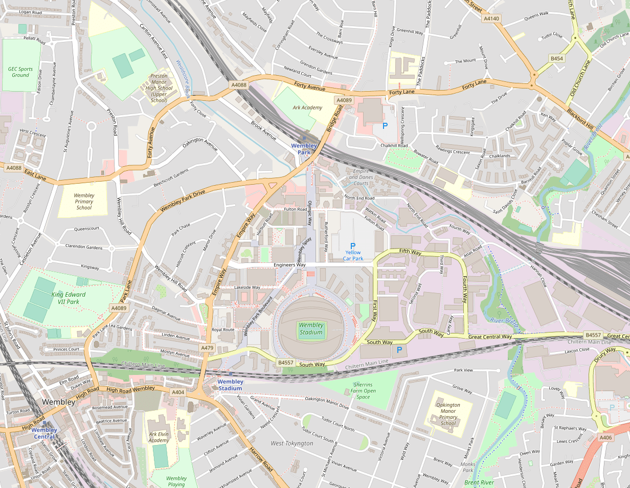
  • Exploring the Wembley Stadium map allows visitors to navigate the stadium’s facilities, seating areas, entrances, and important landmarks.
  • The map provides a comprehensive guide for visitors to enhance their experience and discover everything Wembley Stadium has to offer.
  • Wembley Stadium offers state-of-the-art facilities, including restaurants, bars, and merchandise stores.

History

Wembley Stadium, originally known as the Empire Stadium, was built in 1923 in Wembley Park, London. It was constructed for the British Empire Exhibition and served as the centerpiece for the event. The stadium’s iconic twin towers became a symbol of British sporting excellence.

The first event held at Wembley Stadium was the FA Cup Final in 1923. Since then, the stadium has been a significant venue for football matches, major sporting events, and memorable concerts. It hosted the 1948 Olympic Games and the 1966 FIFA World Cup final, where England claimed their first and only World Cup victory.

The original Wembley Stadium underwent renovations during the early 2000s and was officially reopened in 2007. The design of the new stadium incorporated modern features while preserving the historical elements of the old stadium, such as the twin towers.

Unique Insights

  • One of the most remarkable features of Wembley Stadium is its iconic arch, which stands 133 meters tall. It provides support to the roof and adds to the grandeur of the stadium.
  • The arch also lights up at night with vibrant colors, creating a visually stunning display.
  • Wembley Stadium has hosted some of the most epic music concerts, including performances by legendary artists like Queen, Adele, and Ed Sheeran.
  • The stadium’s excellent transport links make it easily accessible from various parts of London, with multiple train and bus routes.
  • The Wembley Stadium map showcases various amenities, including food and beverage options, restrooms, and first aid stations, ensuring visitors have a comfortable experience.
  • Wembley Stadium embraces sustainability and has implemented several eco-friendly initiatives, including solar panels and rainwater harvesting.

Table of Relevant Facts

Year Event
1923 First FA Cup Final held at Wembley Stadium
1948 Wembley Stadium hosts the Olympic Games
1966 Wembley Stadium hosts the FIFA World Cup final
2007 Wembley Stadium reopened after renovations

Frequently Asked Questions

  1. How many seats are there in Wembley Stadium?

    Wembley Stadium has a seating capacity of 90,000, making it one of the largest stadiums in the United Kingdom.

  2. What is the best way to reach Wembley Stadium?

    The stadium is well connected by public transportation, including trains, buses, and the underground. Visitors can easily reach the stadium from various parts of London.

  3. Can I take a guided tour of Wembley Stadium?

    Yes, guided tours of Wembley Stadium are available, providing visitors with the opportunity to explore the stadium, learn about its history, and access areas that are usually restricted during events.

  4. Are there parking facilities at Wembley Stadium?

    Yes, there are several parking options available near the stadium. However, it is advisable to check for parking arrangements in advance, as availability may vary depending on the event.

  5. What amenities are available at Wembley Stadium?

    Wembley Stadium offers a range of amenities, including food and beverage outlets, merchandise stores, restrooms, and first aid facilities. There are also accessible facilities for disabled visitors.

  6. Can I bring my own food and drinks to Wembley Stadium?

    No, outside food and drinks are not permitted inside the stadium. However, there are ample food and beverage options available within the premises.

  7. What are some upcoming events at Wembley Stadium?

    Upcoming events at Wembley Stadium include football matches, music concerts, and other live performances. It is recommended to check the official Wembley Stadium website for the latest event schedule.

Additional Resources

LSI Keywords

  • Wembley Stadium map
  • London football stadium
  • English football
  • Wembley Stadium arch
  • Transportation to Wembley Stadium
  • Wembley Stadium amenities
  • Wembley Stadium history
  • Guided tour of Wembley Stadium
  • Wembley Stadium parking
  • Upcoming events at Wembley Stadium
]]>
1944 Map Of The World Showing Events Of World War Ii /1944-map-of-the-world-showing-events-of-world-war-ii/ Fri, 22 Sep 2023 00:27:38 +0000 /?p=17414

1944 Map Of The World Showing Events Of World War Ii

1944 Map Of The World Showing Events Of World War II

Key Takeaways

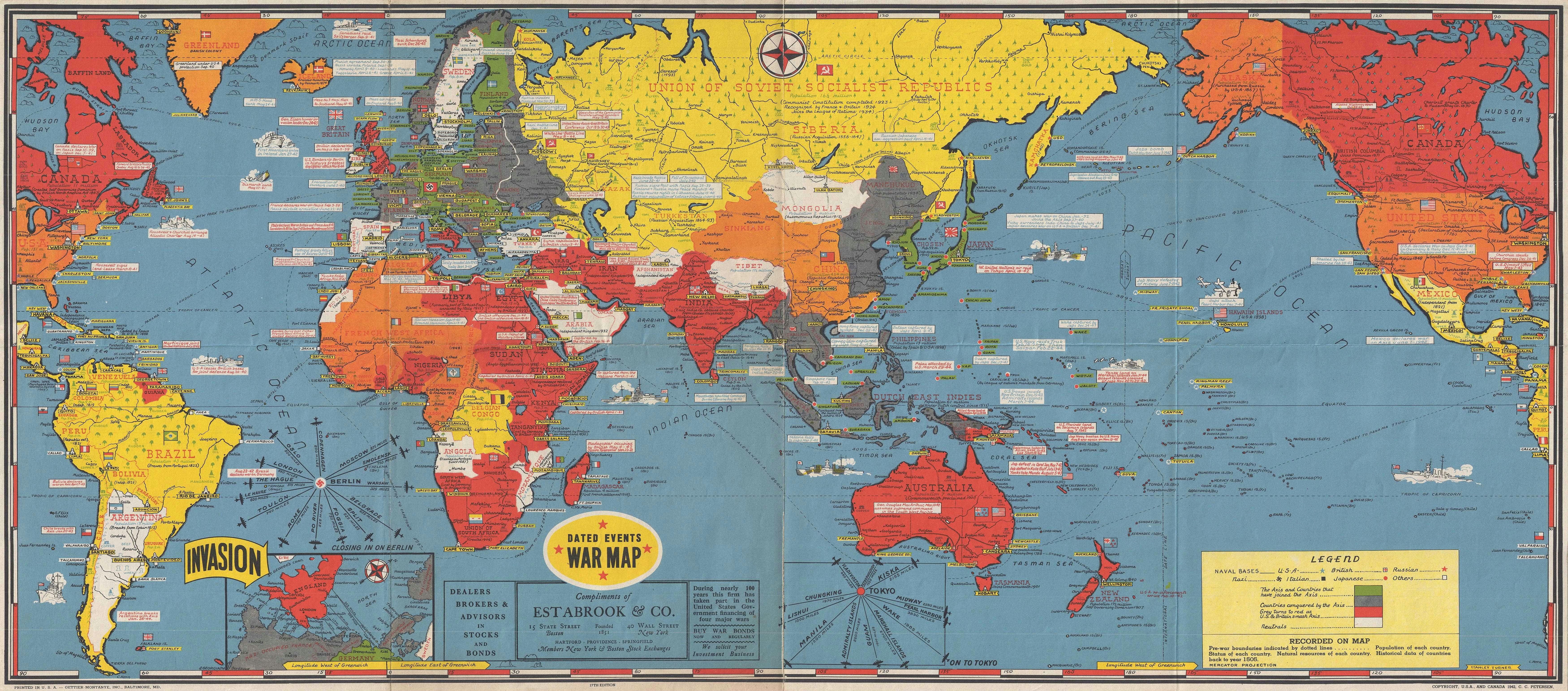
  • The 1944 map of the world provides a comprehensive overview of the events that occurred during World War II.
  • By studying this map, one can gain insights into the strategies, alliances, and battles that shaped the global conflict.
  • It showcases the major countries and theaters of war involved, offering a valuable resource for historians, educators, and enthusiasts.
  • This article explores the historical significance of the map, providing unique insights into the global conflict during 1944.

History

The 1944 map of the world depicting the events of World War II serves as a remarkable source of historical information. Produced during a critical period of the war, it captures the geopolitical landscape and military strategies in play during this time.

World War II was a global conflict that occurred from 1939 to 1945, involving many nations. By 1944, the war had reached a crucial stage, with numerous significant events shaping the outcome.

The map provides a visual representation of the different theaters of war, highlighting the major battles, alliances, and occupations of many countries. It was designed to aid in understanding the war’s progress, both for military and civilian purposes.

Unique Insights

  • The map showcases the key events of World War II in 1944, including the D-Day invasion, the Battle of Stalingrad, and the Allied advances in the Pacific.
  • It demonstrates the shifting alliances and territorial changes that occurred during this period, with the Allied Powers making significant advancements against Axis forces.
  • This map highlights the immense scale of World War II, with battles taking place across Europe, Asia, and the Pacific.
  • It provides a clear visualization of the resources and infrastructure that different countries possessed at the time, such as naval bases, airfields, and major cities.

Table of Relevant Facts during 1944

Event Date Significance
D-Day Invasion of Normandy June 6, 1944 A major turning point in the war, marking the beginning of the liberation of Western Europe from Nazi Germany.
Battle of Stalingrad August 23, 1942 – February 2, 1943 A decisive Soviet victory, halting the German advance into the Soviet Union and turning the tide of the war in favor of the Allies.
Allied Advances in the Pacific 1944 The Allies made significant strides in the Pacific theater, retaking various islands from the Japanese forces.
Battle of the Bulge December 16, 1944 – January 25, 1945 The last major German offensive campaign on the Western Front during World War II, resulting in heavy casualties.

FAQ

1. What does the map depict?

The map depicts the events of World War II in the year 1944, showcasing the major countries involved, battles, and key theaters of war.

2. How can this map be useful for historians?

This map provides historians with a valuable visual aid to better understand the geopolitical and strategic complexities of World War II during 1944.

3. Are there any specific areas highlighted on the map?

Yes, the map highlights the European theater, the Pacific region, and notable battles such as the D-Day invasion and the Battle of Stalingrad.

4. Is this map considered historically accurate?

While the map provides a general representation of the events during 1944, it is important to acknowledge that due to the limits of cartographic technology at the time, certain inaccuracies may be present.

5. Can I find information about individual battles on this map?

Yes, the map includes major battles and their locations, allowing users to discern the significant engagements that took place during the stated timeframe.

6. Where can I find this map?

The map can be found in various historical archives, museums, or through online resources that specialize in collectible maps and historical artifacts.

7. How can I use this map for educational purposes?

The map serves as an excellent educational tool by illustrating the global scale of World War II and helping students visualize the progress of the war during a critical year.

External Links

LSI Keywords

  • World War II in 1944
  • Major events of 1944
  • D-Day invasion
  • Battle of Stalingrad
  • Allied advances in the Pacific
  • Geopolitical landscape of World War II
  • Map of World War II
  • World War II educational resource
]]>