12 Tribes of Israel
Click or tap the map to enlarge it.
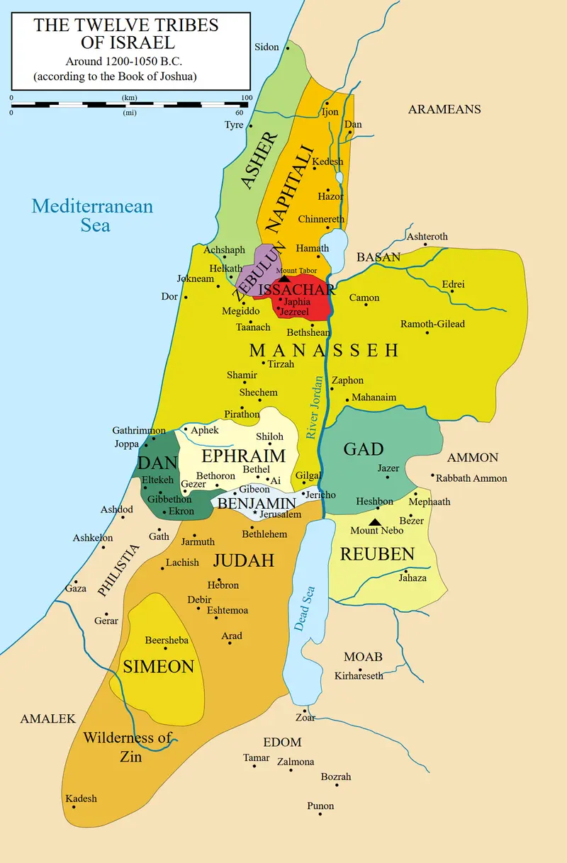
Map of the 12 Tribes of Israel
Facts Table
| Tribe | Biblical Founder | Symbol | Territory |
|---|---|---|---|
| Reuben | Reuben | Water | Transjordan region |
| Simeon | Simeon | City | Part of Judah’s territory |
| Levi | Levi | Priestly Utensils | No distinct territory; scattered cities and priestly role |
| Judah | Judah | Lion | Southern region with Jerusalem as its center |
| Dan | Dan | Scales | Northernmost region near the coast |
| Naphtali | Naphtali | Deer | Upper Galilee region in the north |
| Gad | Gad | Tent | Transjordan region |
| Asher | Asher | Olive Tree | Northwestern region near the coast |
| Issachar | Issachar | Donkey | Lower Galilee region in the north |
| Zebulun | Zebulun | Ship | Coastal region between Naphtali and Issachar |
| Joseph | Joseph | Bull | Ephraim in the west and Manasseh in the east |
| Benjamin | Benjamin | Wolf | Central region, just north of Judah |
Frequently Asked Questions
1. Why were the territories of the 12 Tribes divided?
The territories were divided among the 12 Tribes to fulfill the promises and blessings given by Jacob and Moses, and to establish each tribe’s ancestral inheritance.
2. How were the territories allocated?
The allocation was determined based on various factors, including population size, historical significance, and the blessings bestowed upon each tribe.
3. What is the significance of the map of the 12 Tribes of Israel?
The map provides a visual representation of the division of land among the tribes and helps us understand the historical and geographic context of ancient Israel.
4. Can the boundaries of the tribes be accurately determined?
The boundaries of the tribes are subject to interpretation and may have changed over time due to various factors such as warfare, migration, and political shifts.
Related Maps: One of Winston Churchill’s maps in the Cabinet War Rooms, where the British Prime Minister and his team used to track the progress of the war – Land of Maps5. How does the map relate to the history of Israel?
The map is a key resource for studying the distribution of power, influence, and the historical events that took place in different regions of ancient Israel.
6. Are there any modern-day implications of the 12 Tribes map?
While the divisions of the tribes hold historical and cultural significance, they do not have direct implications in modern times as the original tribal structure has not been completely maintained.
7. Where can I find more information about the 12 Tribes of Israel and their territories?
You can explore further details and references in historical texts, biblical studies, and archaeology publications. Some helpful external links are:
- Bible Study: Israel’s Tribal Land Map
- Joshua 13-21 – The Division of the Land
- Jewish History: The Twelve Tribes of Israel
List of LSI Keywords
- 12 Tribes of Israel
- Tribal territories
- Ancient Israel
- Promised Land
- Israelite tribes
- Divisions of the tribes
- Historical context of Israel
- Biblical significance
- Geographical allocation
- Moses and Jacob’s blessings
- Land inheritance
- Tribe territories and symbols
- Power distribution among tribes
- 12 Tribes map analysis