1866 Johnson Map of Kentucky and Tennessee
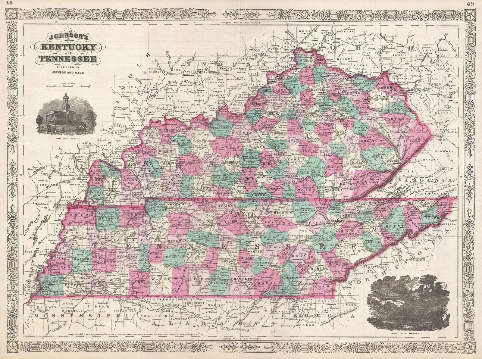
Click or tap the map to enlarge it.
Key Takeaways
- The 1866 Johnson Map of Kentucky and Tennessee provides a detailed representation of the two states during that era.
- This historic map offers insights into the geography, topography, cities, and transportation networks of Kentucky and Tennessee.
- The map serves as a valuable resource for historical research, educational purposes, and an appreciation for cartography.
History
The 1866 Johnson Map of Kentucky and Tennessee, known as “Geographicus Kentuckytennesseejohnson1866,” was published by A.J. Johnson. This map was part of a series of maps produced by the Johnson family, who were prominent cartographers in the 19th century. Their maps were renowned for their accuracy, attention to detail, and artistic elements.
This particular map showcases the states of Kentucky and Tennessee, which were important regions during the mid-1800s. It was created during a period of significant changes and developments in both states, both socially and economically.
Unique Insights
By examining the 1866 Johnson Map of Kentucky and Tennessee, several unique insights can be gained:
- The map provides a detailed depiction of the topography and geography of both states, including rivers, lakes, mountains, and valleys, giving viewers a sense of the natural landscape during that time.
- City names, along with their respective sizes, are clearly labeled on the map, allowing researchers to understand the urbanization and settlement patterns of the era.
- The transportation networks, including major roads, railroads, and canals, indicate the crucial transportation routes connecting various cities and regions within Kentucky and Tennessee.
- Additionally, the map showcases county boundaries and names, aiding in the understanding of the administrative divisions of the two states during the 19th century.
Table of Relevant Facts
| Year | Event |
|---|---|
| 1866 | Publication of the Johnson Map of Kentucky and Tennessee |
| Mid-19th century | Rapid urbanization and economic growth in Kentucky and Tennessee |
| 19th century | Expansion of transportation networks in the two states |
FAQ
-
Can I still find physical copies of this map?
Physical copies of the Johnson Map of Kentucky and Tennessee might be available in antique stores, specialized map collections, or through online auctions. However, their availability may be limited, and acquiring an original copy can be quite expensive.
-
How accurate is this map compared to modern maps?
While this map was highly accurate for its time, it is important to note that cartographic techniques and geographical knowledge have advanced significantly since 1866. Therefore, for precise modern geographical information, it is best to rely on up-to-date maps.
-
What can I learn about the cities from this map?
The Johnson Map of Kentucky and Tennessee provides information about the size and location of cities during the mid-19th century. This can offer insights into the population distribution, economic significance, and the development of urban centers in the region.
-
Were there any famous landmarks included on this map?
While the map primarily focuses on the geographic and administrative aspects of Kentucky and Tennessee, it may include prominent landmarks such as notable buildings, churches, or historical places that were significant during that time.
-
What can I learn about the transportation systems?
The Johnson Map of Kentucky and Tennessee showcases the major roads, railroads, and canals of the two states. By analyzing the transportation networks depicted on the map, one can gain insights into the connectivity of cities and the transportation infrastructure of that era.
-
Can this map be used for educational purposes?
Absolutely! The 1866 Johnson Map of Kentucky and Tennessee is a valuable resource for educational purposes. It can help students understand the historical geography and development of both states, as well as the cartographic techniques employed during the 19th century.
-
Are there other maps created by the Johnson family?
Yes, the Johnson family was known for producing a series of maps covering various regions of the United States. Some of their other maps include those of neighboring states, national maps, and even world maps.