1870 Vaux and Olmstead Map of Prospect Park Brooklyn New York
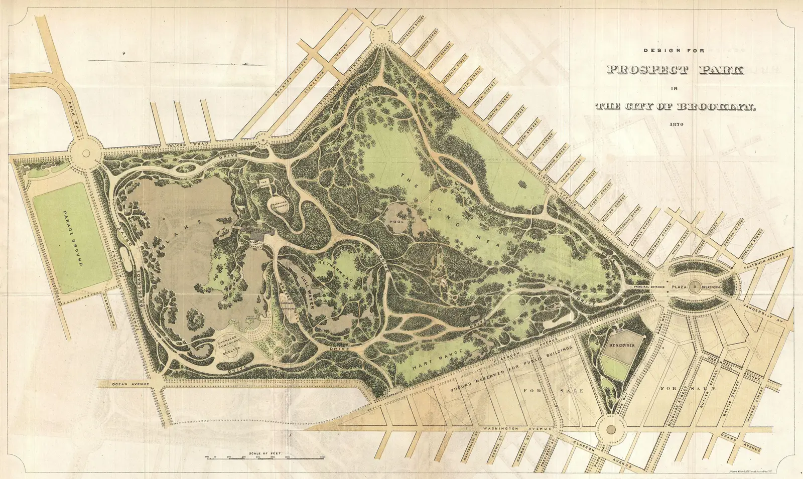
Click or tap the map to enlarge it.
1870 Vaux And Olmstead Map Of Prospect Park Brooklyn New York
Key Takeaways
- The 1870 Vaux and Olmstead Map of Prospect Park, Brooklyn, New York is a historic cartographic representation of this iconic location.
- The map provides valuable insights into the park’s design, landmarks, and geographical features during that time period.
- It served as a blueprint for the creation of one of Brooklyn’s most beloved public parks.
History
The 1870 Vaux and Olmstead Map of Prospect Park, Brooklyn, New York is a significant historical document that showcases the early stages of this iconic urban park’s development. Frederick Law Olmsted and Calvert Vaux, renowned landscape architects, were commissioned in 1865 to design the park.
The map itself was created in 1870 and served as a crucial tool for the realization of their ambitious plans. It illustrates the intricate details of the park’s design, including its topography, roadways, water bodies, and green spaces. This map beautifully captures their vision and demonstrates the meticulous planning that went into creating Prospect Park.
Unique Insights
The 1870 Vaux and Olmstead Map provides unique insights into the park’s layout and features during that specific time period. Some notable details include:
- The presence of the Long Meadow, a vast open space that stretches across the park and serves as a gathering place for recreational activities.
- The intricate network of pathways and trails that wind through the park, allowing visitors to explore its various areas.
- The inclusion of the Lake, a prominent water body that adds to the park’s natural beauty.
- The marked locations of major landmarks, such as the Boathouse, Concert Grove, and Litchfield Villa.
Table of Relevant Facts
| Date | Event |
|---|---|
| 1865 | Frederick Law Olmsted and Calvert Vaux are commissioned to design Prospect Park. |
| 1870 | The Vaux and Olmstead Map of Prospect Park is created. |
Frequently Asked Questions (FAQ)
-
Who were Frederick Law Olmsted and Calvert Vaux?
Frederick Law Olmsted and Calvert Vaux were renowned landscape architects responsible for designing many influential parks and landscapes, including Central Park in New York City.
-
What is the significance of the 1870 Vaux and Olmstead Map?
The 1870 Vaux and Olmstead Map provides valuable insights into the early development and design of Prospect Park, Brooklyn, capturing its layout and features during that specific time period.
-
Why is Prospect Park important?
Prospect Park is an important urban park in Brooklyn, New York, known for its beautiful landscapes, recreational amenities, and cultural landmarks. It plays a crucial role in the community as a place for relaxation and outdoor activities.
-
What are some notable features of Prospect Park in the 1870 Vaux and Olmstead Map?
The map showcases the Long Meadow, a large open area, the Lake, various pathways and trails, and important landmarks such as the Boathouse, Concert Grove, and Litchfield Villa.
-
How did the 1870 Vaux and Olmstead Map influence Prospect Park’s creation?
The map served as a blueprint for the park’s development and allowed the designers to visualize and implement their plans effectively. It ensured a cohesive and well-designed park layout.
-
Where can I find the original 1870 Vaux and Olmstead Map?
The original 1870 Vaux and Olmstead Map is held in the archives of Prospect Park Alliance, the organization responsible for the park’s maintenance and preservation.
-
What is the current state of Prospect Park?
Prospect Park continues to be a vibrant and beloved public park, attracting visitors from near and far. It has undergone various restorations and improvements over the years while maintaining its original charm.
External Links
LSI Keywords
- Prospect Park Brooklyn
- Frederick Law Olmsted
- Calvert Vaux
- Park design
- Historic maps
- Landscape architecture
- Urban parks
- Brooklyn landmarks
- Green spaces
- Recreational activities