1883 Us Coast Survey Map of West Point Military Academy New York
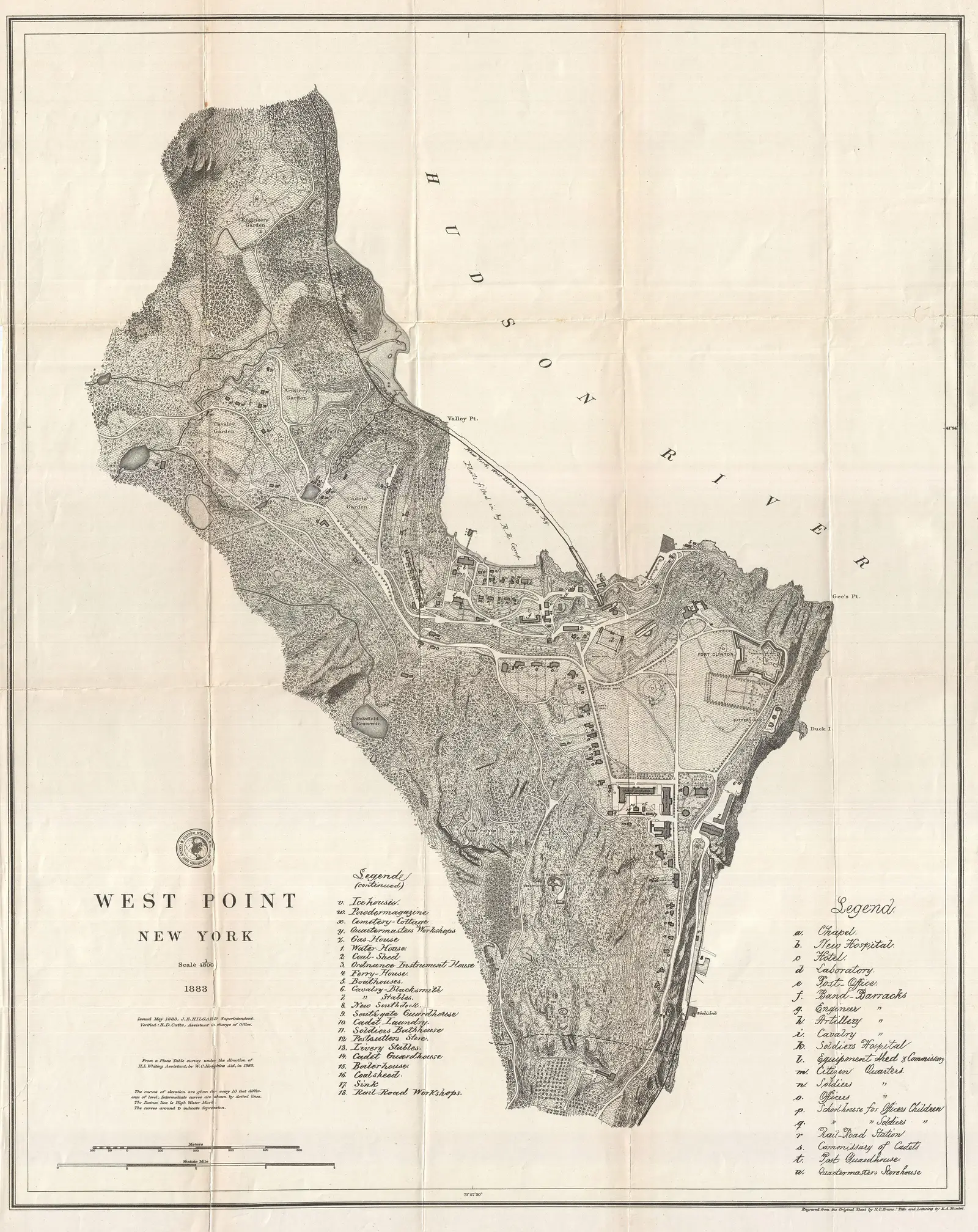
Click or tap the map to enlarge it.
Key Takeaways
- The 1883 US Coast Survey Map of West Point Military Academy, New York offers a detailed representation of the academy and its surrounding areas during that time.
- This historic map provides valuable insights into the geographic layout of the West Point Military Academy and its position within the Hudson River Valley.
- Cartographers from the US Coast Survey meticulously recorded topographical features and landmarks, making this map an essential resource for historians, geographers, and map enthusiasts.
History
The 1883 US Coast Survey Map of West Point Military Academy, also known as “Geographicus Westpointuscs1883,” was created by the US Coast Survey under the direction of the United States Department of Commerce and Labor. The US Coast Survey, established in 1807, played a crucial role in documenting the nation’s coastlines, conducting surveys, and creating charts and maps.
This particular map provides a snapshot of West Point Military Academy, situated on the west bank of the Hudson River, approximately 50 miles north of New York City. The academy, founded in 1802, is one of the oldest military academies in the United States and has a rich history in training military officers.
Unique Insights
The 1883 US Coast Survey Map of West Point Military Academy offers several unique insights into the area during that time:
- The map highlights the various buildings within the academy, including barracks, classrooms, and administrative offices. This provides a comprehensive understanding of the academy’s infrastructure.
- Topographical features such as hills, valleys, and the Hudson River are accurately depicted, allowing viewers to appreciate the natural landscape surrounding the academy.
- The location of Fort Clinton, situated adjacent to West Point Military Academy, is clearly marked on the map. This demonstrates the historical significance of the area for military defense purposes.
- The depiction of roadways and transportation routes provides insight into how people traveled to and from the academy, showcasing the connectivity of the region.
Table: Relevant Facts
| Year | Significant Event |
|---|---|
| 1802 | West Point Military Academy is founded. |
| 1883 | Creation of the 1883 US Coast Survey Map of West Point Military Academy, New York. |
Frequently Asked Questions (FAQ)
-
What is the purpose of the US Coast Survey?
The US Coast Survey was established to document the nation’s coastlines, conduct surveys, and create charts and maps to aid in navigation and defense.
-
How old is West Point Military Academy?
West Point Military Academy was founded in 1802, making it one of the oldest military academies in the United States.
-
Why is West Point Military Academy significant?
West Point Military Academy is significant due to its long history in training military officers and its strategic location on the Hudson River.
-
What landmarks are depicted on the map?
The map depicts various buildings within the West Point Military Academy, Fort Clinton, hills, valleys, and the Hudson River.
-
Who created the 1883 US Coast Survey Map of West Point Military Academy?
The map was created by the US Coast Survey under the direction of the United States Department of Commerce and Labor.
-
What information does the map offer?
The map offers valuable information about the topographical features, roadways, and infrastructure of West Point Military Academy and its surroundings.
-
Why is the 1883 US Coast Survey Map significant?
The map is significant as it provides a detailed representation of West Point Military Academy, offering insights into its historical context and geographic layout.