1895 Map of Taunton Massachusetts East Part
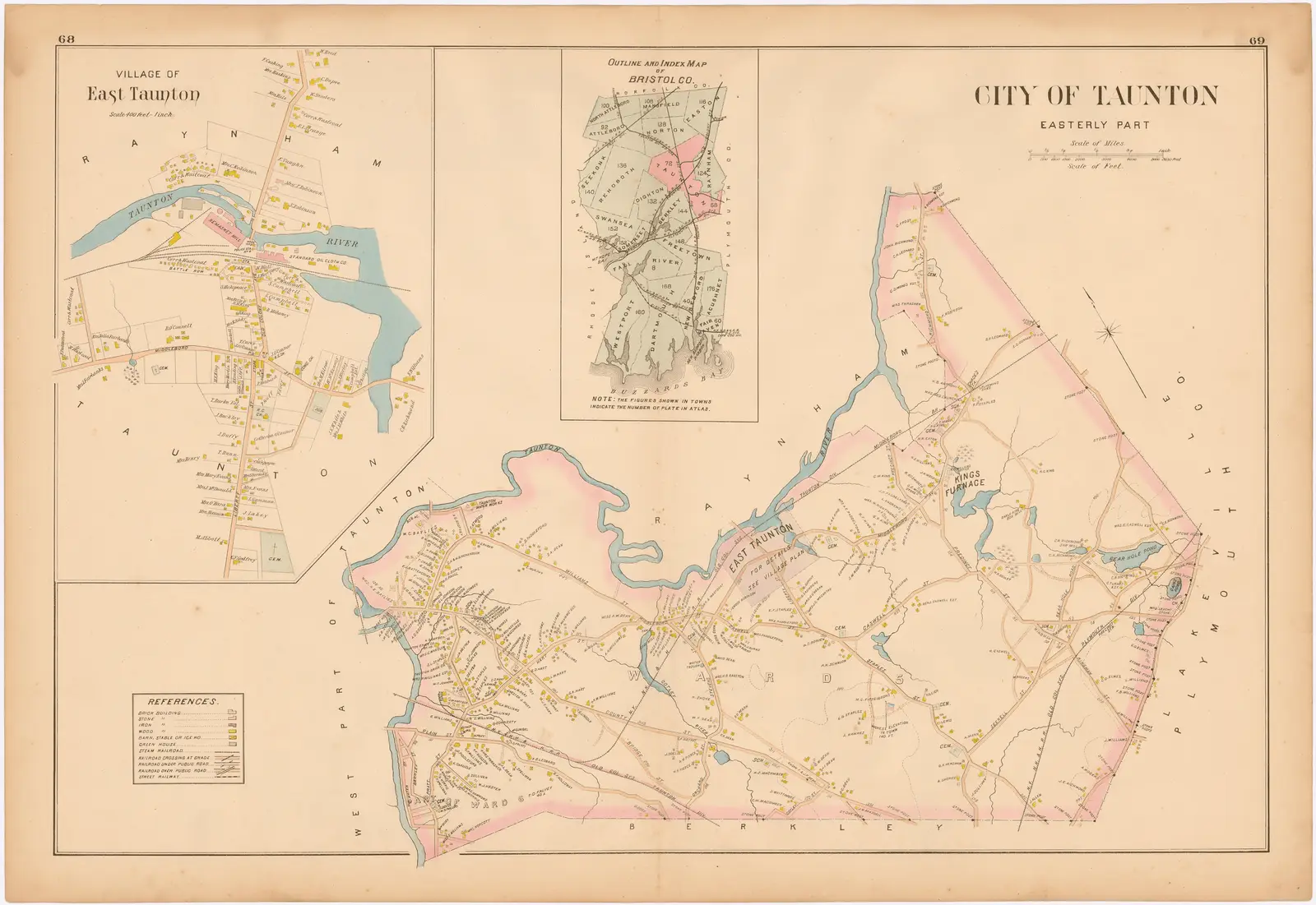
Click or tap the map to enlarge it.
Key Takeaways
- The 1895 Map of Taunton Massachusetts East Part provides a fascinating glimpse into the geography and topography of the region during that time.
- This map showcases the development and layout of Taunton’s eastern part, highlighting important landmarks and infrastructure.
- Studying historical maps like this provides valuable insights into the changes that have taken place over the years.
History
The 1895 Map of Taunton Massachusetts East Part was created during a time when cartography was rapidly advancing. The map was produced using traditional techniques, such as surveying and hand-drawn illustrations, before the era of digital mapping and satellite imagery.
This particular map was commissioned to document the eastern part of Taunton, Massachusetts. It provides a visual representation of the streets, buildings, waterways, and natural features present in the area during the late 19th century.
Maps like these were not only used for navigational purposes but also served as valuable tools for urban planning, land assessment, and historical documentation.
Unique Insights
Examining the 1895 Map of Taunton Massachusetts East Part reveals several unique insights about the region. Some notable observations include:
- The clear division between commercial and residential areas, with an emphasis on the central business district.
- The presence of significant industrial establishments, indicating the economic importance of manufacturing in that era.
- The abundance of green spaces and parks, highlighting the city’s commitment to recreational areas and community well-being.
- The location of transportation hubs, including railway lines and stations, illustrating the importance of rail travel during that time.
Relevant Facts
| Fact | Date |
|---|---|
| Taunton was incorporated as a city | 1864 |
| The Taunton River passes through the city | Year-round |
| Taunton was a center of the silver industry | 19th century |
| Taunton was known for its high-quality leather production | 19th century |
FAQ
1. What is the significance of the 1895 Map of Taunton Massachusetts East Part?
The map provides a valuable historical record of the eastern part of Taunton, showcasing its development, infrastructure, and natural features during the late 19th century.
2. How accurate are the details on the map?
While the map was diligently created using traditional cartographic techniques, some variations may exist due to limitations in surveying methods available at that time.
3. What landmarks or buildings of historical importance can be found on the map?
The map highlights several significant landmarks, including the City Hall, churches, factories, parks, and railway stations that played crucial roles in the city’s development.
4. Can the modern boundaries of Taunton be compared to those on the map?
Over time, the boundaries of cities and towns often undergo changes due to annexation, redistricting, and urban development. It is recommended to refer to current maps for accurate boundary information.
5. How can this map be used for genealogical research?
The map can be a valuable resource for genealogical research, providing insights into the neighborhoods and streets where ancestors may have lived during the late 19th century in Taunton’s eastern part.
6. Are there any digital versions of the map available?
While the original map may be housed in specialized collections or archives, digital versions or high-resolution reproductions may be accessible through online platforms, historical societies, or libraries.
7. Can this map be used for educational purposes?
Yes, the 1895 Map of Taunton Massachusetts East Part can be an excellent educational tool to explore urban development, historical geography, and changes in a city’s landscape over time.