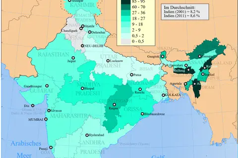
2011 Census Scheduled Tribes Distribution Map India by State and Union Territory
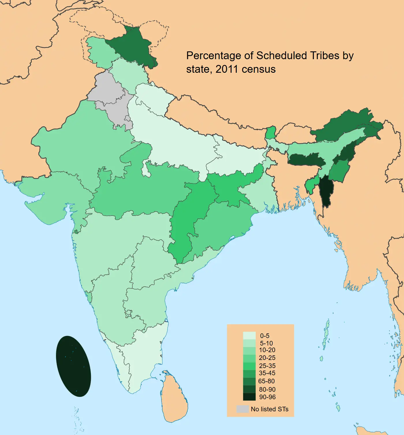
Click or tap the map to enlarge it.
Key Takeaways
- The 2011 Census Scheduled Tribes Distribution Map of India provides an overview of the distribution of scheduled tribes across different states and union territories.
- It offers valuable insights into the demographic landscape of India, highlighting the tribal communities’ presence in various regions.
- The map serves as a valuable resource for researchers, policymakers, and anyone interested in understanding the tribal population distribution in India.
History of the Map
The 2011 Census Scheduled Tribes Distribution Map India By State And Union Territory is a product of the Indian Census, conducted in 2011. The Census is a massive survey carried out every ten years to gather demographic and socio-economic data across the country.
One of the essential aspects of the Census is the identification and categorization of scheduled tribes, who are recognized as historically disadvantaged indigenous communities in India. The tribes have unique cultural traditions and face numerous challenges.
The Significance of the Map
The map highlights the geographical distribution of scheduled tribes within the different states and union territories of India. It provides a visual representation of the tribal population concentration and dispersion across the nation.
By studying the map, researchers can analyze the regional dynamics of tribal communities, their influence on local cultures, and the challenges they face in specific areas.
Unique Insights
By examining the 2011 Census Scheduled Tribes Distribution Map India By State And Union Territory, we gain several unique insights:
- The northeastern states of India, such as Arunachal Pradesh, Nagaland, and Mizoram, have a significant concentration of scheduled tribes. These regions are known for their diverse tribal cultures.
- The central Indian states, like Chhattisgarh, Jharkhand, and Madhya Pradesh, also have a notable presence of scheduled tribes. This indicates the tribes’ affinity towards forested and hilly terrains.
- The southern states of Tamil Nadu and Kerala show a relatively lower concentration of scheduled tribes when compared to other regions of India.
- A noticeable concentration of scheduled tribes can be observed in the Andaman and Nicobar Islands, which are home to several indigenous communities.
Table of Relevant Facts
| State/Union Territory | Scheduled Tribes Population (2011) |
|---|---|
| Arunachal Pradesh | 1,420,275 |
| Mizoram | 832,224 |
| Chhattisgarh | 6,063,063 |
| Jharkhand | 8,615,165 |
| Tamil Nadu | 3,728,683 |
| Andaman and Nicobar Islands | 32,987 |
Frequently Asked Questions (FAQ)
-
What is the purpose of the 2011 Census Scheduled Tribes Distribution Map India By State And Union Territory?
The purpose of the map is to provide an overview of the distribution of scheduled tribes across India’s different states and union territories.
-
Why is it important to study the distribution of scheduled tribes?
Studying the distribution helps understand the demographic landscape, influence on local cultures, and challenges faced by tribal communities in specific regions.
-
Which states have the highest concentration of scheduled tribes?
Arunachal Pradesh, Mizoram, and Chhattisgarh have a significant concentration of scheduled tribes.
-
Are there any regions in India with a relatively lower concentration of scheduled tribes?
The southern states of Tamil Nadu and Kerala show a relatively lower concentration of scheduled tribes.
-
What unique insights can be gained from this map?
The map reveals the concentration of scheduled tribes in northeastern states, central Indian states, and the Andaman and Nicobar Islands.
-
How often is the Indian Census conducted?
The Indian Census is conducted every ten years.
-
What is the significance of scheduled tribes in Indian society?
Scheduled tribes are recognized as historically disadvantaged indigenous communities with unique cultural traditions.