Addis Ababa District Map
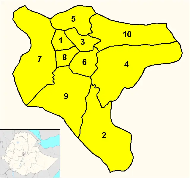
Click or tap the map to enlarge it.
Addis Ababa District Map – A Comprehensive Overview
Key Takeaways
- Addis Ababa, the capital of Ethiopia, consists of ten administrative sub-cities, each with its distinct character and landmarks.
- The Addis Ababa District Map provides a detailed layout of the city’s sub-cities, major roads, landmarks, and points of interest.
- Exploring the map helps visitors and residents navigate the city, discover new areas, and plan their journeys more efficiently.
- Understanding the historical and cultural significance of each district enriches the experience of exploring Addis Ababa.
- From bustling commercial areas to serene residential neighborhoods, Addis Ababa offers a diverse range of experiences for all.
History of Addis Ababa
Addis Ababa, which translates to “New Flower” in Amharic, was founded in 1886 by Emperor Menelik II. The city’s location was strategically chosen to serve as the capital of Ethiopia, replacing the previous capital of Entoto. Over the years, Addis Ababa has expanded and evolved into a vibrant metropolis that blends modernity with its rich cultural heritage.
Unique Insights
The Addis Ababa District Map showcases the city’s growth and development through different historical periods. It highlights the following unique insights:
- The Piazza District: This area was the heart of the city during the Italian occupation of Ethiopia. It still retains its colonial-era charm with its architecture and vibrant atmosphere.
- Bole District: Known for its international airport and numerous hotels, Bole is the commercial and entertainment hub of Addis Ababa. It attracts visitors from around the world.
- Kirkos District: Situated in the city center, Kirkos features the National Palace and major government institutions. It reflects the administrative importance of Addis Ababa.
- Arada District: Historically significant, Arada is home to the famous Mercato, one of Africa’s largest open-air markets. It offers a vibrant shopping experience and showcases the city’s cultural diversity.
- Each district in Addis Ababa has its own distinct character, landmarks, and attractions, adding to the city’s dynamic urban landscape.
Table of Relevant Facts
| Year | Event |
|---|---|
| 1886 | Addis Ababa founded as the capital of Ethiopia. |
| 1936-1941 | Italian occupation of Ethiopia. |
| 1963 | Addis Ababa became the headquarters of the Organization of African Unity (now African Union). |
| 1991 | Ethiopian People’s Revolutionary Democratic Front took control and Addis Ababa underwent significant changes. |
| 2014 | Addis Ababa Light Rail, the first light rail system in sub-Saharan Africa, began operations in the city. |
Frequently Asked Questions (FAQ)
1. How many districts are there in Addis Ababa?
Addis Ababa consists of ten administrative sub-cities that make up its districts.
2. Is Addis Ababa a safe city for tourists?
Addis Ababa is generally considered safe for tourists. However, it’s always advisable to take precautions and be aware of your surroundings.
3. Which district of Addis Ababa is known for its open-air market?
The Arada District is famous for hosting Mercato, one of Africa’s largest open-air markets.
4. Are there any historical landmarks in Addis Ababa?
Yes, Addis Ababa is home to various historical landmarks such as the National Palace, Holy Trinity Cathedral, and Menelik’s Mausoleum.
5. How can I navigate through Addis Ababa using the map?
The map provides detailed information on major roads, landmarks, and points of interest. You can use it in combination with GPS or ask locals for directions.
6. What is the best time to visit Addis Ababa?
Addis Ababa has a pleasant climate throughout the year. The dry season from October to February is generally considered the best time to visit.
7. Can I explore the city on foot?
While some areas are walkable, Addis Ababa is a sprawling city, and it’s recommended to use transportation options like taxis or the Addis Ababa Light Rail for longer distances.