Africa Railway Map Gauge
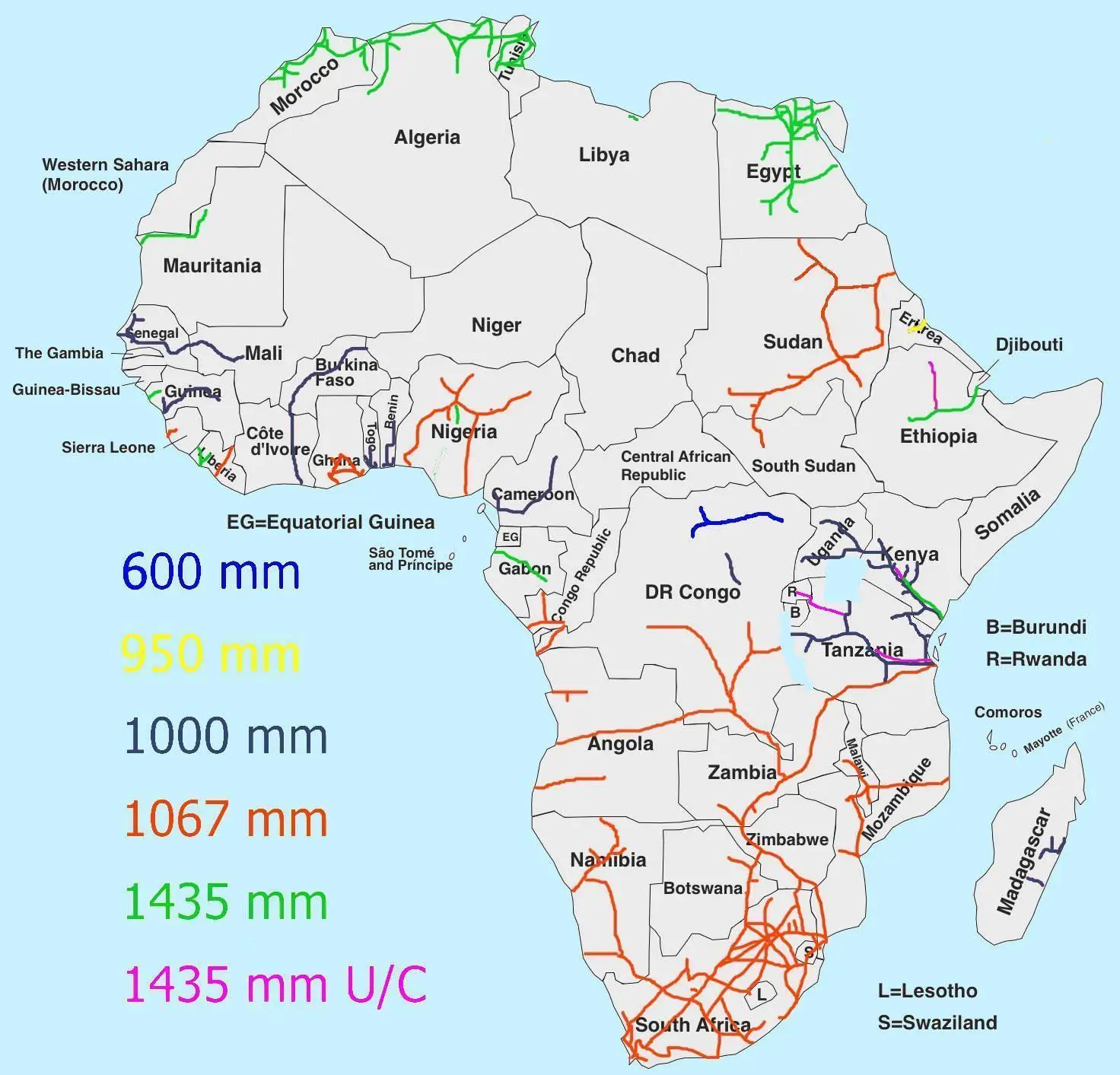
Click or tap the map to enlarge it.
Africa Railway Map Gauge: Key Takeaways
- Africa Railway Map Gauge is an essential tool for understanding the railway network across the African continent.
- The map provides information on different railway gauges used in various countries in Africa.
- Understanding railway gauges is crucial for efficient transportation and trade within Africa.
- Exploring the history and unique insights related to the Africa Railway Map Gauge helps in appreciating its significance.
History
The history of railway development in Africa dates back to the colonial era when European powers sought to exploit the continent’s resources and establish efficient trade routes. The construction of railways played a vital role in connecting inland regions with ports and facilitating the transportation of goods and people.
Due to varying historical influences and geographical factors, different railway gauges were adopted across Africa. A railway gauge refers to the distance between the two tracks of a railway line. It determines the width of the tracks and affects interoperability between railway networks.
Unique Insights
The Africa Railway Map Gauge helps in understanding some unique insights about the continent’s railway system:
- Colonial Legacy: The colonial powers, including Britain, France, Germany, and Belgium, favored their respective railway gauge standards, leading to differences and challenges in railway connectivity.
- Meter Gauge Dominance: The meter gauge, with a track width of approximately one meter, became widely used across Western, Eastern, and Southern Africa due to the influence of British colonial rule.
- Cape Gauge in Southern Africa: The Cape gauge, with a track width of 1,067mm, was adopted in Southern Africa, including South Africa, Botswana, Namibia, and Zimbabwe, due to historical factors and the influence of Cape Colony’s railways.
- Narrow Gauge in East Africa: In East Africa, including Kenya, Tanzania, and Uganda, a narrow gauge of 1,000mm was chosen for railway construction, mainly influenced by British colonial rule and geographical considerations.
- Standard Gauge Initiative: In recent years, there has been a push for standardizing railway gauges across Africa through the Standard Gauge Railway (SGR) initiative. This aims to improve connectivity and facilitate regional trade and integration.
Table of Relevant Facts
| Country | Railway Gauge |
|---|---|
| Algeria | Standard Gauge (1435mm) |
| Nigeria | Standard Gauge (1435mm) |
| South Africa | Cape Gauge (1067mm) |
| Kenya | Meter Gauge (1000mm) |
| Tanzania | Meter Gauge (1000mm) |
| Ethiopia | Standard Gauge (1435mm) |
| Ghana | Meter Gauge (1000mm) |
Frequently Asked Questions (FAQ)
1. What is a railway gauge?
Railway gauge refers to the distance between the two tracks of a railway line. It determines the width of the tracks and affects interoperability between different railway networks.
2. Why are there different railway gauges in Africa?
During the colonial era, European powers influenced the railway development in Africa, leading to the adoption of different railway gauges based on their preferences and historical factors.
3. How does railway gauge affect transportation and trade?
Railway gauge impacts the compatibility of trains and infrastructure. If railways have different gauges, transshipment of goods and passengers can become necessary at the point of gauge change, which increases costs and time.
4. What is the Standard Gauge Railway (SGR) initiative?
The Standard Gauge Railway (SGR) initiative aims to standardize railway gauges across Africa, promoting regional integration, trade, and economic development. It involves the construction of new standard gauge railway lines and upgrading existing lines.
5. Which countries in Africa use the Cape gauge?
Countries in Southern Africa, such as South Africa, Botswana, Namibia, and Zimbabwe, use the Cape gauge with a track width of 1,067mm.
6. Which countries in Africa use the meter gauge?
The meter gauge is widely used in Western, Eastern, and Southern African countries, including Kenya, Tanzania, Uganda, and Ghana. The track width of the meter gauge is approximately one meter.
7. How is railway gauge related to colonial history?
Colonial powers played a significant role in the development of railways in Africa. The differing railway gauges in African countries reflect the preferences and influences of various colonial powers during their occupation.