Alabama Population Map
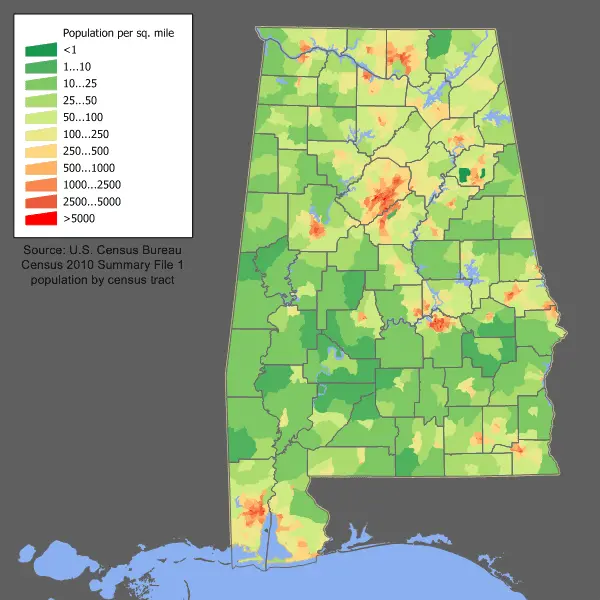
Click or tap the map to enlarge it.
Alabama Population Map – An Expert Cartographer’s Guide
Key Takeaways
- Understanding the population distribution in Alabama is essential for various planning and development purposes.
- Alabama’s population has been steadily growing over the years, with certain areas experiencing more significant growth than others.
- A population map visually represents the population density and distribution across different regions of Alabama.
- By analyzing the Alabama Population Map, we can identify areas with high population concentration and areas that need further development.
- Utilizing this map can help in making informed decisions regarding resource allocation and infrastructure development within the state.
History
The Alabama Population Map provides valuable insights into the population dynamics of Alabama over the years. The history of the state’s population growth and distribution can be traced back to its early settlement and subsequent periods of development.
Since Alabama’s admission to the Union in 1819, its population has consistently shown an upward trend. The early population growth was primarily driven by migration from other states and the expansion of cotton cultivation, which created a high demand for labor.
During the late 19th and early 20th centuries, the industrial revolution had a profound impact on Alabama’s population. The growth of industries, such as coal mining and steel production, attracted large numbers of people to areas like Birmingham and the surrounding regions.
Over time, the population distribution in Alabama has undergone significant changes. Urbanization and suburbanization have led to the concentration of people in cities and towns, while rural areas have experienced a decline in population. These shifts have been influenced by factors such as economic opportunities, infrastructure development, and changing societal preferences.
Unique Insights
Studying the Alabama Population Map reveals several unique insights about the state’s population patterns:
- The majority of Alabama’s population is concentrated in the central and northern parts of the state, with cities like Birmingham, Huntsville, and Montgomery having the highest population densities.
- Coastal areas, such as Mobile and Gulf Shores, have also experienced significant growth due to their attractiveness as tourist destinations.
- The Black Belt region in the southern part of Alabama has a historically significant African American population, contributing to the state’s cultural diversity.
- In recent years, certain rural areas have seen a decline in population due to factors like job opportunities, lack of essential amenities, and limited access to healthcare and education facilities.
- Population growth in Alabama can be attributed to a combination of natural increases (births exceeding deaths) and net migration.
Table of Relevant Facts
| Year | Population | Notable Event |
|---|---|---|
| 1819 | 127,901 | Alabama admitted to the Union as the 22nd state. |
| 1900 | 1,828,697 | Industrialization boom begins, attracting migrants to cities like Birmingham. |
| 1950 | 3,061,743 | Alabama experiences growth during the post-World War II period. |
| 2010 | 4,779,745 | Population reaches an all-time high, with significant growth in urban areas. |
Frequently Asked Questions (FAQ)
1. Why is understanding the population distribution in Alabama important?
Understanding the population distribution in Alabama is crucial for planning purposes. It helps in allocating resources, determining infrastructure needs, and making informed decisions regarding development and public services.
2. What factors have contributed to the growth of Alabama’s population?
Factors such as natural increase (births exceeding deaths) and net migration, both domestic and international, have contributed to the growth of Alabama’s population over the years.
3. Which cities in Alabama have the highest population densities?
Birmingham, Huntsville, and Montgomery are among the cities in Alabama with the highest population densities. These areas have experienced significant urbanization and economic growth.
4. Why have certain rural areas in Alabama seen a decline in population?
Certain rural areas in Alabama have witnessed a decline in population due to factors like limited job opportunities, lack of essential amenities, and limited access to healthcare and education facilities. This has led to migration towards more developed urban areas.
5. Are there any notable patterns in the population distribution along the coast?
Coastal areas, such as Mobile and Gulf Shores, have experienced significant growth due to their attractiveness as tourist destinations. Population density along the coast is higher compared to some rural areas.
6. What is the significance of the Black Belt region in Alabama?
The Black Belt region in Alabama has a historically significant African American population. It has played a crucial role in shaping the state’s cultural diversity and heritage.
7. How has Alabama’s population changed over time?
Since its admission to the Union in 1819, Alabama’s population has steadily grown. The population distribution has shifted from primarily rural to more urban and suburban areas due to various factors such as industrialization and economic opportunities.