Bangladesh Regions Map
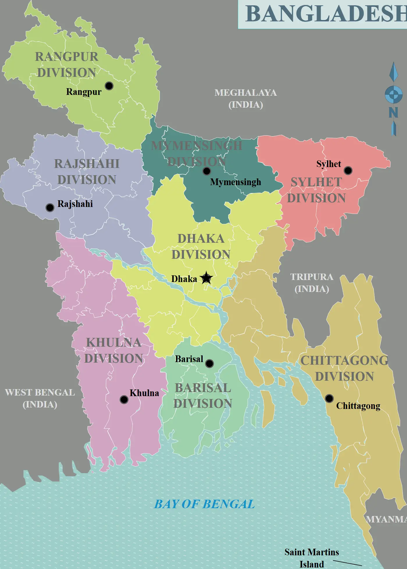
Click or tap the map to enlarge it.
Key Takeaways
- Bangladesh consists of eight administrative divisions.
- Each division is further divided into districts, upazilas, and unions.
- The regions in Bangladesh have distinct geographical and cultural characteristics.
- The map of Bangladesh provides a visual representation of its administrative divisions.
History
Bangladesh, officially known as the People’s Republic of Bangladesh, is a country located in South Asia. It gained independence from West Pakistan on March 26, 1971, after a nine-month-long liberation war.
The country is divided into eight administrative divisions: Barisal, Chittagong, Dhaka, Khulna, Mymensingh, Rajshahi, Rangpur, and Sylhet.
Unique Insights
1. The Barisal division is known for its vast river network, lush green paddy fields, and the beautiful Sundarbans mangrove forest.
2. Chittagong division is home to the second largest city in Bangladesh, Chittagong, which is a significant seaport and industrial hub.
3. Dhaka, the capital city, is located in the Dhaka division. It is the political, economic, and cultural center of the country.
4. Khulna division is famous for the Sundarbans, the largest mangrove forest in the world and a UNESCO World Heritage Site.
5. Mymensingh division is known for its agricultural significance, with vast stretches of fertile land and farming communities.
6. Rajshahi division is recognized for its historical and archaeological heritage, including the famous Puthia Temple Complex.
7. Rangpur division is characterized by its agricultural produce, including rice, jute, tea, and sugarcane.
8. Sylhet division is famous for its picturesque landscapes, tea gardens, and the famous Jaflong Stone Quarry.
Table of Relevant Facts
| Division | Capital | Area |
|---|---|---|
| Barisal | Barisal | 13,297 km² |
| Chittagong | Chittagong | 33,771 km² |
| Dhaka | Dhaka | 31,119 km² |
| Khulna | Khulna | 22,285 km² |
| Mymensingh | Mymensingh | 10,584 km² |
| Rajshahi | Rajshahi | 18,174 km² |
| Rangpur | Rangpur | 16,317 km² |
| Sylhet | Sylhet | 12,596 km² |
Frequently Asked Questions (FAQ)
1. How many administrative divisions does Bangladesh have?
Bangladesh consists of eight administrative divisions.
2. What is the capital of Dhaka division?
The capital of Dhaka division is Dhaka city.
3. Which division is known for the Sundarbans mangrove forest?
The Khulna division is known for the Sundarbans mangrove forest.
4. What is the historical significance of Rajshahi division?
Rajshahi division is recognized for its historical and archaeological heritage, including the famous Puthia Temple Complex.
5. What is the area of Chittagong division?
Chittagong division has an area of 33,771 km².
6. Which division is famous for its tea gardens?
Sylhet division is famous for its picturesque landscapes and tea gardens.
7. How many districts are there in Bangladesh?
Bangladesh is divided into a total of 64 districts.