Banten Province Map
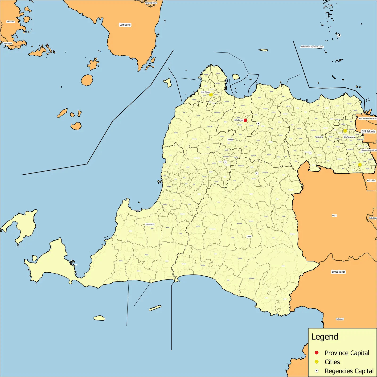
Click or tap the map to enlarge it.
Banten Province Map: Exploring the Beauty of Indonesia
Key Takeaways
- Banten Province is located in the western part of Java Island, Indonesia.
- The province is known for its diverse natural landscapes, rich history, and cultural heritage.
- Banten Province offers a wide range of tourist attractions, including pristine beaches, volcanic mountains, and historical sites.
- The map of Banten Province helps visitors navigate and explore the various destinations within the province.
- By using the Banten Province map, travelers can plan their itineraries and make the most of their trip to this beautiful region.
History of Banten Province
Banten Province, originally known as Bantam, has a fascinating history that dates back centuries. It was a powerful trading center and one of the most important ports in Southeast Asia during the early days of international trade. The province was also a significant cultural and political hub, ruled by the Sultanate of Banten.
The Sultanate of Banten was established in the 16th century and flourished for several centuries. It had diplomatic relations with various European powers, including the Dutch East India Company. However, in the 18th century, the Dutch gradually gained control over the region and ultimately dissolved the sultanate.
Unique Insights about Banten Province
Banten Province offers a unique blend of natural beauty, history, and cultural diversity. Here are some insights about the province:
- The Ujung Kulon National Park, located in Banten Province, is a UNESCO World Heritage Site and home to the critically endangered Javan rhinoceros.
- Anyer Beach, popular among tourists, is a prime spot for beautiful sunsets.
- Banten is renowned for its traditional arts and crafts, such as the intricate woodcarvings and exquisite batik fabrics.
- Pulau Umang, a beautiful island in Banten, offers stunning natural landscapes and luxurious resorts.
- Serang, the capital city of Banten Province, is a vibrant urban center with modern amenities and historical landmarks.
Table: Relevant Events in Banten Province
| Year | Event |
|---|---|
| 1526 | The Sultanate of Banten is established. |
| 1619 | The Dutch East India Company builds a fort in Banten. |
| 1808 | The Dutch dissolve the Sultanate of Banten. |
| 1960 | Banten becomes part of the province of West Java. |
| 2000 | Banten is established as a separate province. |
Frequently Asked Questions (FAQ)
1. What are some popular tourist attractions in Banten Province?
Banten Province is home to various popular tourist attractions, such as:
- Pulau Umang
- Ujung Kulon National Park
- Anyer Beach
- Old Banten
2. How can I navigate through Banten Province using the map?
The Banten Province map provides detailed information about roads, highways, and landmarks, making it easy to navigate and plan your journey within the province.
3. Is Banten Province safe for tourists?
Yes, Banten Province is generally safe for tourists. However, as with any destination, it is always advisable to take necessary precautions and follow local guidelines.
4. Are there any cultural festivals in Banten Province?
Yes, Banten Province celebrates various cultural festivals throughout the year. Some of the notable festivals include the Seren Taun festival and the Bantenese Mask Festival.
5. Can I find accommodations in Banten Province?
Yes, Banten Province offers a wide range of accommodations, including luxury resorts, budget hotels, and guesthouses, to cater to different preferences and budgets.
6. Are there any historical sites in Banten Province?
Yes, Banten Province is rich in historical sites. Some of the must-visit historical landmarks include the Old Banten Fortress and the Great Mosque of Banten.
7. How can I reach Banten Province?
Banten Province is easily accessible by air, with Soekarno-Hatta International Airport being the main gateway. Alternatively, you can also reach the province by train or road.