Barcelona Districts Map
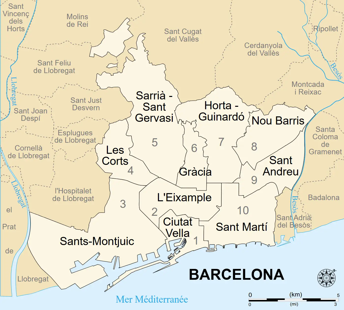
Click or tap the map to enlarge it.
Key Takeaways
- Barcelona Districts Map showcases the diverse neighborhoods in the city.
- The map helps tourists and locals navigate and explore Barcelona efficiently.
- Understanding the history and unique insights of each district enhances the overall experience.
Barcelona Districts Map: Unveiling the Rich History
Barcelona, the capital of Catalonia, is a vibrant city known for its unique blend of history, culture, and architecture. Exploring this magnificent city becomes much more convenient with the Barcelona Districts Map, as it allows visitors to uncover the enchanting neighborhoods that shape its identity.
Unique Insights into Barcelona’s Districts
1. Ciutat Vella
Ciutat Vella, meaning “Old City” in Catalan, is the historic heart of Barcelona. It comprises four distinct neighborhoods – El Raval, Barri Gòtic, El Born, and Barceloneta. Each neighborhood possesses its own charm and character.
2. Eixample
Eixample, meaning “Expansion” in Catalan, is an impressive district famous for its grid-like layout and modernist architecture. Noteworthy landmarks include Antoni Gaudí’s iconic masterpiece, Sagrada Família, and the luxurious Passeig de Gràcia.
3. Gràcia
Gràcia is a bohemian neighborhood known for its narrow streets, lively squares, and cozy cafes. It offers a more relaxed atmosphere, attracting artists, students, and young professionals alike.
4. Sants-Montjuïc
Sants-Montjuïc is home to Montjuïc Hill, offering breathtaking panoramic views of the city. It also houses various attractions including the Magic Fountain, Olympic Stadium, and Montjuïc Castle.
5. Sarrià-Sant Gervasi
Sarrià-Sant Gervasi is an upscale district known for its elegant streets, designer boutiques, and beautiful parks. It is a preferred residential area for many locals seeking tranquility within the city.
6. Les Corts
Les Corts is best known as the location of the famous Camp Nou stadium, home to FC Barcelona. It combines residential areas with commercial centers, providing a balanced urban environment.
7. Sant Martí
Sant Martí, located by the seaside, offers a more modern and industrial ambiance. This district has undergone extensive redevelopment, resulting in a vibrant neighborhood filled with technological innovation and cultural attractions.
History of Barcelona’s Districts
Understanding the historical background of each district enriches the exploration of Barcelona’s varied neighborhoods. Here is a table outlining some significant facts about the districts:
| District | Historical Facts |
|---|---|
| Ciutat Vella | – El Raval was Barcelona’s medieval red-light district. |
| Eixample | – It was designed in the late 19th century as part of the expansion plan called the Cerdà Plan. |
| Gràcia | – It used to be an independent village until it was incorporated into Barcelona in the late 19th century. |
| Sants-Montjuïc | – Montjuïc Hill played a significant role during the 1992 Olympic Games hosted by Barcelona. |
| Sarrià-Sant Gervasi | – The district was historically a separate town called Sarrià until it merged with Barcelona in 1921. |
| Les Corts | – Its name refers to the former agricultural fields located in this area. |
| Sant Martí | – It experienced rapid industrialization during the 19th and 20th centuries. |
Frequently Asked Questions (FAQ)
1. How can I access the Barcelona Districts Map?
You can find the Barcelona Districts Map online on various tourism websites or obtain a physical copy from local tourist information centers.
2. Which district is best for food enthusiasts?
Ciutat Vella, particularly the El Born neighborhood, is a gastronomic paradise with numerous local eateries and trendy restaurants serving both traditional and innovative cuisine.
3. Are all districts easily accessible by public transportation?
Yes, Barcelona has an efficient public transportation system including the metro, buses, and trams, ensuring convenient access to all districts.
4. Can I explore the districts on foot?
Absolutely! Walking is a great way to immerse yourself in Barcelona’s vibrant streets and discover hidden gems within each district.
5. Are there any cultural events or festivals specific to each district?
Yes, each district in Barcelona often hosts its own local festivals and cultural events. Check the local event calendars to see if any coincide with your visit.
6. Is it safe to visit all districts of Barcelona?
Barcelona is considered a safe city overall. However, it is always advisable to take common precautions and be aware of your surroundings, especially in crowded tourist areas.
7. Which district is known for its nightlife?
Some popular nightlife areas include El Raval, El Born, and Gràcia, which offer a vibrant scene with various bars, clubs, and live music venues.