Rivers of North Bengal Map
Click or tap the map to enlarge it.
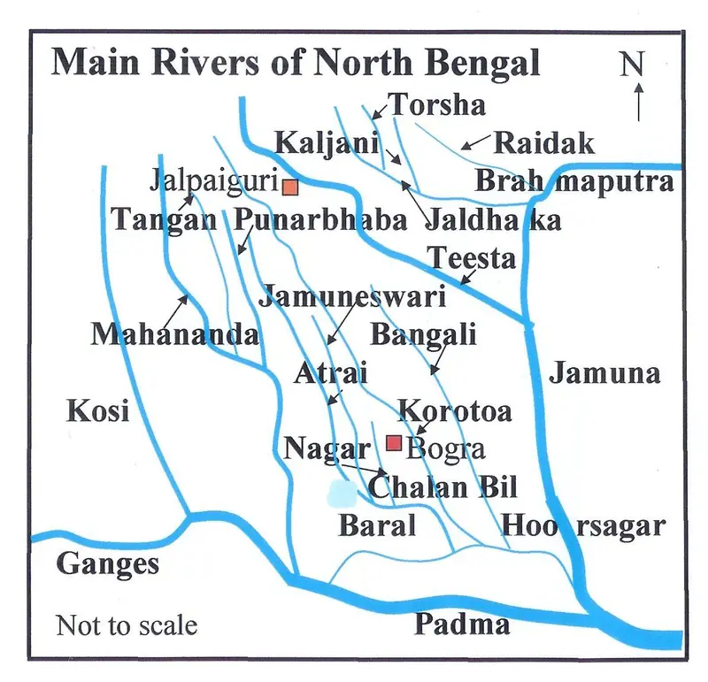
This diagram labels the main rivers of North Bengal and neighbouring northern Bangladesh, including the Teesta, Jaldhaka, Torsha, Raidak, Mahananda and Karatoya. It is a schematic, not a survey map: the aim is to show how the rivers relate to each other rather than to give exact positions.
The pattern is characteristic of a region where rivers descend from the eastern Himalaya and spread across a very flat plain before joining the Brahmaputra and Ganges systems.
Rivers that change their minds
The rivers of the Duars and the Bengal plain carry heavy loads of silt from steep Himalayan catchments. When they reach flat ground they slow down, drop the sediment and shift channels, which is why the region is crossed by braided streams and abandoned channels. The Teesta is the best-known example. Records suggest that before a major flood in 1787 it flowed south to join the Ganges system, and afterwards it turned east toward the Brahmaputra, known in Bangladesh as the Jamuna.
That change of course reshaped drainage across northern Bengal and left older channels, such as the Karatoya and Punarbhaba, as smaller rivers.
Why the map matters today
The Teesta rises in Sikkim, runs for roughly 400 kilometres and supports irrigation in both West Bengal and Bangladesh through barrages such as Gajoldoba in India and Dalia in Bangladesh. Sharing its dry-season flow has been a long-running subject of negotiation between the two countries. A river diagram of this kind helps readers see how many streams cross the border and why water planning in the region is a shared concern.
Key facts
| River | Note |
|---|---|
| Teesta | Rises in Sikkim; joins the Brahmaputra (Jamuna) in Bangladesh |
| Jaldhaka | Flows from the Bhutan and Sikkim border area through the Duars |
| Torsha | Descends from the Himalaya through Bhutan into the Duars |
| Mahananda | Rises near Darjeeling and flows toward the Ganges |
| Brahmaputra / Jamuna | Known as the Jamuna in Bangladesh |
Questions about this map
What is North Bengal?
North Bengal is the northern part of West Bengal in India, including the Darjeeling hills, the Duars and the plains around Siliguri and Cooch Behar.
Is this map to scale?
No. It is a schematic diagram that shows relationships between rivers. Use an official survey or an atlas when you need distances.
Why do the rivers shift so often?
Their steep upper courses carry large amounts of sediment, and on the flat plain the water spreads out, drops the silt and can change course in a flood.