Capitol Hill Map
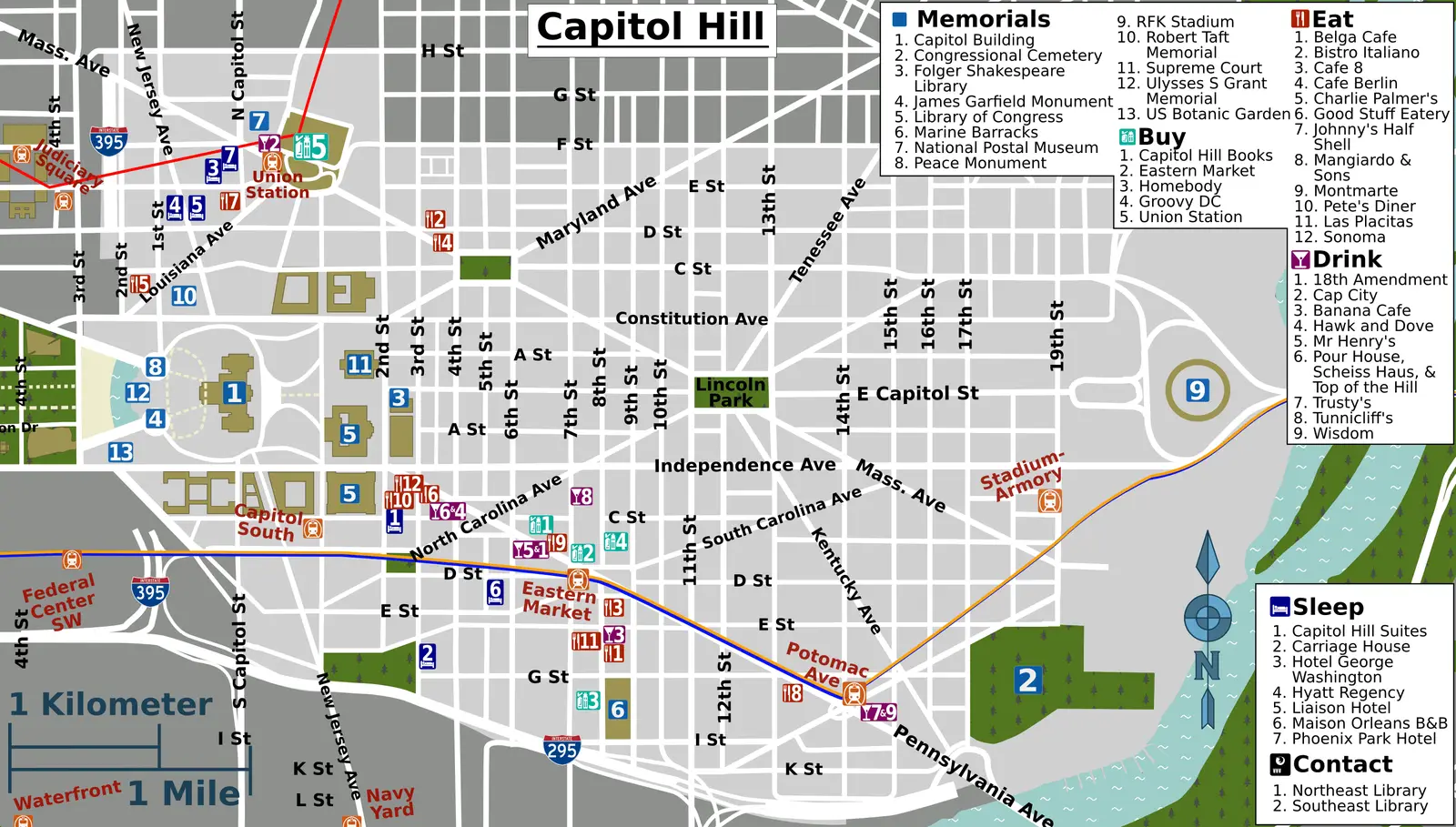
Click or tap the map to enlarge it.
Key Takeaways
- The Capitol Hill Map is a detailed representation of the Capitol Hill area in Washington, D.C.
- It provides valuable information about the various landmarks, government buildings, and points of interest in the neighborhood.
- Cartographers expertly design the map to be highly informative, visually appealing, and easy to navigate.
- The map serves as a useful tool for tourists, residents, and government officials to explore and understand Capitol Hill.
History of the Capitol Hill Map
The Capitol Hill Map has a rich history that dates back to the early days of Washington, D.C. The neighborhood of Capitol Hill has been an important political and cultural center since the city’s inception.
As the United States capital, Washington, D.C., was planned and designed, the need for a detailed map became apparent. Surveyors and cartographers worked diligently to accurately depict the layout of the city, including the prominent Capitol Hill area.
Throughout the years, the Capitol Hill Map has evolved to reflect the changing landscape and the growth of the city. With each new construction, landmark, and development, the map has been updated to provide an up-to-date representation of Capitol Hill.
Unique Insights about the Capitol Hill Map
1. Historical Significance: The Capitol Hill Map not only showcases the current state of the neighborhood but also provides insights into its historical significance. It highlights iconic landmarks such as the United States Capitol, Supreme Court, and Library of Congress, which are steeped in history and have played important roles in shaping the nation.
2. Navigation Made Easy: Cartographers pay special attention to the design and layout of the Capitol Hill Map, ensuring that it is user-friendly and easy to navigate. Visitors can easily find their way to various attractions, parks, and points of interest, thanks to clear labeling and intuitive symbols.
3. Detailed Landmarks: The map offers detailed representations of important landmarks within Capitol Hill, such as the Marine Barracks, Eastern Market, and the Folger Shakespeare Library. This level of detail allows users to plan their visit effectively and make the most out of their time in the neighborhood.
4. Metro and Transportation Information: In addition to landmarks, the Capitol Hill Map provides valuable information about nearby metro stations, bus routes, and bicycle lanes. This feature helps both locals and tourists navigate the area using public transportation.
5. Parks and Open Spaces: The Capitol Hill area is known for its beautiful parks and open spaces. The map highlights these green areas, including Lincoln Park, Garfield Park, and Stanton Park. This information allows visitors to plan outdoor activities and enjoy the natural beauty of the neighborhood.
Table of Relevant Facts
| Year | Event |
|---|---|
| 1791 | Capitol Hill area officially included in the original plan of Washington, D.C. |
| 1800 | United States government moves to Washington, D.C. |
| 1863 | Lincoln Park is established. |
| 1873 | Eastern Market building completed. |
| 1897 | The Library of Congress Thomas Jefferson Building opens to the public. |
| 1903 | United States Capitol dome completed. |
| 2010 | The Capitol Visitor Center opens beneath the U.S. Capitol. |
Frequently Asked Questions (FAQ)
-
How can I obtain a copy of the Capitol Hill Map?
The Capitol Hill Map is available at various visitor centers and tourist information booths in Washington, D.C. It can also be accessed online through official websites or downloaded as a digital copy.
-
Is the Capitol Hill Map available in multiple languages?
Yes, to accommodate international visitors, the Capitol Hill Map is often available in multiple languages, including English, Spanish, French, German, and Mandarin.
-
Is the Capitol Hill Map updated regularly?
Yes, the Capitol Hill Map is updated periodically to reflect any changes in the neighborhood. New landmarks, road closures, or attractions are incorporated into the map to provide accurate and current information.
-
Can I use the Capitol Hill Map for navigation purposes?
While the Capitol Hill Map is designed to assist with navigation, it is recommended to use GPS or navigation apps on smartphones for real-time directions and turn-by-turn guidance.
-
Are there any guided tours available using the Capitol Hill Map?
Yes, several guided tours of Capitol Hill utilize the map as a reference. These tours offer in-depth knowledge and insights into the landmarks and history of the area.
-
Can I provide feedback or suggest updates for the Capitol Hill Map?
Absolutely! Feedback and suggestions for the Capitol Hill Map are always welcomed. You can reach out to the official authorities responsible for the map’s development or submit feedback through their online platforms.
-
Is the Capitol Hill Map free of charge?
Yes, the Capitol Hill Map is typically available free of charge. It is considered a public resource to help visitors explore and enjoy the neighborhood.