Central India Agency Map
Click or tap the map to enlarge it.
**Key Takeaways:**
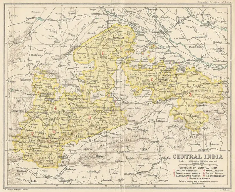
– The Central India Agency Map provides a detailed overview of the Central India Agency region during the British Raj.
– The map showcases the administrative divisions, major cities, rivers, and important landmarks within the Central India Agency.
– It is a valuable tool for historians, researchers, and enthusiasts interested in understanding the historical and geographical context of Central India.
– The map illustrates the extent of British colonial influence, particularly in terms of administrative control and infrastructure development.
– Exploring the Central India Agency Map can offer insights into the cultural, social, and political landscape of the region during the British rule.
History of the Central India Agency Map
The Central India Agency Map provides a snapshot of the Central India Agency, which was an administrative unit during the period of British colonial rule in India. This agency was created in 1854 to manage the territories under the British government’s control and ensure efficient governance.
The Central India Agency covered a vast area in central India, encompassing parts of present-day Madhya Pradesh, Chhattisgarh, and Maharashtra. The region was home to numerous princely states and was strategically significant for the British East India Company due to its rich natural resources and trade potential.
This map was created during the British Raj, with cartographers meticulously charting the various administrative divisions, major towns, rivers, and topographical features of the Central India Agency. It aimed to assist the British administrators in efficiently governing the region and facilitating communication and transportation networks.
Unique Insights
1. Geographical Divisions: The Central India Agency Map reveals the geographical diversity of the region, showcasing the Vindhya and Satpura mountain ranges, as well as the fertile plains of the Narmada and Tapti rivers. These geographical features played a significant role in shaping the history and development of the region.
2. Administrative Divisions: The map delineates the administrative divisions within the Central India Agency. It showcases the various princely states, such as Bhopal, Rewa, and Indore, and how they were interconnected within the British colonial administrative framework.
3. Development of Infrastructure: The map provides insights into the development of infrastructure during the British Raj. It highlights the presence of railways, major roads, and important towns, indicating the strategic focus on improving transportation networks for trade and governance purposes.
4. Cultural Significance: By examining the map, one can gain a deeper understanding of the cultural diversity and historical significance of the Central India Agency. The presence of ancient cities like Ujjain and historical landmarks like the Sanchi Stupa reflects the rich cultural heritage of the region.
5. Colonial Influence: The Central India Agency Map underscores the extent of British colonial influence in the region. It demonstrates the consolidation of British power through the establishment of administrative control and the integration of princely states into the larger colonial framework.
Table: Relevant Facts about Central India Agency
| Year | Key Event |
|——|———–|
| 1854 | Establishment of Central India Agency |
| 1881 | Creation of Central India Agency’s headquarters in Indore |
| 1905 | Merger of princely states of Bhopal and Indore into Central India Agency |
| 1911 | Central India Agency becomes a province |
| 1950 | Integration of Central India Agency into Madhya Pradesh |
Frequently Asked Questions (FAQ)
**1. What was the Central India Agency?**
The Central India Agency was an administrative unit during the British colonial rule in India. It encompassed parts of present-day Madhya Pradesh, Chhattisgarh, and Maharashtra.
**2. Which major cities were part of the Central India Agency?**
Some major cities included Bhopal, Indore, Jabalpur, Nagpur, and Ujjain.
**3. What was the purpose of the Central India Agency Map?**
The Central India Agency Map was created to aid British administrators in governing the region efficiently and to facilitate transportation and communication networks.
**4. What is the historical significance of the Central India Agency?**
The Central India Agency played a crucial role in the British colonial administration’s efforts to control and govern the vast territories of central India.
**5. Are the princely states marked on the map still present today?**
No, after India gained independence in 1947, the princely states were integrated into the newly formed Indian Union or reorganized into new administrative divisions.
**6. Is the Central India Agency Map relevant today?**
While the Central India Agency does not exist anymore, the map holds historical significance and provides insights into the region’s past.
**7. Where can I access the Central India Agency Map?**
You can access the Central India Agency Map in historical archives, libraries, or online repositories focused on cartography and historical maps.