Chikmagalur Tourist Map
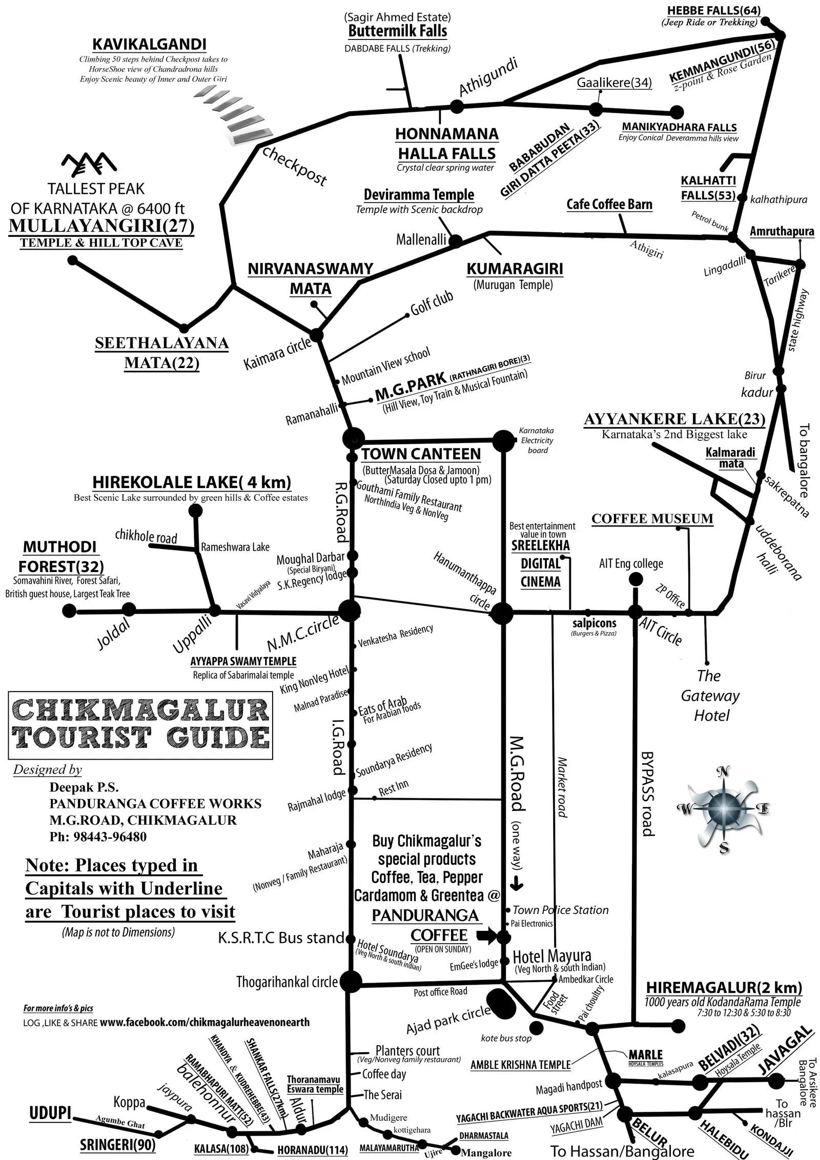
Click or tap the map to enlarge it.
Key Takeaways
- Chikmagalur, located in Karnataka, India, is a popular tourist destination known for its natural beauty and pleasant climate.
- The Chikmagalur Tourist Map serves as an essential guide for visitors, offering information on popular attractions, accommodations, transportation, and more.
- The map is designed to provide a convenient reference tool for exploring Chikmagalur’s scenic spots, historical landmarks, and cultural sites.
History
Chikmagalur, often referred to as the “Coffee Land” of Karnataka, has a rich and fascinating history. The region was ruled by several dynasties, including the Hoysalas and the famous Vijayanagara Empire. In the 17th century, Chikmagalur became a part of the Kingdom of Mysore under the Wodeyar dynasty.
The town gained prominence during the colonial era when the British introduced coffee plantations in the region. The lush hills of Chikmagalur provided the perfect habitat for growing coffee, and soon it became a significant center for coffee production in India.
Today, Chikmagalur is not only known for its coffee but also for its astonishing natural beauty and tourism potential. The Chikmagalur Tourist Map plays a vital role in showcasing the area’s attractions and serving as a tool for tourists to navigate their way through this mesmerizing destination.
Unique Insights
1. Serene Hill Stations: Chikmagalur is home to picturesque hill stations like Baba Budangiri, Mullayanagiri, and Kemmanagundi. These tranquil spots offer breathtaking views, enjoyable trekking trails, and an escape from the city’s hustle and bustle.
2. Ancient Temples and Forts: The map highlights ancient temples like Sringeri Sharada Peetham, Horanadu Annapoorneshwari Temple, and Belavadi Veeranarayana Temple. Additionally, it features historical forts like Halebeedu and Kalhatti Giri Fort, showcasing Chikmagalur’s rich cultural heritage.
3. Coffee Plantations: Chikmagalur’s coffee plantations are a major attraction for visitors. The map provides information on various plantations, allowing tourists to explore and learn about the coffee-making process, while enjoying the aroma and taste of freshly brewed coffee.
4. Waterfalls and Nature Reserves: Chikmagalur boasts stunning waterfalls such as Hebbe Falls, Manikyadhara Falls, and Jhari Falls. The map helps tourists discover these refreshing natural wonders, along with wildlife sanctuaries like Bhadra Wildlife Sanctuary, where one can witness diverse flora and fauna.
Table of Relevant Facts
| Year | Event |
|---|---|
| 14th century | Rule of Hoysalas dynasty in Chikmagalur |
| 15th century | Chikmagalur conquered by the Vijayanagara Empire |
| 17th century | Chikmagalur became a part of the Kingdom of Mysore |
| 19th century | Introduction of coffee plantations by the British |
Frequently Asked Questions (FAQ)
1. How do I reach Chikmagalur?
To reach Chikmagalur, you can take a flight to Mangalore International Airport or Kempegowda International Airport in Bengaluru. From there, you can hire a taxi or take a bus to Chikmagalur.
2. What are the best times to visit Chikmagalur?
The best time to visit Chikmagalur is from September to March when the weather is pleasant, and the region is lush green. Avoid visiting during the monsoon season (June to August) as heavy rainfall may hinder outdoor activities.
3. Are there accommodation options in Chikmagalur?
Yes, Chikmagalur offers a wide range of accommodation options, including luxury resorts, homestays, and guesthouses. Ensure to book in advance, especially during peak tourist seasons, to secure your preferred choice.
4. What are the must-visit attractions in Chikmagalur?
Some of the must-visit attractions in Chikmagalur include Mullayanagiri Peak, Baba Budangiri Hills, Bhadra Wildlife Sanctuary, and Kemmanagundi Hill Station.
5. Is it safe to trek in Chikmagalur?
Trekking in Chikmagalur is generally safe; however, it is advised to go in groups and hire experienced guides. Follow safety precautions, carry essentials like water, snacks, and first aid kits, and inform someone about your trekking plans for added security.
6. Can I explore Chikmagalur in one day?
While it is possible to visit a few popular attractions in Chikmagalur in one day, it is recommended to spend at least 2-3 days to fully experience the beauty and serenity of the place.
7. Which is the nearest city to Chikmagalur?
The nearest major city to Chikmagalur is Mangalore, which is approximately 150 kilometers away. Bengaluru, the capital city of Karnataka, is around 245 kilometers from Chikmagalur.