First European Map of Tenochtitlan
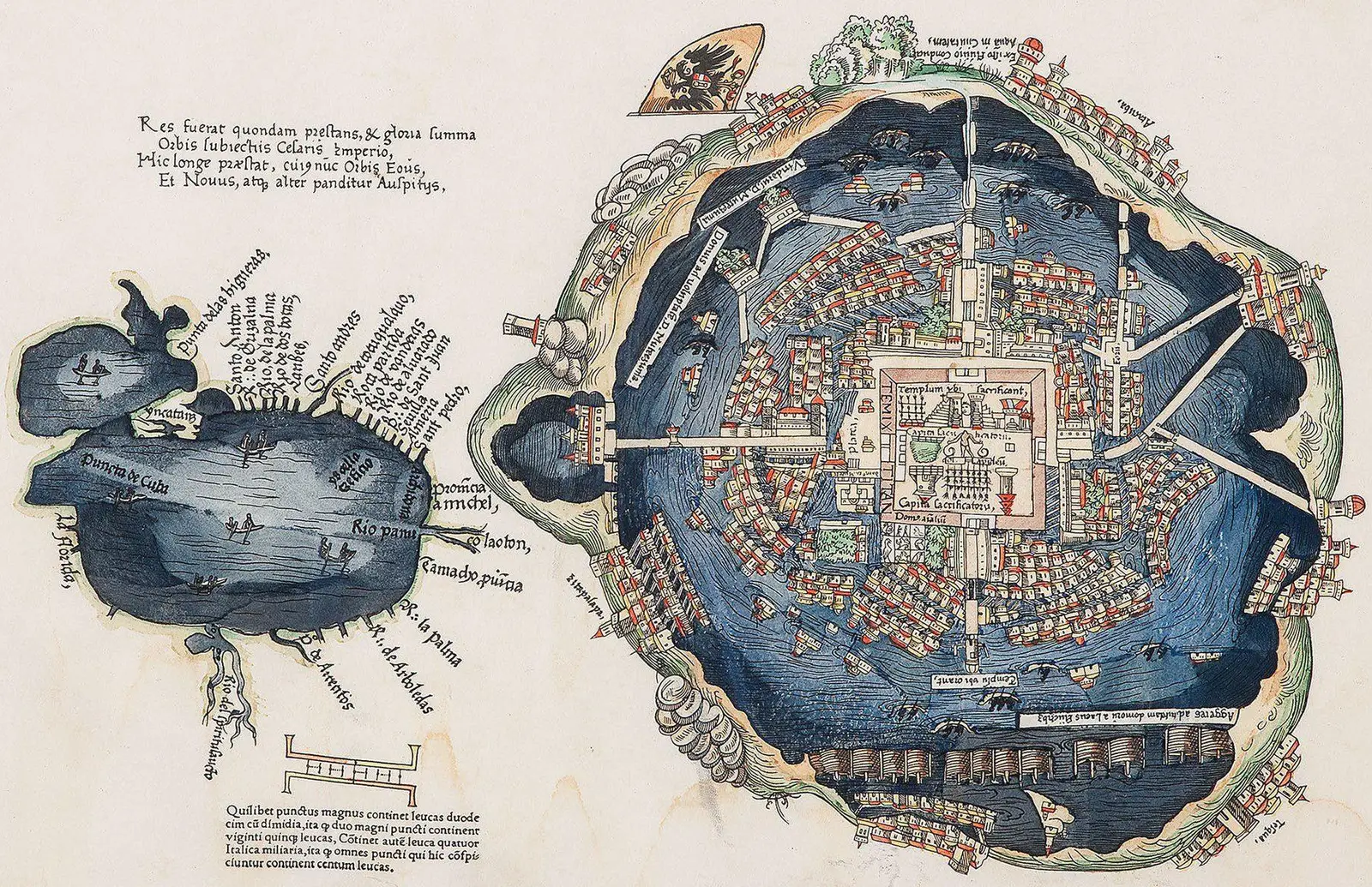
Click or tap the map to enlarge it.
First European Map Of Tenochtitlan – A Historical Cartographic Masterpiece
Key Takeaways:
- The first European map of Tenochtitlan provides valuable insights into the ancient city’s layout and architecture.
- This map was created by Hernán Cortés’ cartographer during the Spanish conquest of Mexico.
- It showcases Tenochtitlan’s unique infrastructure, including causeways, canals, and grand temples.
- The map serves as an important historical document, enabling researchers to uncover the city’s cultural and political aspects.
History
Tenochtitlan, the capital city of the Aztec Empire, was founded in 1325 on an island in the middle of Lake Texcoco, in present-day Mexico. It flourished as a vibrant and powerful city, with an intricate network of canals and causeways connecting various parts of the city. The grandeur of Tenochtitlan impressed the Spanish conquistadors, who sought to document and understand the city’s layout.
During the Spanish conquest of Mexico, Hernán Cortés, the Spanish conquistador, sent a team of explorers and cartographers to create maps of the conquered territories. Among them was an anonymous cartographer who meticulously surveyed and created the first European map of Tenochtitlan.
Unique Insights
The first European map of Tenochtitlan provides unique insights into the city’s architecture, landmarks, and infrastructure. It reveals a well-organized city divided into districts, with each district having its own temple complex, marketplaces, and public spaces.
The most notable aspect of Tenochtitlan was its network of canals, often compared to Venice. The map highlights the aqueducts and causeways that connected the various parts of the city, allowing efficient transportation and trade.
The map also showcases the grand temples, including the Templo Mayor, the central religious and political center of the Aztec Empire. This temple served as a focal point for ceremonies, rituals, and sacrifices.
Table of Relevant Facts
| Fact | Date |
|---|---|
| Tenochtitlan founded | 1325 |
| Map created by Cortés’ cartographer | 1524 |
| Spanish conquest of Tenochtitlan | 1521 |
| Templo Mayor construction begins | 1375 |
| City destroyed by the Spanish | 1521 |
Frequently Asked Questions (FAQ)
1. Who created the first European map of Tenochtitlan?
The first European map of Tenochtitlan was created by an anonymous cartographer, under the orders of Hernán Cortés during the Spanish conquest of Mexico.
2. When was the map created?
The map was created in 1524.
3. What does the map reveal about Tenochtitlan?
The map reveals the city’s layout, architecture, canals, causeways, and grand temples, providing valuable insights into the infrastructure of the ancient city.
4. How does the map contribute to our understanding of Tenochtitlan?
The map serves as an important historical document, enabling researchers to study and uncover various aspects of Tenochtitlan’s cultural, political, and architectural features.
5. What was the significance of the Templo Mayor?
The Templo Mayor was the central religious and political center of the Aztec Empire. It played a crucial role in ceremonies, rituals, and sacrifices.
6. When was Tenochtitlan founded?
Tenochtitlan was founded in 1325.
7. When was Tenochtitlan destroyed?
Tenochtitlan was destroyed by the Spanish in 1521.
External Links:
LSI Keywords: First European map of Tenochtitlan, Tenochtitlan layout, Tenochtitlan canals, Tenochtitlan causeways, Tenochtitlan temples, Spanish conquest of Mexico, Hernán Cortés, Aztec Empire, Templo Mayor