Former Yugoslavia Map
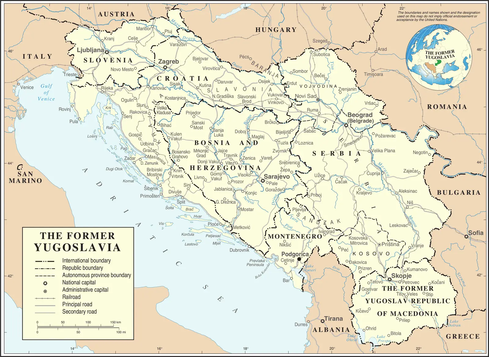
Click or tap the map to enlarge it.
Former Yugoslavia Map
Key Takeaways
- The Former Yugoslavia Map represents the region’s complex history and geopolitical changes.
- It showcases seven countries that emerged after the disintegration of Yugoslavia.
- Understanding the map helps in comprehending cultural, ethnic, and political dynamics in the Balkans.
- The Former Yugoslavia Map is an invaluable resource for historians, geopolitical experts, and travelers interested in the region.
History of Former Yugoslavia
The Former Yugoslavia, officially known as the Socialist Federal Republic of Yugoslavia, existed from 1945 to 1992. The country consisted of six republics and several autonomous provinces.
Yugoslavia was formed after World War I and included Slovenia, Croatia, Bosnia and Herzegovina, Serbia, Montenegro, and Macedonia. In 1945, Josip Broz Tito, the leader of the Yugoslav Partisans, established a socialist federation that aimed to unite different ethnic and religious groups.
After Tito’s death in 1980, tensions between different regions and ethnicities grew, ultimately leading to a series of violent conflicts in the early 1990s. The country disintegrated, and various independent nations emerged on the Former Yugoslavia Map.
Unique Insights
- The Former Yugoslavia Map illustrates how complex historical, cultural, and political factors contributed to the disintegration of the country.
- Geographically, the Balkan Peninsula plays a crucial role in understanding the region’s dynamics, with mountainous terrains and diverse landscapes.
- The map showcases the diversity of languages, religions, and ethnicities within the former Yugoslav territories.
- Slovenia, Croatia, Bosnia and Herzegovina, Serbia, Montenegro, Kosovo, and North Macedonia are the independent countries that emerged after the breakup.
- The internal struggles and conflicts between different ethnic and nationalist groups shaped the political boundaries portrayed on the map.
Relevant Facts about Former Yugoslavia
| Year | Event |
|---|---|
| 1945 | Formation of Socialist Federal Republic of Yugoslavia with six republics. |
| 1991 | Slovenia and Croatia declare independence. |
| 1992 | Bosnia and Herzegovina declares independence. |
| 1992 | Montenegro and Macedonia formally declare independence. |
| 1999 | NATO bombing campaign in response to the conflict in Kosovo. |
| 2006 | Montenegro holds a referendum to become an independent nation. |
| 2019 | North Macedonia formally changes its name from Macedonia. |
Frequently Asked Questions (FAQ)
1. What caused the breakup of Yugoslavia?
The breakup of Yugoslavia was primarily caused by deep-rooted ethnic and nationalist tensions that were reignited after the death of Tito and the collapse of communism.
2. How many countries emerged after the disintegration?
Seven countries emerged after the disintegration of Yugoslavia: Slovenia, Croatia, Bosnia and Herzegovina, Serbia, Montenegro, Kosovo, and North Macedonia.
3. What are the major languages spoken in the region?
The major languages spoken in the former Yugoslav territories include Slovene, Croatian, Bosnian, Serbian, Montenegrin, Albanian, and Macedonian.
4. Is the map important for travelers?
Yes, the Former Yugoslavia Map is essential for travelers to understand the region’s history, cultural diversity, and geopolitical changes.
5. Which country was the first to declare independence?
Slovenia was the first country to declare independence from Yugoslavia in 1991.
6. How did the Yugoslav Wars affect the region?
The Yugoslav Wars resulted in large-scale violence, displacement of populations, and the creation of new independent nations. It dramatically reshaped the geopolitical landscape of the Balkans.
7. Is the Former Yugoslavia Map internationally recognized?
Yes, the borders portrayed on the Former Yugoslavia Map are internationally recognized, and the countries are members of the United Nations and other international organizations.