Gloucestershire 1832 Map
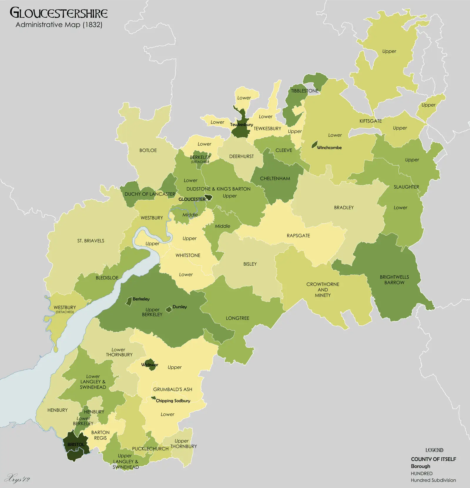
Click or tap the map to enlarge it.
Gloucestershire 1832 Map – The Historical World Map
Key Takeaways
- The Gloucestershire 1832 Map showcases the region’s historical boundaries and geographical features during the early 19th century.
- It provides valuable insights into the social, political, and cultural landscape of Gloucestershire at that time.
- The map serves as a valuable resource for historians, geographers, and enthusiasts interested in exploring the county’s rich heritage.
- By comparing the map with the present-day landscape, one can observe how Gloucestershire has evolved and changed over time.
- Gloucestershire has a diverse topography, including the iconic Cotswold Hills and the meandering River Severn.
History
The Gloucestershire 1832 Map was created during a period of significant political change in the United Kingdom. The Reform Act of 1832 brought about a redistribution of parliamentary seats and redefined electoral boundaries. This map was a product of that time, providing an accurate representation of Gloucestershire’s boundaries and subdivisions.
The map showcases the county’s towns, villages, rivers, and physical features, giving us a glimpse into the socio-political landscape of Gloucestershire in the early 19th century. It offers a valuable resource for researchers, historians, and genealogists studying the region and its historical development.
Unique Insights
The Gloucestershire 1832 Map reveals fascinating insights about the county at that time. Here are a few notable observations:
- Gloucester, the county town, was a bustling port on the River Severn, serving as a hub for trade and commerce.
- The map highlights the presence of numerous market towns scattered throughout Gloucestershire, indicating the agrarian nature of the county’s economy.
- In the southern part of the county, the Cotswold Hills stand prominently, showcasing their historical importance as a valuable sheep-rearing and wool-producing region.
- Cheltenham, now a famous spa town known for its Regency architecture and horse racing events, was already established as a prominent leisure destination in 1832.
Table of Relevant Facts
| Date | Event |
|---|---|
| 1832 | Passing of the Reform Act in the United Kingdom. |
| 1832 | Creation of the Gloucestershire 1832 Map. |
| 1832 | Cheltenham known for its spa culture and leisure activities. |
| 1832 | Gloucester serving as a significant port city on the River Severn. |
| 1832 | The Cotswold Hills remain a prominent sheep-rearing region. |
Frequently Asked Questions (FAQ)
-
What is the significance of the Gloucestershire 1832 Map?
The Gloucestershire 1832 Map holds great historical significance as it provides valuable insights into the county’s boundaries, towns, and physical features during a time of political and social change in the UK.
-
Who would find this map useful?
This map would be valuable to historians, researchers, genealogists, and anyone interested in exploring the historical development of Gloucestershire.
-
What can we learn from comparing the 1832 map with the present-day landscape?
Comparing the 1832 map with the present-day landscape allows us to observe how Gloucestershire has evolved over time, including changes in boundaries, urban development, and land use patterns.
-
What topographical features are highlighted on the map?
The map showcases the Cotswold Hills, the River Severn, and various towns and villages distributed across the county.
-
Is the Gloucestershire 1832 Map available online?
Some online libraries and historical map archives may have digitized versions of the Gloucestershire 1832 Map available for viewing.
-
Can the map be used for genealogical research?
Yes, the map can be a valuable resource for tracing ancestral roots in Gloucestershire and understanding the historical context of specific locations.
-
Are there any similar maps available for other regions in the UK?
Yes, there are various historical maps showcasing different regions of the United Kingdom during different time periods. These maps can provide insights into the past and aid in historical research.
External Links
- Gloucestershire County Archives
- British Library: Historical Maps Collection
- National Library of Scotland: Historical Maps
LSI Keywords
- Gloucestershire map
- Gloucestershire 1832
- Historical map of Gloucestershire
- Gloucestershire boundaries 1832
- Gloucestershire geography in 1832
- Cotswold Hills in Gloucestershire
- Gloucester port 1832