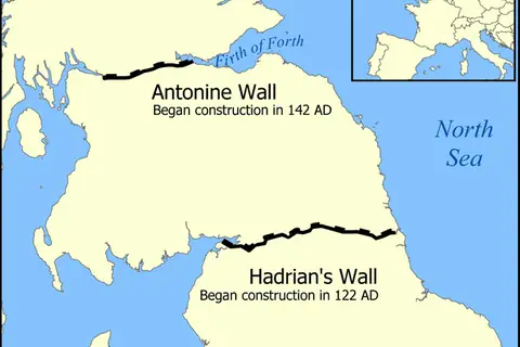
Hadrians Wall Map
Hadrian’s Wall Map – The Epitome of Roman Engineering
Key Takeaways
- Hadrian’s Wall was a monumental Roman frontier fortification in Northern England, built during the reign of Emperor Hadrian.
- The wall was approximately 73 miles long, spanning from the east coast of England (modern-day Newcastle) to the west coast (modern-day Solway Firth).
- It served as a territorial boundary, military defense structure, and customs control point.
- Hadrian’s Wall is a UNESCO World Heritage site, attracting tourists and historians from around the globe.
- The construction of the wall began in AD 122 and took approximately six years to complete.
History
Hadrian’s Wall, also known as Vallum Aelium in Latin, was commissioned by Emperor Hadrian in AD 122. The wall marked the
northernmost boundary of Roman Britain during that time. Its construction was a testament to Roman engineering prowess,
as it included elaborate fortifications, milecastles, barracks, and defensive structures.
The purpose of Hadrian’s Wall was to establish control over the northern territories and serve as a visible statement
of Roman power and might. It played a crucial role in defending Roman Britain from invasions by Pictish tribes from
the north. Additionally, it enforced customs controls, allowing the Romans to regulate trade and collect taxes.
The wall served as a symbol of oppression for some while offering a sense of security for others. Despite the
strategic significance of Hadrian’s Wall, the Romans withdrew from Britain in the early 5th century, leaving the wall
to decay over time. However, its ruins still stand as a testament to the power and influence of the Roman Empire.
Unique Insights
- Roman Milecastles: Hadrian’s Wall was punctuated by 16 Roman milecastles, which served as small forts and observation posts.
- Birdoswald Roman Fort: One of the best-preserved forts along the wall, Birdoswald provides visitors with insight into Roman military life.
- World Heritage Site: Hadrian’s Wall was designated a UNESCO World Heritage site in 1987, recognizing its cultural significance.
- The Vallum: The Vallum refers to a large ditch constructed on the southern side of the wall, acting as an additional defense feature.
- Archaeological Discoveries: Excavations along the wall have uncovered various artifacts, shedding light on life in Roman Britain.
Table of Relevant Facts
| Year | Event |
|---|---|
| AD 122 | Construction of Hadrian’s Wall begins under Emperor Hadrian’s orders. |
| AD 128 | Wall construction is completed, including forts, milecastles, and connecting roads. |
| AD 197 | The northern frontier of Roman Britain is moved to the Antonine Wall in Scotland. |
| AD 410 | The Roman Empire withdraws from Britain, leading to the decline of Hadrian’s Wall. |
Frequently Asked Questions (FAQ)
1. How long is Hadrian’s Wall?
Hadrian’s Wall stretches approximately 73 miles across Northern England.
2. When was Hadrian’s Wall built?
The construction of Hadrian’s Wall began in AD 122 and was completed around AD 128.
3. What was the purpose of Hadrian’s Wall?
Hadrian’s Wall served as a territorial boundary, military defense structure, and customs control point.
4. Can I visit Hadrian’s Wall today?
Yes, Hadrian’s Wall is a popular tourist attraction and open for visitors to explore its ruins and learn about Roman history.
5. Are there any well-preserved forts along Hadrian’s Wall?
Yes, Birdoswald Roman Fort is one of the best-preserved forts along Hadrian’s Wall.
6. How long did it take to build Hadrian’s Wall?
The construction of Hadrian’s Wall took approximately six years to complete.
7. Is Hadrian’s Wall a UNESCO World Heritage site?
Yes, Hadrian’s Wall was designated as a UNESCO World Heritage site in 1987.
External Links
- English Heritage – Hadrian’s Wall
- sites/hadrians-wall-world-heritage-site/”>UNESCO UK – Hadrian’s Wall
- National Geographic – Hadrian’s Wall
LSI Keywords
- Hadrian’s Wall history
- Roman engineering
- Hadrian’s Wall facts
- Hadrian’s Wall construction
- Milecastles along Hadrian’s Wall
- UNESCO World Heritage site
- Roman forts in England