Kashmir Map
Kashmir Map: A Comprehensive Guide
Key Takeaways
- The Kashmir map represents the stunning geography of the region, known for its natural beauty.
- Cartographers meticulously depict the topography, rivers, lakes, and mountain ranges on the map.
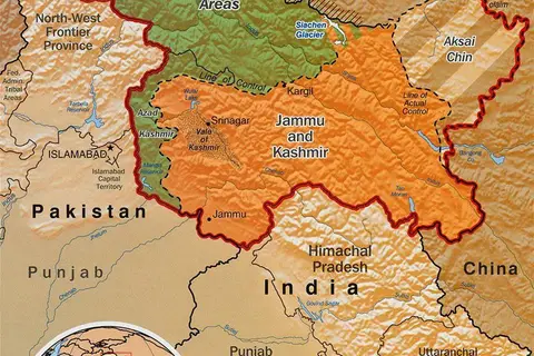
- The map showcases the disputed territories between India, Pakistan, and China.
- Kashmir has historical, cultural, and political significance, making its map highly sought after.
History of Kashmir
The region of Kashmir, situated in the northern part of the Indian subcontinent, has a rich history dating back thousands of years. The Kashmir Valley, renowned for its breathtaking landscapes, has attracted numerous civilizations due to its natural resources and strategic location along ancient trade routes.
Over the centuries, various dynasties, including the Mauryans, Kushans, and Guptas, ruled over Kashmir. During medieval times, Islam spread to the region, influencing its culture and traditions. In the 19th century, the British incorporated Kashmir into their colonization efforts in the Indian subcontinent.
Post-independence, Kashmir became a disputed territory claimed by India and Pakistan, leading to ongoing conflicts and geopolitical tensions. The region is currently divided between the two nations, along with a smaller portion controlled by China.
Unique Insights
Natural Beauty and Landmarks
Kashmir is often referred to as “Paradise on Earth” due to its enchanting natural beauty. The Kashmir map showcases the iconic Dal Lake, situated in the heart of Srinagar, and surrounded by majestic mountains. This lake, with its intricate network of houseboats and floating gardens, captivates visitors with its serene charm.
The map also highlights other famous landmarks, including the Nigeen Lake, Pahalgam – a popular tourist destination, and Gulmarg – renowned for its picturesque meadows and skiing opportunities.
Political Significance and Disputed Territories
The Kashmir map plays a crucial role in understanding the political dynamics of the region. It illustrates the contested territories of Jammu and Kashmir, with areas controlled by India, Pakistan, and China. The Indian-administered region is further divided into three divisions: Jammu, Kashmir Valley, and Ladakh.
The ongoing territorial disputes have had significant geopolitical implications and are a source of tension between India and Pakistan. Despite attempts for resolution, the issue remains unresolved as both nations claim sovereignty over the entire region.
Relevant Facts
| Year | Event |
|---|---|
| 1947 | India and Pakistan gained independence, leading to the division of Kashmir. |
| 1962 | India and China fought a war, resulting in China gaining control over Aksai Chin. |
| 1989 | An armed insurgency against Indian rule began in the Kashmir Valley. |
| 1999 | India and Pakistan engaged in the Kargil conflict, centered around the Kashmir region. |
Frequently Asked Questions
1. Why is the Kashmir map significant?
The Kashmir map is significant due to the region’s historical, cultural, and political importance. It helps understand the disputed territories and ongoing conflicts between nations.
2. What are the major landmarks in Kashmir?
Some major landmarks in Kashmir include Dal Lake, Nigeen Lake, Pahalgam, and Gulmarg.
3. Who controls the Kashmir region?
The Kashmir region is divided between India, Pakistan, and China. India controls the largest portion, followed by Pakistan and a smaller Chinese-administered area.
4. What is the significance of Dal Lake?
Dal Lake is a prominent feature on the Kashmir map and is known for its beauty and the unique experience of staying on traditional houseboats floating on the lake.
5. Why is there a dispute over Kashmir?
The dispute over Kashmir stems from conflicting claims by both India and Pakistan, dating back to the partition of India in 1947. Both countries assert sovereignty over the entire region.
6. Are there any ongoing conflicts in Kashmir?
Kashmir continues to experience conflicts and political tensions due to the unresolved territorial disputes between India, Pakistan, and China.
7. Can tourists visit Kashmir?
Yes, despite the political complexities, Kashmir remains a popular tourist destination. However, travelers are advised to stay informed about the current situation and follow travel advisories.