Kerala Express and Swarnajayanthi Express Trivandrum New Delhi Route Map
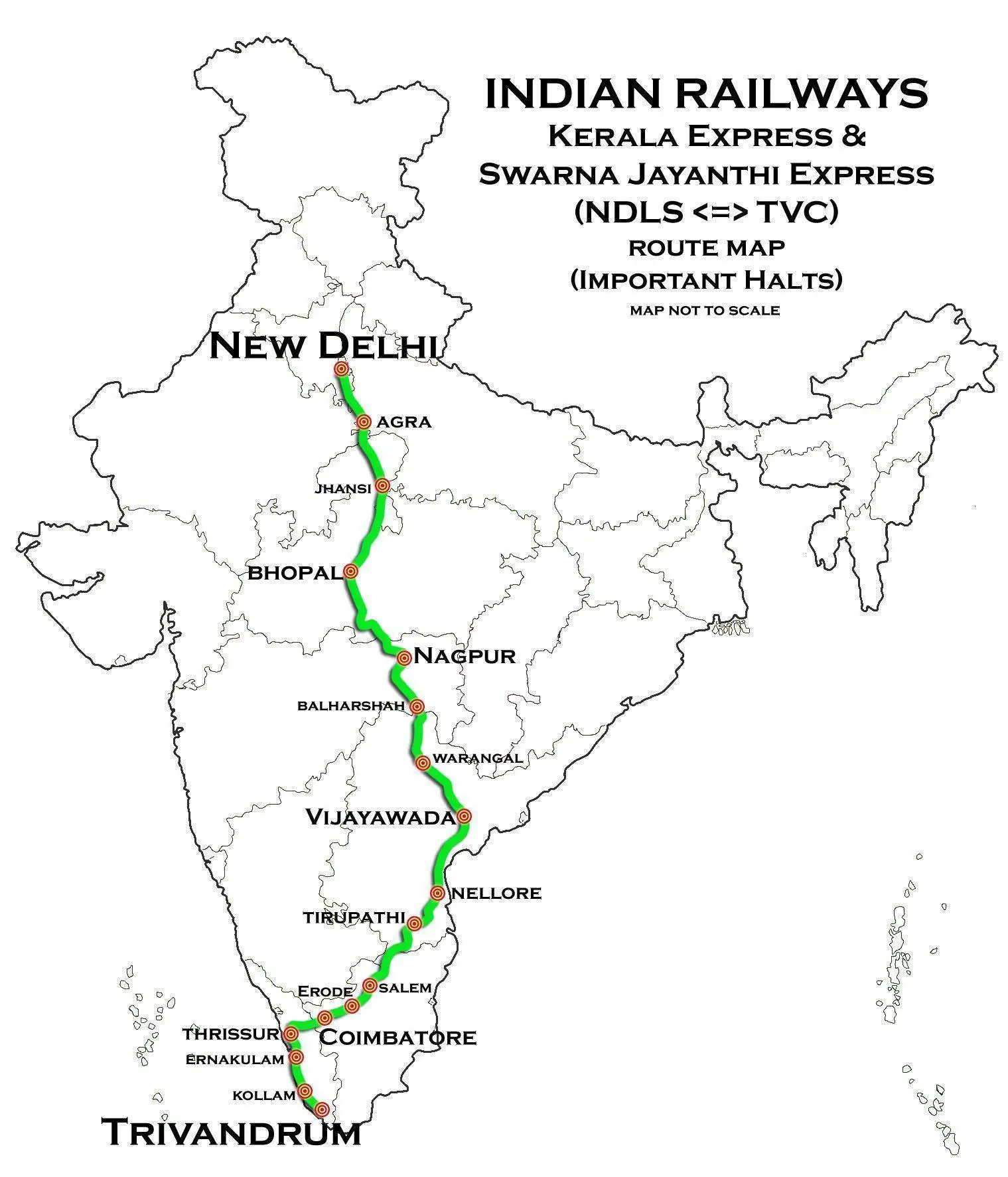
Click or tap the map to enlarge it.
Key Takeaways
- The Kerala Express and Swarnajayanthi Express are important train services connecting Trivandrum and New Delhi.
- The route map showcases the major stations and important landmarks along the way.
- The journey covers diverse landscapes and offers a glimpse into India’s rich cultural heritage.
History
The Kerala Express and Swarnajayanthi Express are two prominent train services that connect Trivandrum, the capital
city of Kerala, with New Delhi, the capital city of India. The route map of these trains provides a visual
representation of the extensive journey. Let’s explore the highlights of this captivating route.
Unique Insights
The route between Trivandrum and New Delhi covers a distance of approximately 3,070 kilometers and takes around
50 hours to complete. Throughout the journey, passengers witness the breathtaking landscapes, architectural
marvels, and cultural diversity of India. Here are some unique insights about the route:
- The Kerala Express passes through major cities such as Coimbatore, Erode, Chennai, and Vijayawada before
reaching New Delhi. Each of these cities has its own historical, cultural, and economic significance. - As you travel north, the terrain changes gradually. Starting from the coastal plains of Trivandrum, the
route takes you through the Deccan Plateau, crossing vast stretches of fertile lands and fields. - One of the highlights of the journey is crossing the Krishna River near Vijayawada. The river holds immense
religious and historical significance in the region. - As the train approaches the northern states, the landscape becomes more arid, showcasing the contrast in
geographical features throughout the country. - Passengers can catch glimpses of iconic monuments like the Charminar in Hyderabad and the Red Fort in Delhi
during the journey.
Route Map and Key Stations
| Station | Key Landmarks |
|---|---|
| Trivandrum Central | Napier Museum, Thiruvananthapuram Zoo |
| Kollam Junction | Ashramam Picnic Village, Thangassery Lighthouse |
| Ernakulam Junction | Mattancherry Palace, Fort Kochi |
| Coimbatore Junction | Marudamalai Temple, VOC Park and Zoo |
| Erode Junction | Sathyamangalam Wildlife Sanctuary, Vellode Birds Sanctuary |
| Chennai Central | Marina Beach, Kapaleeshwarar Temple |
| Vijayawada Junction | Kanaka Durga Temple, Prakasam Barrage |
| New Delhi | Red Fort, Qutub Minar |
Frequently Asked Questions (FAQs)
-
How long does the journey between Trivandrum and New Delhi take?
The journey takes approximately 50 hours to complete.
-
Which are the major cities covered during the journey?
The major cities covered include Coimbatore, Erode, Chennai, and Vijayawada.
-
What are the key landmarks at Trivandrum Central?
The key landmarks at Trivandrum Central are the Napier Museum and Thiruvananthapuram Zoo.
-
Are there any historical monuments along the route?
Yes, passengers can catch glimpses of historical monuments like the Charminar in Hyderabad and the Red Fort
in Delhi. -
Is there any wildlife sanctuary near Erode Junction?
Yes, the Sathyamangalam Wildlife Sanctuary is near Erode Junction.
-
Which river is crossed near Vijayawada?
The journey includes crossing the Krishna River near Vijayawada.
-
What is the approximate distance between Trivandrum and New Delhi?
The distance between Trivandrum and New Delhi is approximately 3,070 kilometers.