Map Indicating Baffin Island Nunavut Canada
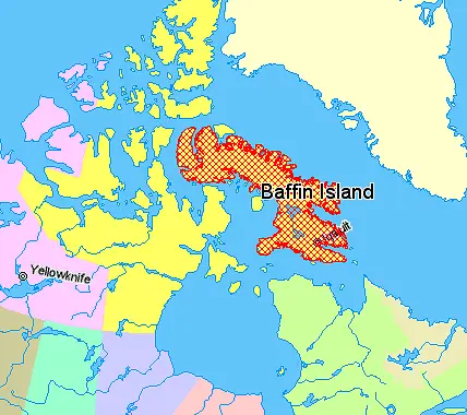
Click or tap the map to enlarge it.
Map Indicating Baffin Island Nunavut Canada
Key Takeaways:
- Baffin Island is the largest island in Canada and the fifth-largest island in the world.
- Located in the territory of Nunavut, Baffin Island offers stunning natural landscapes.
- The map highlights the geographical location of Baffin Island within Nunavut, Canada.
- Exploring Baffin Island provides opportunities for outdoor activities and wildlife encounters.
History
Baffin Island has a rich history that dates back thousands of years. Indigenous peoples, including the Inuit, have inhabited the island for centuries, maintaining a deep connection with the land and its resources. European exploration of Baffin Island began in the 16th century, with visits from explorers like Martin Frobisher and Robert Bylot. The island was named after English navigator William Baffin, who extensively explored the region in the early 17th century.
In the 20th century, Baffin Island became an important area for exploration due to its vast mineral resources. Mining operations began on the island, attracting both Indigenous and non-Indigenous settlers. In 1999, Baffin Island became part of the newly established territory of Nunavut, granting the Inuit greater self-governance and control over their traditional lands.
Unique Insights
Baffin Island’s unique geographic features make it a fascinating destination for adventurers and nature enthusiasts. The island is home to numerous fjords, mountains, and glaciers, offering breathtaking scenery. A notable feature of Baffin Island is Auyuittuq National Park, which showcases stunning landscapes, including the iconic Mount Thor, known for having the world’s greatest vertical drop.
The island’s remote location and untouched wilderness create excellent opportunities for outdoor activities such as hiking, wildlife observation, and kayaking. Visitors can spot a diverse range of wildlife, including polar bears, Arctic foxes, caribou, and various bird species. Baffin Island is also known for its vibrant Inuit culture, providing visitors with a chance to learn about traditional practices, art, and history.
Table of Relevant Facts
| Year | Event |
|---|---|
| 1500s | Baffin Island explored by European explorers, including Martin Frobisher. |
| 1616 | William Baffin explores and names the island. |
| 20th century | Baffin Island becomes a significant area for mining operations. |
| 1999 | Baffin Island becomes part of the newly established territory of Nunavut. |
FAQ
-
What is the size of Baffin Island?
Baffin Island is the largest island in Canada, with an area of approximately 507,451 square kilometers.
-
Where is Baffin Island located?
Baffin Island is located in the territory of Nunavut, Canada, in the northeastern part of the country.
-
What is the significance of Auyuittuq National Park?
Auyuittuq National Park showcases the stunning landscapes of Baffin Island, including Mount Thor, known for its vertical drop.
-
What outdoor activities can be done on Baffin Island?
Baffin Island offers a range of outdoor activities, including hiking, wildlife observation, and kayaking.
-
What wildlife can be found on Baffin Island?
Visitors to Baffin Island may encounter polar bears, Arctic foxes, caribou, and various bird species.
-
How does Baffin Island connect to Inuit culture?
Baffin Island is home to vibrant Inuit communities, providing visitors with an opportunity to learn about traditional practices, art, and history.
-
Is Baffin Island easily accessible for tourists?
Baffin Island’s remote location requires careful planning and arrangements to access the island. It is recommended to consult with local travel agencies for guidance.