Map Indonesia Volcanoesru
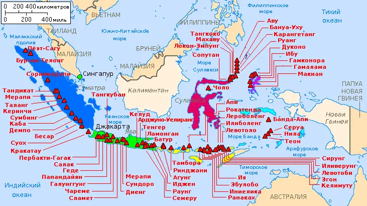
Click or tap the map to enlarge it.
Key Takeaways
- Explore the diverse volcanic landscapes of Indonesia with the Map Indonesia Volcanoesru.
- Discover detailed information on over 100 active and dormant volcanoes across the Indonesian archipelago.
- Learn about historical eruptions, unique geological features, and the significance of volcanoes in Indonesian culture.
- Plan your adventures and research volcanic activity with the help of this comprehensive map.
History
The history of volcanic activity in Indonesia is as captivating as it is tumultuous. With its location along the Pacific Ring of Fire, Indonesia is home to a staggering 127 active volcanoes, more than any other country in the world. The archipelago’s rich volcanic soil has blessed the nation with fertile lands, but it also poses challenges and dangers.
Volcanic eruptions have been documented throughout Indonesia’s history, some with catastrophic consequences. The 1815 eruption of Mount Tambora, located on the island of Sumbawa, is considered one of the most powerful eruptions in recorded history. This massive event had a profound impact on global climate, leading to the infamous ‘Year Without a Summer’ in 1816.
Despite the risks, the volcanic landscapes of Indonesia continue to attract adventurers, scientists, and geology enthusiasts from around the world. Each volcano has its unique characteristics, offering different experiences and insights into the Earth’s geological wonders.
Unique Insights
The Map Indonesia Volcanoesru provides a wealth of unique insights into Indonesia’s volcanic world. Here are some noteworthy points:
- Indonesia’s volcanoes are categorized into four types: stratovolcanoes, caldera volcanoes, shield volcanoes, and volcanic complexes.
- Mount Bromo, located in East Java, is one of the most iconic and easily accessible volcanoes in Indonesia, offering visitors mesmerizing views of its smoking crater.
- Anak Krakatau, also known as “Child of Krakatoa,” rose from the sea after the cataclysmic eruption of Krakatoa in 1883. It serves as a reminder of the immense power of volcanic activity.
- The Toba Caldera, located in Sumatra, is not only the largest volcanic lake in the world but also the site of one of Earth’s most catastrophic volcanic super-eruptions around 75,000 years ago.
- Indonesian culture is intricately intertwined with volcanoes. Many locals regard them as sacred entities and believe in spiritual connections between volcanoes and deities.
Table of Relevant Facts
| Volcano Name | Location | Last Eruption | Height |
|---|---|---|---|
| Mt. Krakatoa | Sunda Strait, between Java and Sumatra | 1883 | 813 meters |
| Mt. Merapi | Central Java | 2020 | 2,930 meters |
| Mt. Rinjani | Lombok Island | 2016 | 3,726 meters |
FAQ
1. How many active volcanoes are there in Indonesia?
Indonesia is home to 127 active volcanoes, the highest number in the world.
2. Which volcano in Indonesia had the most powerful eruption?
The 1815 eruption of Mount Tambora is considered one of the most powerful eruptions in recorded history.
3. Are all Indonesian volcanoes accessible to the public?
While some volcanoes have restricted access due to safety concerns, many, like Mount Bromo, can be visited by tourists.
4. Do volcanic eruptions in Indonesia have any impact on global climate?
Yes, large volcanic eruptions can release significant amounts of ash and gases into the atmosphere, which can affect global temperatures.
5. Is it safe to live near Indonesian volcanoes?
Living near active volcanoes comes with risks, but authorities closely monitor volcanic activity and take necessary precautions to ensure public safety.
6. Are there any volcanic lakes in Indonesia?
Yes, the Toba Caldera in Sumatra is the largest volcanic lake in the world, created by a catastrophic super-eruption thousands of years ago.
7. What cultural significance do volcanoes hold in Indonesian society?
Volcanoes are often considered sacred, and many communities hold rituals and traditions that honor their spiritual connections with these powerful natural phenomena.