Map of Central America
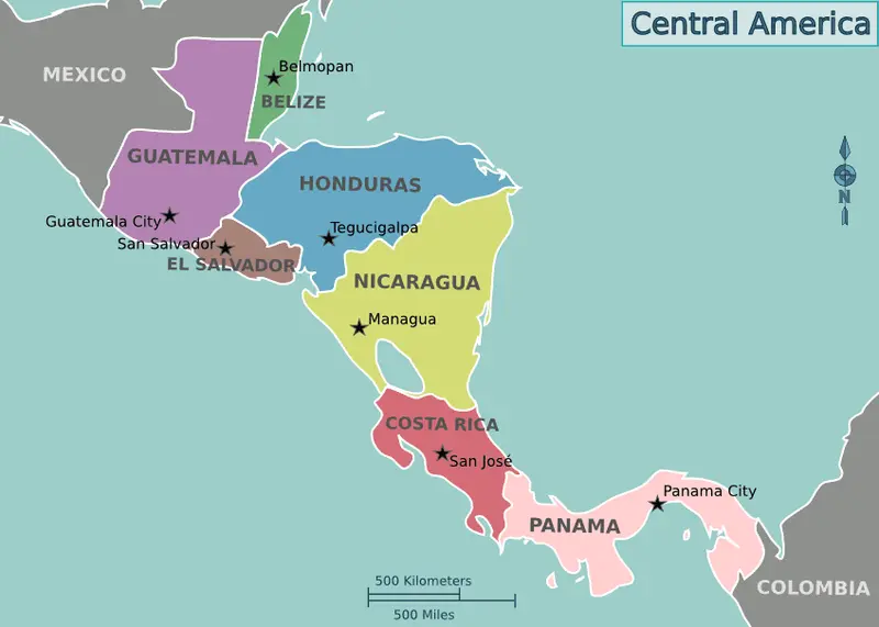
Click or tap the map to enlarge it.
Map of Central America – A Comprehensive Guide
Key Takeaways:
- Central America is a region located between North and South America.
- It consists of seven countries: Belize, Costa Rica, El Salvador, Guatemala, Honduras, Nicaragua, and Panama.
- The map of Central America provides valuable geographical information about the area and its features.
- It is an important tool for travelers, geographers, and researchers.
History of Central America:
Central America holds a rich and diverse history that dates back thousands of years. The area was originally inhabited by various indigenous civilizations, including the Maya, Aztec, and Olmec. These ancient civilizations played a crucial role in shaping the cultural and historical significance of Central America.
During the colonial period, the region was dominated by European powers, primarily Spain. Spanish colonization heavily influenced the language, religion, and political systems of Central America.
In the 19th century, several countries in Central America gained their independence from Spain and formed their own nations. However, internal conflicts and political instability have been significant challenges for the region throughout its history.
Unique Insights about the Map of Central America:
- Central America is home to stunning natural landscapes, including tropical rainforests, beautiful beaches, and impressive mountain ranges.
- The region is known for its biodiversity, with a wide variety of plant and animal species that are endemic to Central America.
- The Panama Canal, an engineering marvel, connects the Pacific Ocean to the Atlantic Ocean, facilitating international trade and transportation.
- Central America experiences a range of climate zones, from tropical rainforest to dry tropical and highland climates.
- The map of Central America showcases the location of important cities, landmarks, national parks, and archaeological sites.
Table of Relevant Facts:
| Year | Event |
|---|---|
| 1502 | Christopher Columbus arrives in what is now Central America during his fourth voyage. |
| 1821 | Several Central American countries declare independence from Spain. |
| 1850-1914 | The construction of the Panama Canal takes place, connecting the Atlantic and Pacific Oceans. |
| 1980s-1990s | Central America experiences civil wars and political conflicts. |
| 2006 | Costa Rica becomes the first Central American country to have an elected female president. |
Frequently Asked Questions (FAQ) about the Map of Central America:
-
What countries are included in Central America?
Central America consists of seven countries: Belize, Costa Rica, El Salvador, Guatemala, Honduras, Nicaragua, and Panama.
-
What is the significance of the Panama Canal?
The Panama Canal is a vital waterway that connects the Atlantic Ocean to the Pacific Ocean, facilitating international trade and transportation.
-
What are some popular tourist destinations in Central America?
Central America is known for its stunning natural beauty, and some popular tourist destinations include the ancient Mayan ruins in Guatemala, the beaches of Costa Rica, and the islands of Belize.
-
What is the climate like in Central America?
Central America experiences a diverse range of climates, from tropical rainforests to highland regions with cooler temperatures.
-
What is the official language of Central America?
Spanish is the official language of most Central American countries, although English is spoken in Belize.
-
What are some famous landmarks in Central America?
Some famous landmarks include the ancient city of Tikal in Guatemala, the Panama Canal, and the Arenal Volcano in Costa Rica.
-
How can the map of Central America be useful?
The map of Central America provides valuable information about the geographical features, cities, and landmarks of the region. It can be used by travelers, researchers, and students studying the area.