Map of Participants in World War Ii
Key Takeaways
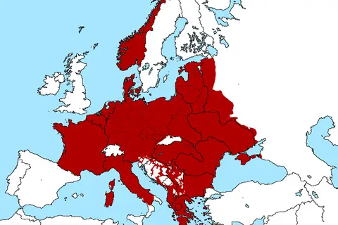
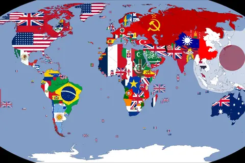
- The map of participants in World War II provides a visual representation of the countries involved during the war.
- Understanding the geographical distribution of nations involved can aid in comprehending the scale and impact of World War II.
- The map illustrates the alliances and axis powers that shaped the conflict, highlighting the global nature of the war.
- Exploring the map can help us gain insights into the strategies, outcomes, and complexities of the war.
History
World War II, spanning from 1939 to 1945, was a global conflict that involved numerous nations across the world. It was fought between two major alliances – the Allies and the Axis powers. The map of participants in World War II serves as a valuable resource to understand the geographical distribution of these participating countries.
The two primary alliances during the war consisted of:
The Allies
The Allies, or Allied powers, were the nations that opposed the Axis powers. Some of the major Allied powers were:
- United States
- United Kingdom
- Soviet Union
- China
- France
The Axis Powers
The Axis powers consisted of countries that formed an alliance to promote their political and military interests. Some of the major Axis powers were:
- Germany
- Italy
- Japan
The map of participants in World War II offers a visual representation of the geographical locations where these nations were situated during the conflict.
Table of Relevant Facts
| Alliance | Countries | Years Active |
|---|---|---|
| Allies | United States, United Kingdom, Soviet Union, China, France, and more | 1939-1945 |
| Axis Powers | Germany, Italy, Japan, and more | 1939-1945 |
Unique Insights
- World War II was an extensively global conflict, involving countries from various continents.
- The alliances formed by different nations played a significant role in determining the outcomes of battles and the overall course of the war.
- The geopolitical divisions during World War II were complex, reflecting the political landscape of that era.
- The map showcases the proximity of nations involved in the war, highlighting the challenges and complexities faced by both sides.
- Examining the map can provide insights into the spread and impact of the war on different regions.
Frequently Asked Questions (FAQ)
-
Which countries were part of the Allies during World War II?
The Allies included countries such as the United States, United Kingdom, Soviet Union, China, France, and many others.
-
What were the Axis powers during World War II?
The Axis powers were primarily composed of Germany, Italy, Japan, and a few other nations.
-
How long did World War II last?
World War II lasted from 1939 to 1945.
-
What role did geographical location play in World War II?
Geographical location played a crucial role in World War II as it determined the strategic positions of different nations and influenced military strategies.
-
Did World War II involve countries from every continent?
Yes, World War II involved countries from Europe, Asia, North America, Oceania, and Africa, making it a truly global conflict.
-
How does the map of participants in World War II help us understand the war?
The map provides a clear visual representation of the participating nations, their alliances, and their geographical distribution during the war. It aids in comprehending the scale, scope, and impact of World War II.
-
What were the outcomes of World War II?
World War II led to significant geopolitical changes, the establishment of new international organizations such as the United Nations, the division of Germany, and the rise of the United States and the Soviet Union as global superpowers.