Map of Rohingya People in Rakhine State
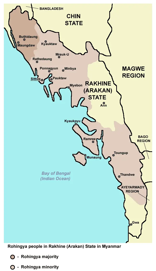
Click or tap the map to enlarge it.
Map Of Rohingya People In Rakhine State
Key Takeaways
- The Map of Rohingya People in Rakhine State highlights the geographic location of this region.
- Rakhine State is a significant area in Myanmar due to its diverse culture and historical significance.
- This map showcases the distribution and concentration of the Rohingya people, an ethnic minority in Rakhine State.
- Understanding this map is crucial to comprehend the socio-political landscape and ongoing conflicts in the region.
History of Rakhine State
Rakhine State, located in western Myanmar, has a rich and complex history. It has been influenced by various civilizations, including the Dhanyawadi, Vesali, and Mrauk U Kingdoms. These kingdoms played a vital role in the regional trade network and brought prosperity to the area.
The arrival of Europeans, particularly the British, in the 19th century had a significant impact on Rakhine State. They established an administration and introduced modern infrastructure, leading to further development.
However, the region also faced socio-political challenges. During World War II, Rakhine State witnessed conflicts between the Japanese, British, and local insurgent groups. The aftermath of the war brought increased tensions and eventually led to communal violence between different ethnic and religious groups.
Unique Insights
The Map of Rohingya People in Rakhine State provides several unique insights into the region:
- The concentration of Rohingya people is primarily found in northern Rakhine State, close to the border with Bangladesh.
- Rakhine State is home to diverse ethnic communities, including the Rakhine Buddhists, Rohingya Muslims, and other minority groups.
- The complex interplay of historical, cultural, and political factors has contributed to the ongoing conflicts and humanitarian concerns in the region.
Table of Relevant Facts
| Year | Event |
|---|---|
| 1942 | Communal violence between Rohingya Muslims and Rakhine Buddhists. |
| 1982 | The Citizenship Law of Myanmar excludes Rohingya people, rendering them stateless. |
| 2012 | Renewed violence between Rohingya Muslims and Rakhine Buddhists left hundreds dead and thousands displaced. |
| 2017 | Rohingya refugee crisis intensified as military crackdown led to mass displacement. |
Frequently Asked Questions (FAQ)
-
What is the significance of Rakhine State?
Rakhine State is significant due to its cultural diversity, historical heritage, and ongoing conflicts that draw international attention.
-
Why are the Rohingya people stateless?
The Citizenship Law of Myanmar passed in 1982 excluded the Rohingya people, rendering them stateless in their own homeland.
-
Where is the concentration of Rohingya people on the map?
The concentration of Rohingya people is predominantly found in northern Rakhine State, near the border with Bangladesh.
-
What historical events have affected Rakhine State?
Rakhine State has been impacted by various historical events, including World War II and ongoing communal conflicts.
-
What are the ongoing conflicts in Rakhine State?
The ongoing conflicts in Rakhine State involve political, ethnic, and religious tensions, resulting in human rights violations.
-
What is the Rohingya refugee crisis?
The Rohingya refugee crisis refers to the mass displacement of Rohingya people due to military crackdown and persecution in Myanmar.
-
How does the map help understand the situation in Rakhine State?
The map showcases the concentration of Rohingya people and their distribution, providing insight into the socio-political landscape and ongoing conflicts in the region.