Map of the 78 Municipalities of Puerto Rico
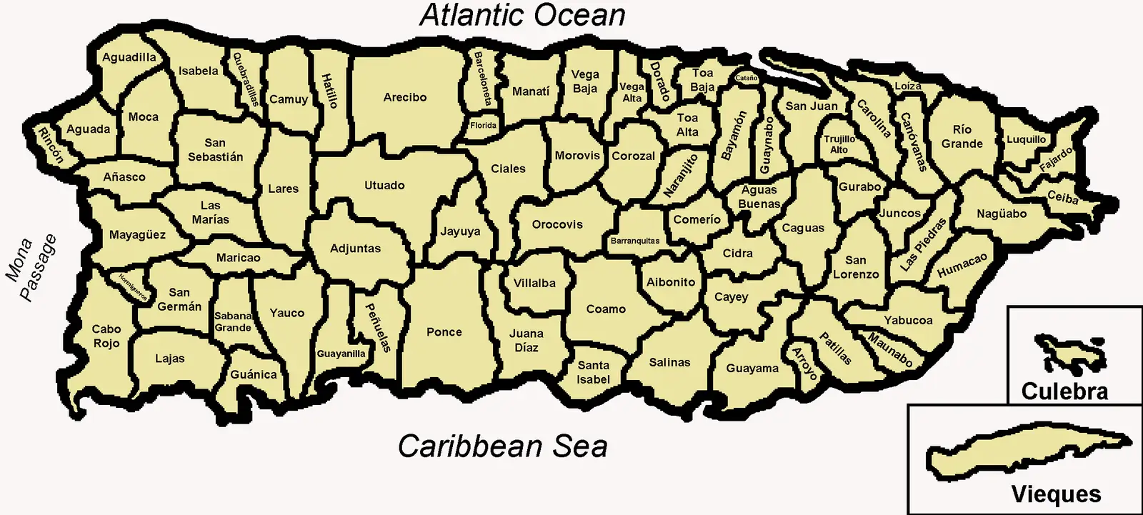
Click or tap the map to enlarge it.
Key Takeaways
- Puerto Rico is divided into 78 municipalities, each with its own unique characteristics.
- The map of the 78 municipalities of Puerto Rico is a valuable resource for understanding the island’s geography and political divisions.
- Exploring the municipalities of Puerto Rico allows for a deeper appreciation of the diversity present within the territory.
History
Puerto Rico, an unincorporated territory of the United States, consists of 78 municipalities. These municipalities have a rich history that dates back centuries. Puerto Rico was originally inhabited by the indigenous Taíno people before being colonized by the Spanish in the 15th century.
Over the years, Puerto Rico saw various changes in its political status and governance. With the arrival of the United States in 1898, Puerto Rico became a U.S. territory, and in 1952, it adopted a commonwealth status. The municipalities of Puerto Rico serve as administrative divisions within the territory and are responsible for local governance.
Unique Insights
Exploring the map of the 78 municipalities of Puerto Rico offers unique insights into the island’s geography, culture, and history. Here are some notable features and insights:
- Ponce, known as the “Pearl of the South,” offers a vibrant art scene and historic architecture.
- Old San Juan, the capital municipality, is a UNESCO World Heritage Site with its colonial architecture and cobblestone streets.
- The municipality of Caguas is well-known for its cultural festivals and musical heritage.
- Arecibo is home to the world’s largest single-dish radio telescope, known as the Arecibo Observatory.
- The El Yunque National Forest, located in the municipality of Río Grande, is the only tropical rainforest in the U.S. National Forest System.
Table of Relevant Facts
| Municipality | Date Established | Population (2019) |
|---|---|---|
| San Juan | 1509 | 319,548 |
| Ponce | 1692 | 166,327 |
| Caguas | 1775 | 142,893 |
| Arecibo | 1616 | 95,502 |
| Río Grande | 1840 | 50,423 |
FAQ
1. How many municipalities does Puerto Rico have?
Puerto Rico consists of 78 municipalities in total.
2. Which is the capital municipality of Puerto Rico?
The capital municipality of Puerto Rico is San Juan.
3. What is the population of Ponce?
As of 2019, the population of Ponce is approximately 166,327.
4. Which municipality is known as the “Pearl of the South”?
Ponce is often referred to as the “Pearl of the South” due to its vibrant art scene and historic architecture.
5. What is the significance of Arecibo?
Arecibo is home to the world’s largest single-dish radio telescope, known as the Arecibo Observatory.
6. Which municipality is home to the El Yunque National Forest?
The El Yunque National Forest is located in the municipality of Río Grande.
7. When did Caguas become a municipality?
Caguas became a municipality in 1775.