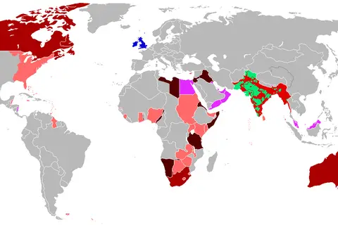
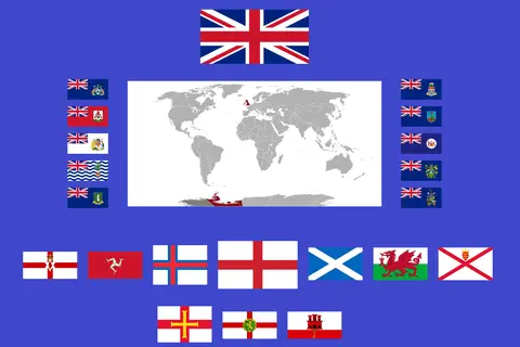
Map of the British Empire in the 1920S
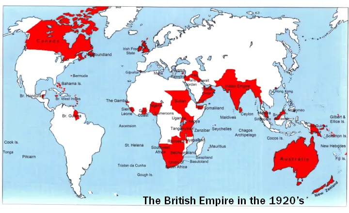
Click or tap the map to enlarge it.
Key Takeaways
- The Map of the British Empire in the 1920s depicts the vast territories that were under the control of the British Empire during that time.
- This map showcases the global reach and influence of the British Empire, which was once the largest empire in history.
- The British Empire in the 1920s covered a significant portion of the world, including territories in Europe, Africa, Asia, the Americas, and the Pacific.
- Exploring this map offers valuable insights into the colonial legacy and the extent of British imperialism during the early 20th century.
History
The British Empire reached its territorial zenith in the early 1920s. At its height, the empire contained over 23% of the world’s population, holding sway over an estimated 458 million people. It spanned approximately 35 million square kilometers, making it the largest empire in history.
The British Empire was characterized by its vast colonial holdings, which spread across five continents. The map of the British Empire in the 1920s demonstrates the extensive territories under British control, including Canada, Australia, India, Egypt, South Africa, parts of the Caribbean, and numerous other colonies and protectorates.
Unique Insights
- The British Empire in the 1920s was a diverse collection of territories, each with its own unique social, cultural, and economic characteristics.
- Colonial rule varied across different regions, from direct rule in some locations to indirect rule in others.
- The empire was sustained through global trade networks that facilitated the exportation of goods and resources from the colonies to Britain.
- The overextension of the British Empire, along with rising nationalist movements, would eventually lead to its decline and the granting of independence to many former colonies in the following decades.
Table of Relevant Facts
| Year | Event |
|---|---|
| 1919 | Treaty of Versailles was signed, redrawing European borders and affecting colonial territories |
| 1922 | The Irish Free State gained independence from the United Kingdom |
| 1929 | The Wall Street Crash triggered a global economic downturn, impacting British trade and imperial policies |
FAQ
1. What were the key countries and territories under British control in the 1920s?
During the 1920s, key countries and territories under British control included India, Canada, Australia, New Zealand, Egypt, Sudan, Kenya, South Africa, Nigeria, and numerous Caribbean islands, among others.
2. How did the British Empire maintain control over such vast territories?
The British Empire maintained control through a combination of military force, political alliances with local elites, and the establishment of administrative systems that facilitated colonial governance.
3. What were the economic benefits of the British Empire in the 1920s?
The British Empire benefited economically by exploiting the natural resources and labor of its colonies, allowing for the growth of industries and the accumulation of wealth in Britain.
4. What led to the decline and eventual dismantling of the British Empire?
The decline of the British Empire was primarily driven by rising nationalist movements in colonized territories, global changes in the balance of power after World War II, and increasing pressure for decolonization and self-determination.
5. Did the British Empire have any positive impacts on its colonies?
The British Empire introduced modern forms of governance, infrastructure, and education systems that, to some extent, had lasting positive impacts. However, these benefits were often outweighed by the negative consequences of exploitation and cultural domination.
6. How did the map of the British Empire change in the following decades?
In the following decades, the British Empire gradually lost control over its colonies, granting them independence or ceding them to other powers. By the mid-20th century, most of the empire had dissolved.
7. Is the legacy of the British Empire still visible today?
Yes, the legacy of the British Empire is still visible in many former colonies, including their legal systems, languages, educational institutions, and social structures. However, it is also a subject of ongoing debates and controversies.