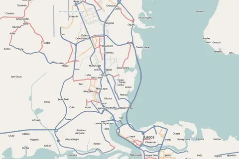
Map of the Local Government Areas of Lagos
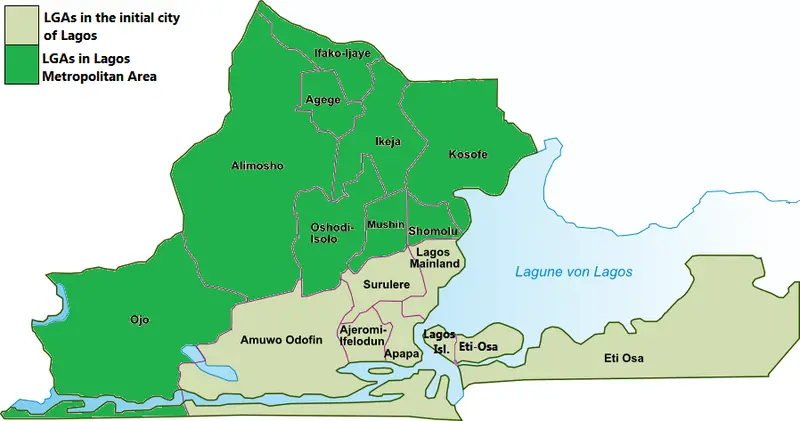
Click or tap the map to enlarge it.
Key Takeaways
- The “Map of the Local Government Areas of Lagos” showcases the administrative divisions in Lagos, Nigeria.
- This map provides important geographical information, highlighting the boundaries and locations of the local government areas.
- Understanding the local government areas can aid in navigation, planning, and resource allocation within Lagos.
History
The Local Government Areas (LGAs) of Lagos, Nigeria, have evolved over time to meet the changing administrative needs of the region. Lagos State, founded on May 27, 1967, originally comprised of five administrative divisions known as “divisions” or “districts.” These divisions were Lagos, Ikeja, Badagry, Ikorodu, and Epe.
As Lagos continued to grow in population and importance, the need for more localized governance led to the establishment of additional LGAs. Currently, Lagos State consists of 20 LGAs, each with its own elected local government council.
Unique Insights
Exploring the map of the Local Government Areas of Lagos reveals several unique insights about the region:
- Lagos Island is the central business district of Lagos and houses important landmarks such as the Central Mosque, Tafawa Balewa Square, and the popular Idumota Market.
- Surulere LGA is known for its vibrant entertainment scene and hosts the National Stadium, which has hosted several national and international sporting events.
- Mainland LGAs, including Ikeja and Agege, serve as major residential and commercial hubs, with diverse markets and shopping centers.
- Eti-Osa LGA is home to prominent tourist attractions such as the Lekki Conservation Centre, Nike Art Gallery, and the popular beaches of the Lekki Peninsula.
- Several LGAs, including Alimosho, Mushin, and Kosofe, have experienced significant population growth, leading to increased infrastructural development.
Table of Relevant Facts
| Year | Event |
|---|---|
| 1967 | Lagos State created with five administrative divisions. |
| 1976 | Creation of additional LGAs, including Eti-Osa, Ifelodun, and Ikorodu. |
| 1991 | Creation of additional LGAs, including Alimosho, Mushin, and Kosofe. |
| 2003 | Creation of additional LGAs, including Amuwo-Odofin, Ajeromi-Ifelodun, and Ojo. |
| 2016 | Creation of additional LGAs, including Onigbongbo, Ojokoro, and Badagry West. |
Frequently Asked Questions (FAQ)
1. What is the total number of Local Government Areas in Lagos?
Lagos State is divided into a total of 20 Local Government Areas.
2. How can the Local Government Areas of Lagos be beneficial?
Understanding the Local Government Areas of Lagos can aid in effective governance, urban planning, infrastructure development, service allocation, and community engagement.
3. What are some popular landmarks in Lagos Island LGA?
Some popular landmarks in Lagos Island LGA include the Central Mosque, Tafawa Balewa Square, and Idumota Market.
4. What is significant about Surulere LGA?
Surulere LGA is known for its vibrant entertainment scene and is home to the National Stadium, which hosts various sporting events.
5. Are there any prominent tourist attractions in Eti-Osa LGA?
Eti-Osa LGA is home to attractions such as the Lekki Conservation Centre, Nike Art Gallery, and the beautiful beaches of the Lekki Peninsula.
6. Which LGAs have experienced high population growth?
LGAs such as Alimosho, Mushin, and Kosofe have seen significant population growth, leading to increased infrastructural development.
7. Who governs the Local Government Areas in Lagos?
Each Local Government Area in Lagos is governed by an elected local government council.