Map of Vedic India
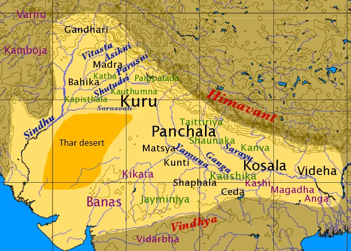
Click or tap the map to enlarge it.
Key Takeaways
- The Map of Vedic India showcases the geographical landscape during the Vedic period.
- This map represents the areas mentioned in ancient Vedic texts and provides insights into the civilization’s expansion and settlements.
- By studying the Map of Vedic India, we gain a deeper understanding of the historical and cultural context of the Vedic period.
History of Vedic India
The Vedic period in ancient India is a significant era renowned for its sacred texts, the Vedas. It extends from approximately 1500 BCE to 500 BCE and marks the emergence of Indo-Aryans in the region. The Vedas, written in Sanskrit, have shaped Indian culture, religious practices, and philosophy for millennia.
The Map of Vedic India provides a visual representation of the areas mentioned in the Vedas, shedding light on the prominent locations and settlements during this era. It is crucial in understanding the geographical scope in which the Vedic civilization thrived.
Unique Insights
Exploring the Map of Vedic India offers unique insights into the expansion, migration, and settlements of the ancient Vedic civilization. Here are some notable observations:
- The Vedic civilization expanded across the Indo-Gangetic plains, including modern-day Northern India, parts of Pakistan, and Bangladesh.
- Key rivers mentioned in the Vedas, such as the Indus (Sindhu) and its tributaries such as the Sarasvati, played significant roles in the development of settlements and trade routes.
- The Vedic people revered nature, giving importance to rivers, mountains, forests, and sacred pilgrimage sites.
- The region was organized into Janapadas (kingdoms) that varied in size, power, and influence.
- Important Vedic cities included Ayodhya, Varanasi (Kashi), Mathura, and Hastinapura, as described in numerous ancient texts.
Table of Relevant Facts
| Time Period | Significant Events |
|---|---|
| 1500 BCE – 1000 BCE | Compilation of the Rigveda, the oldest Vedic text |
| 1200 BCE – 900 BCE | Emergence of Brahmanas, ritualistic texts accompanying the Vedas |
| 900 BCE – 500 BCE | Composition of the Upanishads, philosophical treatises |
FAQs
1. What is the Map of Vedic India?
The Map of Vedic India represents the geographical region mentioned in the ancient texts of the Vedic civilization.
2. What is the significance of the Map of Vedic India?
Studying this map helps us understand the extent of the Vedic civilization’s influence, settlements, and cultural practices during ancient times.
3. Which rivers are mentioned in the Vedas?
The Vedas mention several rivers, including the Indus (Sindhu), Sarasvati, Ganges (Ganga), Yamuna, and more.
4. Were there any important cities during the Vedic period?
Ayodhya, Varanasi (Kashi), Mathura, and Hastinapura are some of the important cities mentioned in Vedic texts.
5. What texts are associated with the Vedic period?
The Vedas, Brahmanas, and Upanishads are the significant texts associated with the Vedic period.
6. What is the time span of the Vedic period?
The Vedic period is believed to have lasted from approximately 1500 BCE to 500 BCE.
7. How did rivers influence the Vedic civilization?
Rivers like the Indus and Sarasvati played vital roles in the development of settlements, trade routes, and the overall culture and lifestyle of the Vedic people.