Mapa Fsico de la Provincia de Alicante Espaa
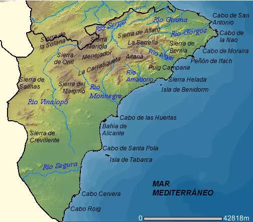
Click or tap the map to enlarge it.
Key Takeaways
- Alicante is a province in Spain with diverse landscapes that can be explored through its physical map.
- The physical map of Alicante showcases its mountain ranges, rivers, coastline, and cities, providing valuable information for various purposes.
- Alicante’s topography influences its climate, agriculture, and tourism, making the map an essential tool for residents and visitors alike.
History
The province of Alicante has a rich history that has shaped its geography over time. The region was inhabited by various civilizations, including the Iberians, Greeks, Carthaginians, and Romans. The Romans had a significant influence on the area and developed its urban infrastructure, including the construction of roads and ports.
During the Middle Ages, Alicante was under Muslim rule for several centuries. The Moors contributed to the agricultural development of the region by introducing new irrigation techniques and cultivating crops such as citrus fruits, almonds, and olives.
In the 13th century, Alicante was reconquered by Christian kingdoms and became part of the Crown of Aragon. The province experienced significant growth during this period, with the establishment of new settlements and the expansion of agriculture and commerce.
Throughout history, Alicante faced various conflicts, including battles during the Spanish Civil War. However, it has persevered and transformed into a vibrant province with a diverse cultural heritage and natural landscapes.
Unique Insights
Exploring the physical map of Alicante provides unique insights into the province’s terrain and geographical features:
- Alicante is characterized by a coastal area stretching across the Mediterranean Sea.
- The province is home to various mountain ranges, including Sierra de Aitana, Sierra de Maigmo, Sierra de Bernia, and Sierra de Crevillente.
- The Vinalopó River and its tributaries, such as the Monnegre River, play a crucial role in the region’s agriculture.
- Alicante has fertile plains and valleys, contributing to its agricultural productivity.
- The province boasts several natural parks and protected areas, preserving its biodiversity and providing opportunities for outdoor activities.
- The physical map also highlights the location of important cities in Alicante, such as Alicante, Elche, and Torrevieja.
Table of Relevant Facts
| Event/Fact | Date |
|---|---|
| Iberian settlement in the region | Circa 6th century BC |
| Roman rule and urban development | 3rd century BC – 5th century AD |
| Islamic rule and agricultural advancements | 8th century – 13th century |
| Christian reconquest and growth | 13th century onwards |
| Battles during the Spanish Civil War | 1936 – 1939 |
FAQ
1. What is the significance of Alicante’s physical map?
Alicante’s physical map is significant as it provides valuable information about the province’s diverse landscapes, including mountains, rivers, coastlines, and cities. It is an essential tool for residents, tourists, and researchers alike.
2. Which are the major mountain ranges in Alicante?
The major mountain ranges in Alicante include Sierra de Aitana, Sierra de Maigmo, Sierra de Bernia, and Sierra de Crevillente.
3. How do the rivers in Alicante contribute to the region?
The rivers, such as Vinalopó and Monnegre, play a vital role in the agriculture of Alicante. They provide irrigation water, helping cultivate a variety of crops and contributing to the region’s productivity.
4. Are there any protected areas in Alicante?
Yes, Alicante is home to several natural parks and protected areas that preserve its biodiversity. These areas offer opportunities for outdoor activities and nature exploration.
5. Which are the major cities in Alicante?
Some of the major cities in Alicante include Alicante, Elche, and Torrevieja.
6. What is the history behind Alicante’s Roman influence?
Alicante was under Roman rule from the 3rd century BC to the 5th century AD. The Romans developed the urban infrastructure, including roads and ports, which significantly influenced the region’s growth and development.
7. How has Alicante transformed over time?
Alicante has transformed from its historical roots as a Roman settlement and through different periods of rulership. Today, it is a vibrant province with a diverse cultural heritage, agricultural significance, and a popular destination for tourism.