Moscow Metro Map Ruslat
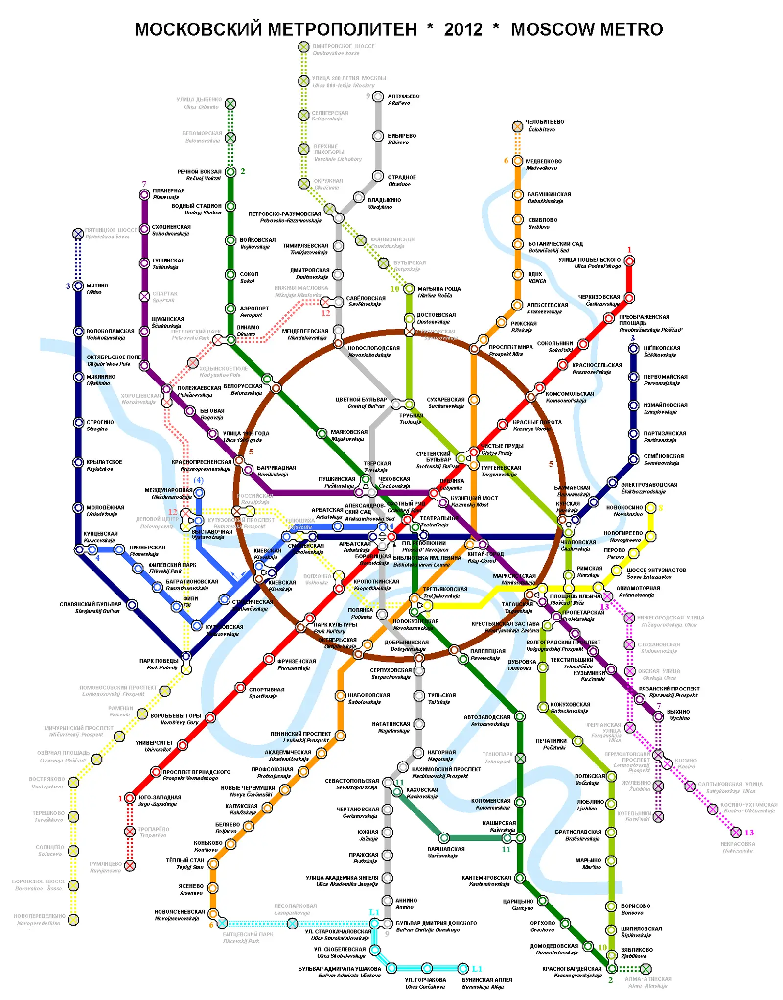
Click or tap the map to enlarge it.
Key Takeaways
- The Moscow Metro is an extensive and efficient metro system that connects the key areas of the city.
- Moscow Metro Map Ruslat is a popular map that provides a clear overview of the metro lines and stations.
- Understanding the history and unique insights of the Moscow Metro enhances the experience of navigating through the city.
History of the Moscow Metro
The Moscow Metro, inaugurated on May 15, 1935, is one of the oldest and most extensive underground railway systems in the world. Designed to showcase Soviet achievements, the metro was a symbol of the country’s progress and technological development. It was initially named the “People’s Commissariat for Transportation Construction of the USSR” and provided a reliable transport network to the growing population of Moscow.
During World War II, the Moscow Metro played a crucial role as bomb shelters and provided safe transportation for citizens. The metro system expanded rapidly over the years, with new lines and stations being constructed to serve the increasing demand. Since its inception, the Moscow Metro has remained an iconic part of the city’s transportation infrastructure and a witness to its rich history.
Unique Insights about the Moscow Metro
The Moscow Metro is not just an efficient mode of transportation; it also offers various unique insights that make it a fascinating attraction for both locals and tourists:
1. Architectural Splendor
The Moscow Metro is renowned for its stunning architecture, featuring grandiose stations that resemble underground palaces. Some stations, such as Komsomolskaya and Mayakovskaya, are adorned with marble columns, chandeliers, intricate mosaics, and beautiful artwork, which reflect the Soviet era’s grandeur. Exploring the metro stations becomes an architectural journey in itself.
2. Soviet Era Art and Propaganda
The artworks found within the Moscow Metro reflect the artistic style and ideology prevalent during the Soviet era. The mosaics, sculptures, and bronze statues depict scenes of daily life, historical events, and the achievements of the Soviet Union. These artistic elements offer a glimpse into a specific period of Russian history and provide a unique cultural experience.
3. Deep Underground Stations and Cold War Secrets
Some stations of the Moscow Metro are built incredibly deep underground due to geological conditions. These deep stations were designed to serve as bomb shelters during the Cold War era and were equipped with facilities to sustain thousands of people for an extended period. While exploration access to these shelter areas is restricted, their hidden existence adds an air of mystery to the underground network.
Table of Relevant Facts for the Moscow Metro
| Year | Key Event |
|---|---|
| 1935 | Inauguration of the Moscow Metro |
| 1941-1945 | Used as bomb shelters during World War II |
| 1961 | First time crossed the Moscow River |
| 1979 | Expansion beyond the borders of Moscow |
| 1995 | First line extension after the collapse of the Soviet Union |
Frequently Asked Questions (FAQ)
-
Is the Moscow Metro safe to use?
Yes, the Moscow Metro is safe to use. It has a comprehensive security system, including surveillance cameras and regular patrols, which ensure the safety of passengers. However, like any public transportation system, it is advised to be cautious and mindful of your belongings.
-
How do I navigate through the Moscow Metro?
Using the Moscow Metro Map Ruslat, familiarize yourself with the metro lines and stations. Each station has signs in both Russian and English. The metro system is well-connected, making transfers between lines convenient. You can also use mobile apps or Google Maps for real-time navigation assistance.
-
Are there any restrictions on luggage or pets?
Passengers are allowed to carry luggage and pets on the Moscow Metro, but there are restrictions. Luggage should not exceed certain dimensions and should not cause inconvenience to fellow travelers. Pets need to be carried in suitable containers.
-
What is the cost of riding the Moscow Metro?
The cost of riding the Moscow Metro is relatively affordable. The fare depends on the number of zones traveled. You can use tokens or rechargeable cards, such as the Troika Card, to pay for your journey.
-
Is the Moscow Metro accessible for people with disabilities?
Efforts have been made to improve accessibility in the Moscow Metro for people with disabilities. Many stations have elevators, ramps, and tactile paving to facilitate easy navigation. However, not all stations may be fully accessible, and it is advisable to plan your journey accordingly.
-
What are the peak hours in the Moscow Metro?
The peak hours in the Moscow Metro are typically during weekdays between 8:00 AM – 10:00 AM and 5:00 PM – 7:00 PM. During these times, the metro can be quite crowded, so it is recommended to plan your trips accordingly.
-
Are there any interesting attractions near the metro stations?
Yes, many of the Moscow Metro stations are located near popular tourist attractions and landmarks. For example, the Arbatskaya station is close to the Arbat Street, a famous pedestrian street with shops and historic buildings. Exploring the surroundings of the metro stations can lead to exciting discoveries.