Naval Station Great Lakes Map 1959
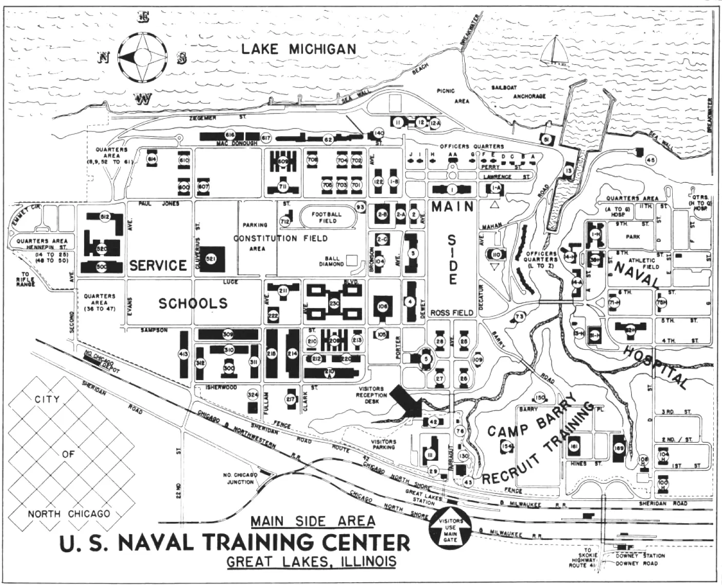
Click or tap the map to enlarge it.
Naval Station Great Lakes Map 1959 – Exploring History in Detail
Key Takeaways
- The Naval Station Great Lakes Map 1959 provides a detailed snapshot of the naval base during that period.
- The map showcases the extensive facilities and infrastructure within the station premises.
- It offers valuable insights into the naval training operations and the surrounding area.
- Naval Station Great Lakes holds historical significance as the United States Navy’s largest training center.
- Studying historical maps like this enables us to understand the development and importance of naval bases throughout history.
History of Naval Station Great Lakes
Naval Station Great Lakes, located in Lake County, Illinois, has a rich history dating back to its establishment in 1911. Originally intended to provide basic training for recruits, the station grew in scale and significance over the years. By the time the Naval Station Great Lakes Map of 1959 was created, it had become the largest training center for the United States Navy.
The base played a crucial role during both World Wars as it trained thousands of sailors to serve in the Navy. The map provides a glimpse into the facilities, training centers, and organizational structures present during this pivotal period.
Insights from the Naval Station Great Lakes Map 1959
The map provides a comprehensive overview of the station and its surrounding area. Some unique insights include:
1. Training Facilities
The map displays various training facilities such as boot camps, schools, and specialized training centers. These establishments were essential for training new recruits and honing the skills of existing sailors.
2. Infrastructure
Infrastructure played a crucial role in the functioning of Naval Station Great Lakes. The map highlights the presence of piers, dry docks, and shipbuilding facilities. This reflects the importance of the station as a hub for naval operations and maintenance.
3. Administration and Support Services
The map illustrates administrative and support services within the station. It shows the location of headquarters, medical facilities, recreational areas, and other amenities, indicating the focus on providing a conducive environment for training and living.
4. Geographic Context
By analyzing the map, we gain geographical insights into the area surrounding Naval Station Great Lakes. It reveals the proximity of the station to Lake Michigan and the presence of neighboring towns and cities, which were intricately linked to the base’s activities.
Table: Relevant Facts of Naval Station Great Lakes (1959)
| Fact | Description |
|---|---|
| Total Area | Over 1,628 acres |
| Recruit Training Command | The primary training center for enlisted sailors |
| Naval Hospital | A medical facility catering to the health needs of military personnel |
| Naval Base Exchange | A center for shopping and services for Navy personnel and their families |
| Training Camps and Schools | Offering specialized training in various naval career fields |
| Shipbuilding and Maintenance Facilities | Crucial infrastructure for naval operations and repairs |
Frequently Asked Questions (FAQ)
1. What is Naval Station Great Lakes?
Naval Station Great Lakes is the largest training center for the United States Navy. It provides basic training to recruits and offers specialized training in various fields.
2. When was Naval Station Great Lakes established?
The base was established in 1911, initially to provide basic training for Navy recruits.
3. Why is the Naval Station Great Lakes Map 1959 significant?
The map offers historical insights into the infrastructure, facilities, and training operations of the naval base during a crucial period in its history.
4. What is the size of Naval Station Great Lakes?
The base spans over 1,628 acres of land.
5. Can visitors access the Naval Station Great Lakes?
Access to the base is restricted to authorized personnel and official visitors. However, there are occasional public events and tours organized for civilians.
6. What kind of training does Naval Station Great Lakes offer?
The station provides a wide range of training, including basic military training, specialized technical training, and leadership development programs for enlisted sailors.
7. How can I learn more about Naval Station Great Lakes?
For more information, you can visit the official website of Naval Station Great Lakes or contact their Public Affairs Office for specific inquiries.