Ob River Basin Map
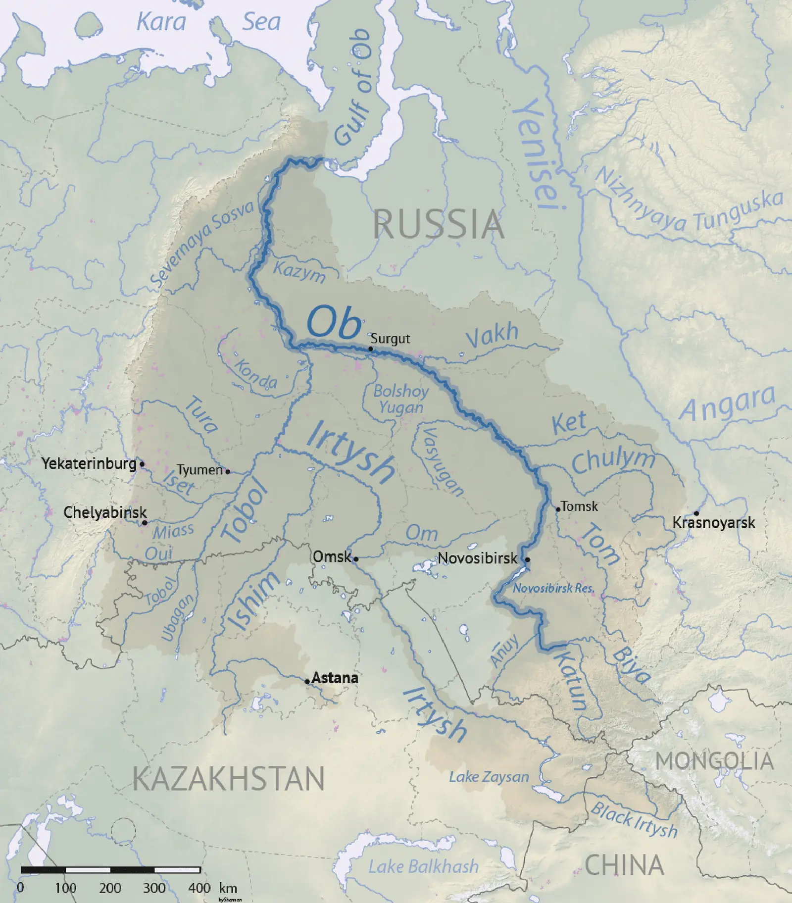
Click or tap the map to enlarge it.
Ob River Basin Map – An Expert Guide
Key Takeaways
- The Ob River Basin is one of the largest river systems in the world.
- The map showcases the geographical features, major cities, and important landmarks of the Ob River Basin.
- Understanding the map helps in comprehending the river’s flow, ecosystem, and its significance to the region.
History
The Ob River Basin, located in Western Siberia, Russia, has a rich history intertwined with the indigenous cultures and the exploration of the region. The map provides a visual representation of this historical significance.
The exploration of the Ob River Basin started in the late 16th century, with Russian explorer Yermak Timofeyevich leading the first official expedition in 1581. The map reflects the major trading outposts and Russian settlements established during this period.
In the 18th and 19th centuries, the Ob River Basin played a crucial role in the Russian fur trade industry. The map highlights the routes taken by fur traders, showcasing their influence on the region’s expansion and development.
During the Soviet era, the Ob River Basin became an important industrial region due to its abundant natural resources. The map demonstrates the locations of key industrial centers and how they impacted the economy.
Unique Insights
Studying the Ob River Basin map reveals interesting insights about the region:
- The Ob River, spanning over 3,650 kilometers, is one of the longest rivers in the world.
- The basin covers an area of approximately 2.9 million square kilometers, making it one of the largest river basins globally.
- A significant portion of the Ob River Basin lies within the Arctic Circle, influencing its unique climate and biodiversity.
Ob River Basin Map Facts
| Year | Event |
|---|---|
| 1581 | Yermak Timofeyevich leads the first official expedition to the Ob River Basin. |
| 18th – 19th centuries | The Ob River Basin becomes a major trading hub for the Russian fur industry. |
| 20th century | Industrialization transforms the Ob River Basin into an important economic region. |
FAQ
1. What is the importance of the Ob River Basin?
The Ob River Basin is of significant importance due to its vast size, role in transportation, ecosystem, and economic potential.
2. How long is the Ob River?
The Ob River stretches over 3,650 kilometers.
3. Are there any major cities located in the Ob River Basin?
Yes, several major cities like Novosibirsk, Omsk, and Barnaul are located within the basin.
4. Does the Ob River Basin have any unique flora and fauna?
Yes, the basin supports a diverse range of flora and fauna, including migratory bird species and large mammals like bears and reindeer.
5. Can you participate in recreational activities in the Ob River Basin?
Absolutely! The basin offers various recreational opportunities such as fishing, boating, and hiking for nature enthusiasts.
6. What is the climate of the Ob River Basin?
The Ob River Basin experiences a subarctic climate, characterized by long, cold winters and relatively short summers.
7. How has industrialization impacted the Ob River Basin?
Industrialization has led to both positive and negative impacts on the basin’s economy, infrastructure, and environment. It has contributed to economic growth but also raised concerns about pollution and ecosystem degradation.
External Links
LSI Keywords
- Ob River
- River Basin
- Western Siberia
- Exploration
- Fur trade
- Natural resources
- Arctic Circle
- Industrial centers
- Biodiversity
- Novosibirsk
- Omsk
- Barnaul
- Flora and fauna
- Recreational activities
- Subarctic climate
- Industrialization