Peleliu Map
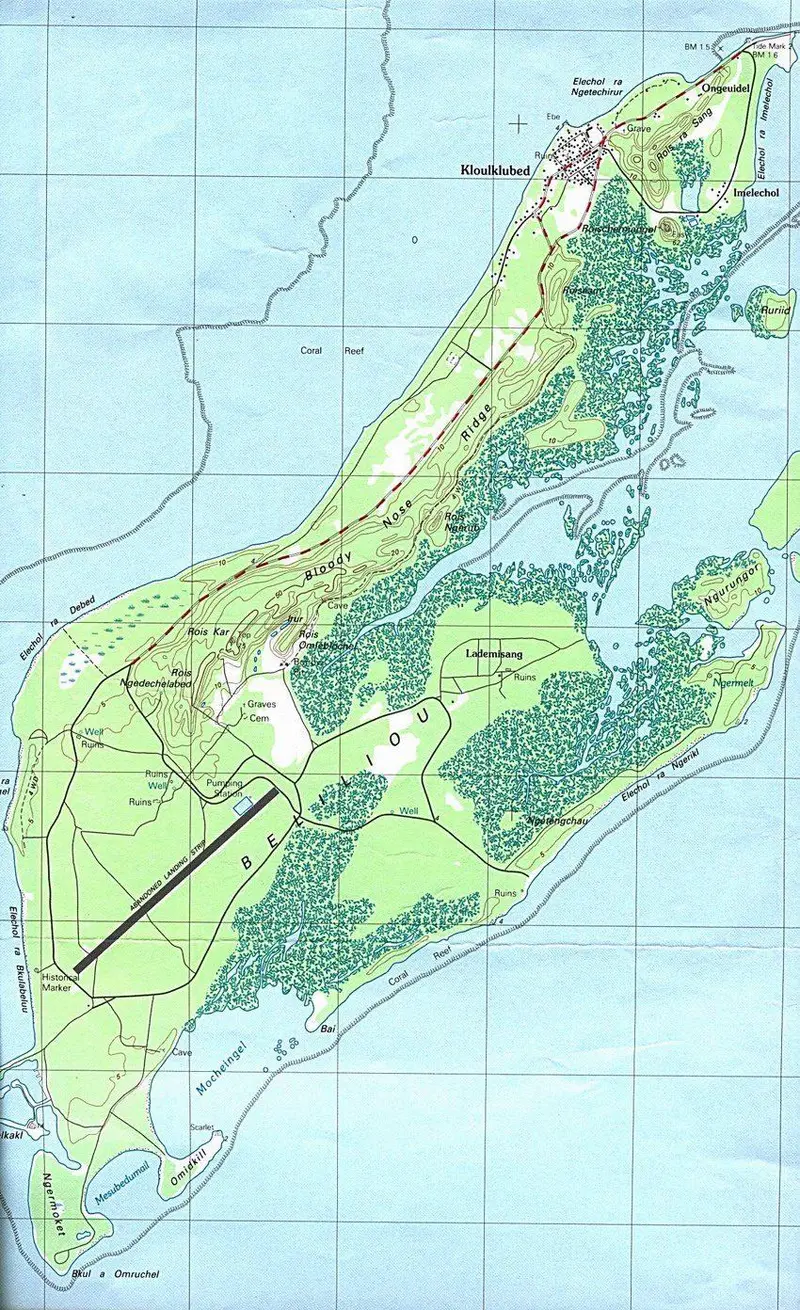
Click or tap the map to enlarge it.
Peleliu Map – An Expert Cartographer’s Guide
Key Takeaways
- The Peleliu Map provides a detailed representation of the island of Peleliu, showcasing its topography, landmarks, and historical significance.
- Cartographers meticulously design maps to aid navigation, understanding geographical features, and preserving historical information.
- The Peleliu Map is an invaluable resource for historians, researchers, and adventure enthusiasts exploring this Pacific island.
History
The Peleliu Map holds historical importance as it highlights the significant events that took place on the island during World War II. Peleliu is a small island located in the Pacific Ocean, part of Palau – an archipelago in Micronesia. In September 1944, the island became the focal point of a major battle between the United States and Japan.
The Battle of Peleliu was fought from September to November 1944 and aimed to capture the island from Japanese control. This battle was notable for its fierce resistance from Japanese forces, resulting in high casualty rates for both sides. The detailed depiction of Peleliu on the map helps to visualize the battleground, including key strategic points, such as Umurbrogol Mountain and Orange Beach.
Unique Insights
The Peleliu Map offers unique insights into the terrain and features of the island. It reveals the varying topography, ranging from sandy beaches to dense jungles and rugged cliffs. Cartographers have meticulously represented the island’s geography, enabling users to understand the challenges faced by soldiers during the battle.
Additionally, the map highlights landmarks that played crucial roles during the Battle of Peleliu. One significant feature is the Umurbrogol Mountain, often referred to as “Bloody Nose Ridge” due to the intense fighting that took place there. Understanding the geography and strategic importance of this mountain is facilitated through the detailed representation on the map.
Another unique insight provided by the Peleliu Map is the depiction of Orange Beach, one of the landing sites for the American forces. This insight allows for a better understanding of the initial assault and the logistical challenges faced during the battle.
Facts during the Battle of Peleliu
| Date | Event |
|---|---|
| September 15, 1944 | The United States initiates the invasion of Peleliu with the landing of the First Marine Regiment. |
| September 19, 1944 | Elements of the U.S. 81st Infantry Division land on Peleliu and relieve the marines. |
| September 23-27, 1944 | Heavy fighting occurs at Umurbrogol Mountain as U.S. forces attempt to dislodge Japanese troops. |
| November 27, 1944 | U.S. forces finally secure the island, with Japanese resistance ending. |
FAQ
1. Why is Peleliu Map important for historians?
The Peleliu Map is crucial for historians as it provides a visual representation of the battlefield during the Battle of Peleliu. It helps them analyze the strategic decisions, troop movements, and challenges faced during the conflict.
2. Can the Peleliu Map be used for hiking and exploration purposes?
Yes, the Peleliu Map is a valuable resource for adventure enthusiasts interested in hiking and exploring the island. It guides them through different terrains, landmarks, and historical sites, ensuring a comprehensive experience.
3. How accurate is the Peleliu Map in terms of the island’s current state?
The Peleliu Map accurately represents the terrain and geographic features of the island. However, there might be some changes to the landscape due to natural factors, erosion, or human development. It is advisable to consult other sources or local guides for the most up-to-date information.
4. Where can one obtain a physical copy of the Peleliu Map?
Physical copies of the Peleliu Map can be obtained from various sources. It is recommended to check with local bookstores, historical societies, or online platforms specializing in military history or maps.
5. How can the Peleliu Map aid in understanding the Battle of Peleliu?
The Peleliu Map offers detailed information about the island’s geography, key landmarks, and strategic points. By studying the map alongside historical accounts, it becomes easier to visualize the battle, tactics employed, and the immense challenges faced by both American and Japanese forces.
6. Are there any virtual versions of the Peleliu Map available online?
Yes, there are virtual versions of the Peleliu Map available online. Various websites, digital libraries, and research institutions offer access to high-resolution scans or interactive maps that allow users to explore the island virtually.
7. Can the Peleliu Map be utilized for educational purposes?
Absolutely! The Peleliu Map serves as a valuable educational resource. It helps students and educators better understand the historical context, geography, and significance of the Battle of Peleliu. It allows for engaging classroom discussions, projects, and presentations.