Political Map of Canada
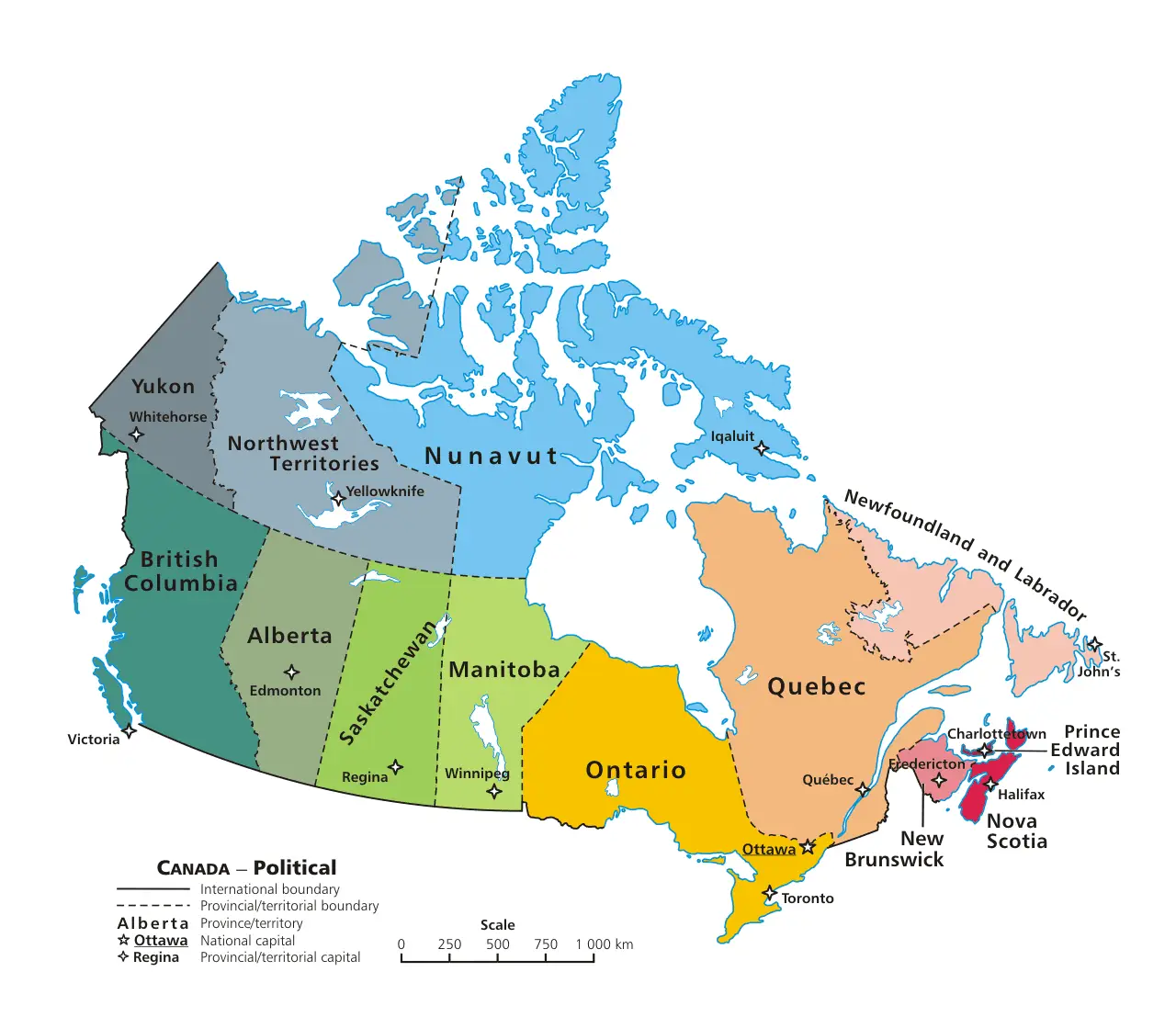
Click or tap the map to enlarge it.
Political Map Of Canada – A Detailed Overview
Key Takeaways
- Canada is the second-largest country in the world by land area.
- The map provides a comprehensive view of Canada’s political divisions, including provinces, territories, and major cities.
- It showcases the diverse geography and topography of Canada, from the rugged Rocky Mountains to the vast plains and the vast coastline.
- The map offers valuable information for travelers, researchers, and anyone interested in exploring Canada’s political landscape.
History
The political map of Canada reflects the country’s rich history and its evolution into the parliamentary democracy it is today. Canada, as a confederation, is composed of ten provinces and three territories, each with its own distinct identity and governance.
The process of political division in Canada began with the formation of provinces in the late 19th century. The Confederation of Canada, established in 1867, initially consisted of four provinces: Ontario, Quebec, New Brunswick, and Nova Scotia. Over time, additional provinces joined, including Manitoba, British Columbia, Prince Edward Island, Alberta, Saskatchewan, Newfoundland, and Labrador.
In the early 20th century, the Northwest Territories, Yukon, and Nunavut were established as territories, further expanding Canada’s political landscape. The political map of Canada has continued to evolve, with boundaries and divisions being adjusted periodically to reflect the changing needs and demographics of the country.
Today, Canada is known for its strong commitment to multiculturalism and diversity, which is reflected in the political representation of various provinces and territories within the confederation.
Unique Insights
The political map of Canada offers several unique insights into the country’s political landscape. Here are a few noteworthy observations:
1. Provincial Autonomy
Each province in Canada has a significant degree of autonomy in shaping its own laws, policies, and governance. This allows for localized decision-making and reflects the diverse needs and aspirations of the Canadian population.
2. Quebec’s Distinctiveness
Quebec, the predominantly French-speaking province, has a unique place within the political map of Canada. It has its own legal system, distinct cultural identity, and a history of advocating for its language and heritage preservation.
3. The Northern Territories
The territories of Canada, namely Yukon, Northwest Territories, and Nunavut, make up a significant portion of the country’s landmass. These sparsely populated regions have distinct challenges and opportunities, including resource extraction, indigenous cultures, and environmental conservation efforts.
4. Indigenous Representation
The political map of Canada acknowledges the importance of indigenous communities by preserving and recognizing their traditional lands. Several indigenous reserves and territories are indicated on the map, showcasing the country’s commitment to reconciliation and respect for First Nations, Inuit, and Métis peoples.
5. Urban Concentration
Major cities such as Toronto, Montreal, Vancouver, and Calgary hold significant political and economic influence within their respective provinces. They are often hubs of cultural exchange, innovation, and decision-making, shaping Canada’s political landscape at both the provincial and federal levels.
Relevant Facts
| Year | Key Event |
|---|---|
| 1867 | Confederation of Canada established with four provinces. |
| 1870 | Manitoba joins the confederation. |
| 1871 | British Columbia becomes a province. |
| 1905 | Alberta and Saskatchewan become provinces. |
| 1949 | Newfoundland and Labrador join the confederation. |
| 1999 | Nunavut is established as a territory, separating from the Northwest Territories. |
FAQ
1. How many provinces are there in Canada?
There are ten provinces in Canada.
2. What are the three territories in Canada?
The three territories in Canada are Yukon, Northwest Territories, and Nunavut.
3. Are the provinces and territories of Canada equal in terms of political power?
No, the provinces have more autonomy and decision-making powers compared to the territories.
4. Can provinces in Canada amend the constitution independently?
No, constitutional amendments require the consent of the federal government and a majority of provinces representing at least fifty percent of the population.
5. How are major cities represented politically?
Major cities have their own municipal governments and often play a significant role in decision-making at the provincial level.
6. Is Quebec the only French-speaking province in Canada?
No, New Brunswick is the only officially bilingual province in Canada, with a significant French-speaking population.
7. Are there any ongoing disputes regarding territorial boundaries?
In some cases, certain indigenous communities have land claims that are subject to ongoing negotiations with the federal and provincial governments.