Port Lincoln Location Map in South Australia
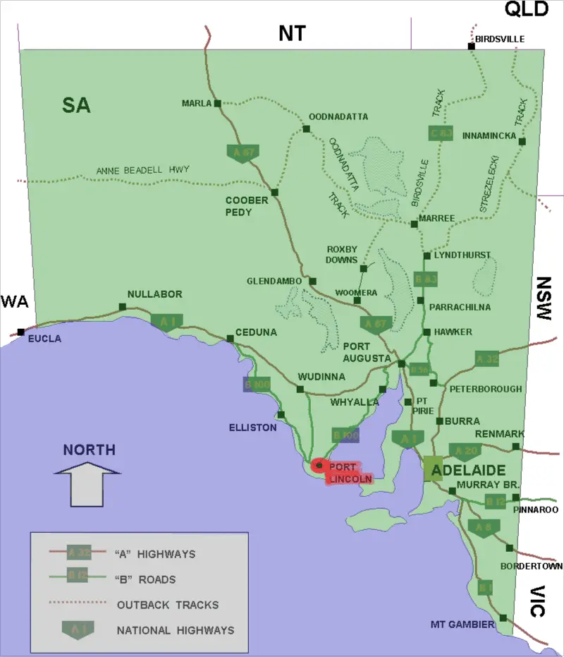
Click or tap the map to enlarge it.
Key Takeaways
- The Port Lincoln Location Map showcases the geography and positioning of Port Lincoln in South Australia.
- It provides a visual representation of the town’s location relative to surrounding areas and landmarks.
- Port Lincoln is located on the southern coast of the Eyre Peninsula and is known for its scenic beauty and thriving fishing industry.
History
Port Lincoln, located in South Australia, has a rich history that spans thousands of years. The region has been home to the Barngarla Aboriginal people for over 60,000 years. European settlement began in the early 19th century when Matthew Flinders explored the area in 1802 and named the bay after his native town, Lincoln, in England.
During the early years of settlement, the town evolved as a port for exporting agricultural and pastoral products from the surrounding areas. It played a vital role in the development of the Eyre Peninsula and became a significant hub for trade and transportation. The fishing industry also flourished, with Port Lincoln becoming known as the “Seafood Capital of Australia.”
Unique Insights
The Port Lincoln Location Map offers several unique insights:
- Geographical Position: The map showcases how Port Lincoln is situated on the southern coast of the Eyre Peninsula.
- Proximity to Natural Landscapes: It highlights the town’s close proximity to national parks, stunning beaches, and beautiful coastal landscapes, inviting visitors to explore the region’s natural beauty.
- Fishing Industry: The map emphasizes Port Lincoln’s significant role in the fishing industry, showcasing the town’s fishing fleet and processing facilities.
- Tourism Opportunities: With its exceptional seafood, breathtaking scenery, and opportunities for water-based activities, the map highlights Port Lincoln as a popular tourist destination.
Table of Relevant Facts
| Year | Event |
|---|---|
| 1802 | Matthew Flinders names the bay “Port Lincoln.” |
| 1853 | Port Lincoln officially established as a township. |
| 1909 | Construction of the Port Lincoln Jetty. |
| 1950s | Fishing industry experiences significant growth. |
| 1992 | Great White Shark cage diving becomes a popular tourist activity. |
FAQ
1. What makes Port Lincoln a popular tourist destination?
Port Lincoln offers a variety of attractions, including stunning beaches, national parks, vibrant marine life, and delicious seafood. It also provides opportunities for water-based activities such as fishing, boating, and shark cage diving, making it a must-visit destination for travelers.
2. How can I reach Port Lincoln?
Port Lincoln is accessible by air or road. The Port Lincoln Airport receives regular flights from Adelaide, and the Eyre Highway provides a scenic road trip option for those traveling by car.
3. Are there accommodations available in Port Lincoln?
Yes, Port Lincoln offers a range of accommodations, including hotels, motels, holiday apartments, and camping sites. Visitors can choose according to their preferences and budget.
4. What are some must-visit attractions in Port Lincoln?
Must-visit attractions in Port Lincoln include Lincoln National Park, Coffin Bay National Park, Winter Hill Lookout, and the Port Lincoln Wildlife Park.
5. Is Port Lincoln known for its fishing industry?
Yes, Port Lincoln is widely recognized as the “Seafood Capital of Australia” due to its thriving fishing industry. The town is known for its fresh and high-quality seafood, including tuna, abalone, and kingfish.
6. Can I go on a shark cage diving adventure in Port Lincoln?
Yes, shark cage diving is a popular activity in Port Lincoln, allowing adventurous individuals to witness great white sharks up close in their natural habitat.
7. What is the best time to visit Port Lincoln?
The best time to visit Port Lincoln is during the summer months (December to February) when the weather is warm and perfect for outdoor activities. However, the town is beautiful year-round, so anytime is a good time to explore its wonders.