Portland Downtown Map
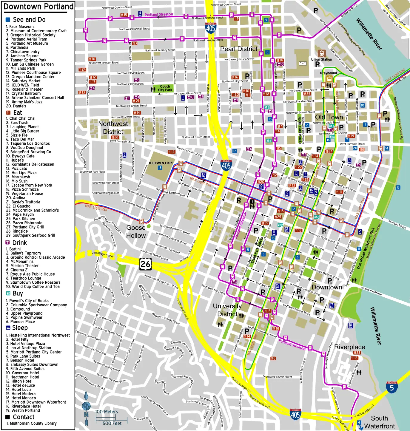
Click or tap the map to enlarge it.
Key Takeaways
- The Portland Downtown Map provides detailed information about the vibrant city and its landmarks.
- It offers valuable insights into the layout, attractions, and transportation options available in downtown Portland.
- This map is essential for tourists, residents, and businesses to navigate and explore the city effectively.
- By utilizing this map, visitors can easily locate popular destinations, such as museums, parks, restaurants, and shopping districts.
History of Portland
Early Settlement
Portland, situated in the state of Oregon, has a rich history dating back to its early settlement in the mid-19th century.
The city owes its name to the coin toss that decided its fate, with Francis W. Pettygrove from Portland, Maine, winning against Asa Lovejoy from Boston.
This event marked the beginning of Portland’s growth, positioning it as a major trading hub.
Great Fire of 1873
In 1873, Portland experienced a devastating fire that destroyed much of the downtown area.
Despite the setback, the city emerged stronger, swiftly rebuilding its infrastructure and transforming into a bustling metropolis.
This time, Portland implemented fire-safety regulations, leading to the development of brick buildings, which still dot the downtown landscape.
Expansion and Modernization
Throughout the following decades, Portland witnessed continual expansion and modernization.
The construction of bridges, like the iconic Hawthorne Bridge, improved connectivity within the city and facilitated further growth.
Additionally, advancements in transportation, such as the introduction of streetcars and later light rail systems, made commuting more convenient for residents and visitors.
Present-Day Portland
Today, Portland is renowned for its vibrant culture, environmentally friendly practices, and picturesque landscapes.
The downtown area, in particular, is a hub of activity, offering a diverse array of entertainment, shopping, and dining options.
The city’s commitment to sustainability is reflected in its numerous parks, bike paths, and pedestrian-friendly streets.
Portland’s unique blend of natural beauty and urban amenities continues to attract visitors from all over the world.
Unique Insights
The Portland Downtown Map goes beyond merely presenting street names and landmarks.
It provides valuable insights to help visitors make the most of their time in the city.
Here are a few unique insights offered by the map:
- Neighborhoods: The map highlights the distinct neighborhoods within downtown Portland, each offering its own charm and attractions. From the Pearl District’s art galleries to the historic architecture of Old Town Chinatown, visitors can explore the city’s diversity.
- Parks and Greenspaces: Portland is known as the “City of Roses” due to its numerous parks and gardens. The map identifies the location of these serene greenspaces, such as Tom McCall Waterfront Park and Pioneer Courthouse Square, inviting visitors to relax and enjoy nature.
- Food and Drink: Portland boasts a thriving food and beverage scene. The map showcases popular restaurants, cafes, and breweries, allowing visitors to savor the city’s renowned culinary offerings.
- Public Transportation: Understanding the public transportation system is crucial for navigating any city. The map provides clear information about bus routes, light rail stops, and streetcar lines, making it easier for tourists and residents to explore different parts of downtown Portland.
Relevant Facts Table
| Year | Event |
|---|---|
| 1843 | Settlement of Portland |
| 1873 | Great Fire of Portland |
| 1888 | Construction of the iconic Hawthorne Bridge |
| 1936 | Introduction of the first electric streetcar line |
| 1986 | Opening of the first light rail line |
Frequently Asked Questions (FAQ)
1. How can I obtain a copy of the Portland Downtown Map?
The Portland Downtown Map is readily available at various visitor centers, hotels, and online platforms. You can also find a digital version on the official Portland city website.
2. Are there any guided tours available based on the map?
Yes, numerous tour companies offer guided tours of downtown Portland based on the landmarks and attractions highlighted on the map. These tours provide in-depth insights into the city’s history and culture.
3. Does the map include bike lanes and cycling routes?
Absolutely! The Portland Downtown Map features designated bike lanes and cycling routes throughout the city. Portland is renowned for its bike-friendly infrastructure, and the map ensures cyclists can easily navigate and explore downtown.
4. What are some must-visit attractions identified on the map?
The map points out several must-visit attractions, including the Portland Art Museum, Powell’s City of Books, Voodoo Doughnut, and Lan Su Chinese Garden. These landmarks offer unique experiences that capture the essence of Portland.
5. Can I rely solely on the map for navigation?
While the Portland Downtown Map provides comprehensive guidance, it can be beneficial to use additional navigation tools. GPS-enabled devices and smartphone applications can assist with real-time directions and updates on traffic conditions.
6. Are there any maps specifically catering to public transportation?
Yes, in addition to the Portland Downtown Map, there are specific maps available that focus on the city’s public transportation system. These maps provide detailed information about bus routes, light rail lines, and streetcar stops to aid commuters.
7. Can I request a customized version of the map for my business?
Customized versions of the Portland Downtown Map can be obtained for specific businesses or events. Contact the Portland city authorities or consult with the map’s publishers for more information on customization options.