Ratnagiri District Map
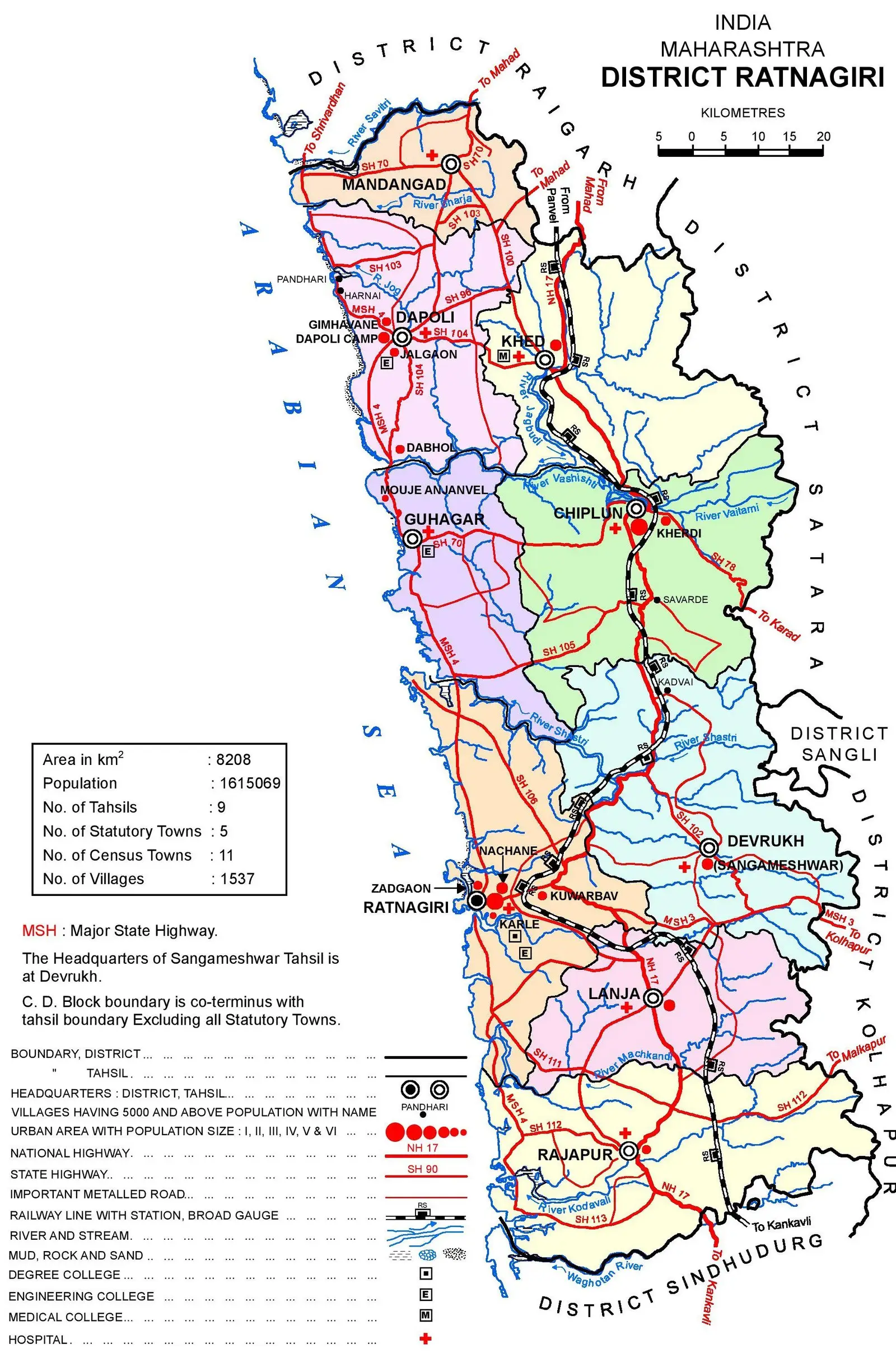
Click or tap the map to enlarge it.
Key Takeaways:
- Ratnagiri District, located in the state of Maharashtra, India, is known for its scenic beauty and rich historical heritage.
- The Ratnagiri District Map showcases the various towns, cities, rivers, and tourist attractions within the district.
- Exploring Ratnagiri through the map helps visitors plan their travel itineraries more effectively.
- The map also offers insights into the topographical features and important landmarks of the district.
- Understanding the Ratnagiri District Map is crucial for tourism, research, and general knowledge purposes.
History of Ratnagiri District:
Ratnagiri district has a rich historical background that dates back centuries. The district was once part of the Maurya Empire and later came under the control of several dynasties, including the Satavahanas, Rashtrakutas, and the Yadavas. Ratnagiri, the district’s headquarters, was an important trading port during ancient times and witnessed the influence of various civilizations, including the Portuguese and the British.
During the colonial era, Ratnagiri became a center of learning and progressive thinking. It is the birthplace of Lokmanya Tilak, a prominent freedom fighter and social reformer who played a key role in India’s struggle for independence. The district has several heritage sites, including forts, temples, and museums, that showcase its rich historical and cultural significance.
Insights from Ratnagiri District Map:
The Ratnagiri District Map offers several unique insights into the district’s geography, infrastructure, and tourist attractions. Here are some key insights:
1. Geographic Features:
The map highlights the district’s coastal location along the Arabian Sea. The coastline is dotted with beautiful beaches, picturesque hills, and lush green valleys, making Ratnagiri a popular tourist destination.
2. Towns and Cities:
The map identifies major towns and cities within Ratnagiri District, including Ratnagiri, Chiplun, Lanja, Guhagar, and Khed. These urban centers offer a mix of historical, cultural, and natural attractions for visitors to explore.
3. Rivers and Water Bodies:
The district is blessed with several rivers, including the Jagbudi, Vashishti, Savitri, and Shastri. These rivers not only add to the scenic beauty but also provide opportunities for water-based activities such as boating and river rafting.
4. Tourist Attractions:
The Ratnagiri District Map features popular tourist attractions like the Ratnadurg Fort, Ganpatipule Temple, Thibaw Point, Pawas, and the scenic beaches of Guhagar and Ganpatipule. These landmarks showcase the district’s historical significance, cultural heritage, and natural beauty.
5. Transportation Network:
The map displays roadways, railways, and other transportation routes within Ratnagiri District, enabling visitors to plan their travel itineraries more effectively. The Konkan Railway network runs through the district, offering picturesque train journeys along the coastline.
Table of Relevant Facts:
| Year | Event |
|---|---|
| 2nd century BCE | Ratnagiri under Maurya Empire |
| 6th-8th century CE | Ratnagiri ruled by the Chalukyas |
| 1500 CE | Portuguese occupation of Ratnagiri |
| 1818 CE | Ratnagiri comes under British rule |
| 1856 CE | Birth of Lokmanya Tilak in Ratnagiri |
Frequently Asked Questions (FAQ):
1. Is Ratnagiri District a popular tourist destination?
Yes, Ratnagiri District attracts a significant number of tourists due to its beautiful beaches, historical sites, and cultural heritage.
2. What are some must-visit attractions in Ratnagiri?
Some popular attractions in Ratnagiri include the Ratnadurg Fort, Ganpatipule Temple, Thibaw Point, Pawas, and the beaches of Guhagar and Ganpatipule.
3. Can I reach Ratnagiri by train?
Yes, Ratnagiri is well connected to major cities by rail. The Konkan Railway network passes through the district, offering scenic train routes.
4. Are there any historical landmarks in Ratnagiri?
Yes, Ratnagiri boasts several historical landmarks, including ancient forts, colonial-era buildings, and temples that reflect its rich historical background.
5. What is the best time to visit Ratnagiri?
The best time to visit Ratnagiri is during the winter season (October to March) when the weather is pleasant and ideal for sightseeing and outdoor activities.
6. Are there any adventure activities available in Ratnagiri?
Yes, Ratnagiri offers opportunities for adventure activities such as trekking, boating, and river rafting on the district’s rivers and hilly terrain.
7. Is Ratnagiri known for its cuisine?
Absolutely! Ratnagiri is famous for its seafood, especially the Alphonso mangoes, which are considered the best in India.