Regional Map of Maharashtra
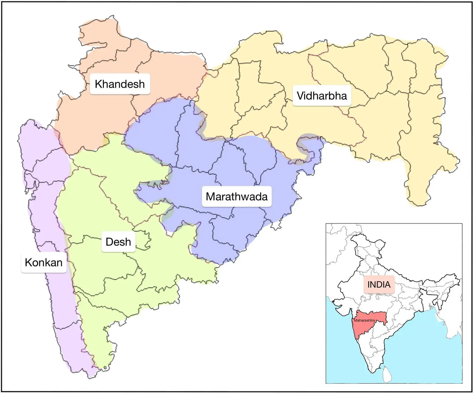
Click or tap the map to enlarge it.
Regional Map Of Maharashtra – A Comprehensive Guide
Key Takeaways
- Maharashtra is a diverse state in India, known for its rich culture and historical significance.
- The regional map of Maharashtra showcases the various districts and cities within the state.
- Exploring the map helps in understanding the geographical layout and highlights major landmarks and tourist attractions.
- It is a useful tool for tourists, researchers, and anyone interested in studying the region.
History
Maharashtra, located in the western part of India, has a long and fascinating history that dates back to ancient times. The region has witnessed the rise and fall of various empires and dynasties, leaving behind numerous historical landmarks and cultural heritage sites.
The Regional Map of Maharashtra provides a glimpse into this diverse state’s historical significance. From the ancient caves of Ajanta and Ellora to the magnificent forts of Raigad and Pratapgad, Maharashtra offers a captivating mix of architectural marvels and natural wonders.
Unique Insights
The Regional Map of Maharashtra not only helps in visualizing the state’s geographical layout but also offers unique insights into its regional diversity. Maharashtra is divided into six administrative divisions: Amravati, Aurangabad, Konkan, Nagpur, Nashik, and Pune.
The state boasts a remarkable contrast between the lush green mountains of the Western Ghats and the expansive plains of the Deccan plateau. The map clearly depicts the diverse regions, enabling an appreciation of the varying landscapes, climate, and cultural heritage of each area.
Table of Relevant Facts
| Year | Event |
|---|---|
| 1668 | The Marathas under Chhatrapati Shivaji Maharaj captured the fort of Raigad. |
| 1818 | The Third Anglo-Maratha War concluded with the defeat of the Marathas and the British East India Company’s control over Maharashtra. |
| 1857 | Maharashtra witnessed active participation in the Indian Rebellion against British colonial rule. |
| 1960 | Bombay State was divided into Maharashtra and Gujarat based on linguistic differences. |
FAQ
1. What are some must-visit attractions depicted on the Regional Map of Maharashtra?
Some notable attractions showcased on the map include the UNESCO World Heritage Sites of Ajanta and Ellora Caves, Gateway of India in Mumbai, Mahabaleshwar Hill Station, Shirdi Sai Baba Temple, and the Elephanta Caves.
2. How can the Regional Map of Maharashtra be utilized for research purposes?
Researchers can examine the map to analyze the distribution of various districts, geographical features, and historical landmarks. It can aid in studying the cultural, historical, and socio-economic aspects of different regions within Maharashtra.
3. What modes of transportation are available for exploring Maharashtra as shown on the map?
Maharashtra has a well-connected transportation network. The map highlights major highways, railways, airports, and waterways, providing travelers with options to explore the state conveniently.
4. Does the Regional Map of Maharashtra provide information on wildlife sanctuaries?
Yes, the map showcases national parks and wildlife sanctuaries such as Tadoba-Andhari Tiger Reserve, Tansa Wildlife Sanctuary, Bhimashankar Wildlife Sanctuary, and Melghat Tiger Reserve, giving an insight into Maharashtra’s rich biodiversity.
5. Is Marathi the only spoken language in Maharashtra?
While Marathi is the official language, Maharashtra is a multilingual state. The map represents the regional diversity by highlighting languages such as Hindi, Gujarati, Urdu, Telugu, Kannada, and many more spoken by various communities.
6. Can the Regional Map of Maharashtra be useful for planning a trip?
Absolutely! The map provides an overview of all the major tourist destinations, enabling travelers to plan their itinerary and explore the beauty and cultural heritage of Maharashtra efficiently.
7. Are there any famous festivals celebrated in Maharashtra?
Maharashtra is renowned for its grand celebrations of festivals like Ganesh Chaturthi, Diwali, Navaratri, and Gudhi Padwa. The map serves as a visual guide to identify regions where these festivals hold particular cultural significance.