Rough Political Map of Republic of Gilead
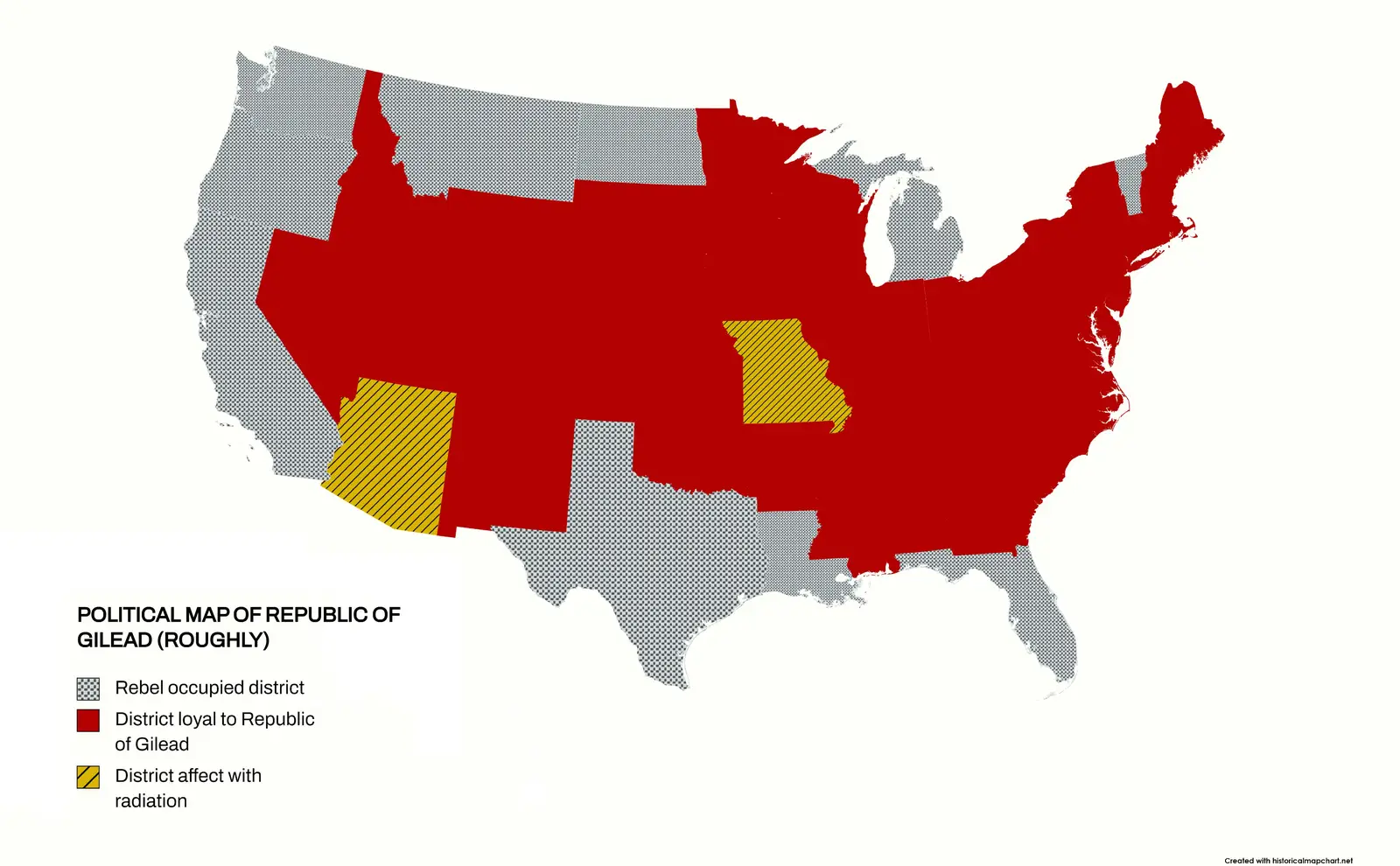
Click or tap the map to enlarge it.
Key Takeaways
- Rough Political Map Of Republic Of Gilead showcases the boundaries and divisions of the nation.
- The map depicts the unique political structure and territories within the Republic of Gilead.
- Understanding the geography of Gilead helps gain insights into the dynamics of the fictional world.
History
The Rough Political Map of Republic of Gilead is a visualization of the political divisions of the fictional nation
depicted in Margaret Atwood’s novel The Handmaid’s Tale. Set in a dystopian future, the book explores a
theocratic regime that has overthrown the United States government and established the Republic of Gilead.
The map showcases the different territories and political divisions within Gilead, offering a glimpse into the power
dynamics and control exerted by the ruling elite. While the novel does not provide a detailed description of the
Republic’s geography, this rough political map helps readers visualize the rough boundaries and regions of Gilead.
Unique Insights
By examining the Rough Political Map of Republic of Gilead, several unique insights can be gained:
- Political Structure: The map highlights the administrative subdivisions within Gilead, including
districts and provinces. This illustrates the centralized control of governance in the regime. - Geographical Features: Although not explicitly depicted in this rough map, understanding the
geography of Gilead can provide insights into the nation’s resources, access to water bodies, and potential
vulnerabilities. - Territorial Disputes: The map reveals areas where regional power struggles might arise, as
different factions fight for control over territories and resources. - Important Landmarks: While not explicitly marked, the map suggests the presence of significant
political and cultural landmarks within Gilead, possibly serving as centers of power or resistance. - Symbolic Divisions: The map’s political divisions might hold symbolic meanings, representing
social hierarchies, inequalities, or ideological differences within Gilead.
Table of Relevant Facts
| Event | Date |
|---|---|
| Overthrow of the US government | Unknown |
| Establishment of the Republic of Gilead | Unknown |
FAQ
1. What is the Republic of Gilead?
The Republic of Gilead is a fictional theocratic nation depicted in Margaret Atwood’s novel The Handmaid’s
Tale. It is characterized by strict social hierarchies and the oppression of women.
2. Is the Rough Political Map of Republic of Gilead official?
No, the Rough Political Map of Republic of Gilead is not an official map. It is a representation created to aid in
visualizing the political divisions within the fictional nation.
3. Are there any other maps available for Gilead?
There might be other maps available for Gilead, including more detailed or precise versions. The Rough Political Map
is a simplified representation.
4. Does the Rough Political Map of Gilead show physical features?
No, this map focuses solely on the political divisions and boundaries within the Republic of Gilead. It does not
depict physical features.
5. Are there any areas of resistance shown on the map?
The map does not explicitly mark areas of resistance. However, the presence of different territories suggests the
potential existence of resistance movements against the ruling regime.
6. Can I use this map as a reference for academic purposes?
While the Rough Political Map of Republic of Gilead can provide general insights, it is important to note that the
nation depicted is fictional. For academic purposes, referring to the original novel and scholarly sources is more
appropriate.
7. How accurate is the depiction of Gilead’s political divisions?
The accuracy of the map’s depiction is subjective, as it is based on interpretations of the novel. The author does
not provide precise details, leaving room for creative freedom in visualizing the political landscape of Gilead.