Saurashtra Region Within Gujarat India Relief Map
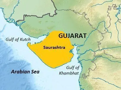
Click or tap the map to enlarge it.
Key Takeaways
- The Saurashtra region, located within Gujarat, India, offers diverse geographical features and cultural richness.
- Saurashtra is home to a unique relief map that showcases the terrain and topographic details of the region.
- Exploring this relief map can provide valuable insights into the physical characteristics of Saurashtra and its surrounding areas.
History of the Saurashtra Region
The Saurashtra region, also known as Kathiawar, has a rich history dating back several centuries. The name “Saurashtra” is derived from two Sanskrit words, “Saura” (Sun) and “Rashtra” (Region), which translates to “the region where the Sun shines.” This name reflects the sun-drenched landscapes and warm climate that prevail in this region.
Throughout history, Saurashtra has witnessed the rise and fall of various empires and dynasties. It has been ruled by the Maurya Empire, the Gupta Empire, and later by various Rajput dynasties. The region also played a significant role during the reign of the Chalukyas, Solankis, Mughals, and the British Raj.
Today, Saurashtra is a vibrant region with a blend of traditional and modern influences. Its cultural heritage, agricultural practices, and geographical features make it a unique and important part of Gujarat, India.
Unique Insights
The relief map of the Saurashtra region within Gujarat provides valuable insights into the topography and physical features of the area. It allows cartographers, researchers, and enthusiasts to study and understand the region in more detail. Here are some unique insights the map offers:
- The relief map showcases the various elevations and landforms within Saurashtra, including mountains, plateaus, and plains.
- It highlights the major rivers, lakes, and reservoirs present in the region, serving as lifelines for agriculture and water supply.
- The map identifies the national parks and wildlife sanctuaries in Saurashtra, indicating the rich biodiversity and conservation efforts in the area.
- It illustrates the road networks, railways, and transportation infrastructure, providing insights into the connectivity of the region.
- Through 3D visualizations, the map enables viewers to understand how the terrain changes from one area to another, showcasing the diversity of Saurashtra.
Table of Relevant Facts
| Time Period | Historical Event |
|---|---|
| 3rd Century BCE | Saurashtra region was part of the Maurya Empire. |
| 6th Century CE | Ruled by the Maitraka Dynasty. |
| 10th Century CE | Saurashtra witnessed the rise of the Chalukya Dynasty. |
| 15th Century CE | The Solanki Dynasty ruled over the region. |
| 18th Century CE | Saurashtra came under the control of the British East India Company. |
FAQs about the Saurashtra Region and its Relief Map
1. What is the importance of the Saurashtra region?
The Saurashtra region holds significant historical and cultural importance. It is known for its diverse geographical features and rich heritage.
2. What is a relief map?
A relief map is a topographic map that shows the physical features, elevations, and relief of a particular area. It provides a three-dimensional representation of the terrain.
3. What are the major rivers in Saurashtra?
Saurashtra is blessed with several rivers, including the Sabarmati, Bhadar, Machhu, and Shetrunji. These rivers play a crucial role in agriculture and water supply.
4. Are there any national parks in the Saurashtra region?
Yes, the Gir National Park, Blackbuck National Park, and Marine National Park are some of the prominent national parks in the Saurashtra region. These parks harbor diverse flora and fauna.
5. Is the relief map of Saurashtra available online?
Yes, the relief map of the Saurashtra region is available online. It can be accessed through various mapping platforms and websites dedicated to cartography.
6. Can the relief map be used for research purposes?
Absolutely! The relief map of Saurashtra provides valuable data and visual representations that are useful for researchers, academicians, and cartographers interested in studying the region’s physical characteristics.
7. How can the relief map benefit tourists visiting Saurashtra?
For tourists, the relief map of Saurashtra can serve as a helpful tool to plan their itineraries. It allows them to understand the terrain, identify major landmarks, and explore areas of specific interest.