Telangana State Map with Districts
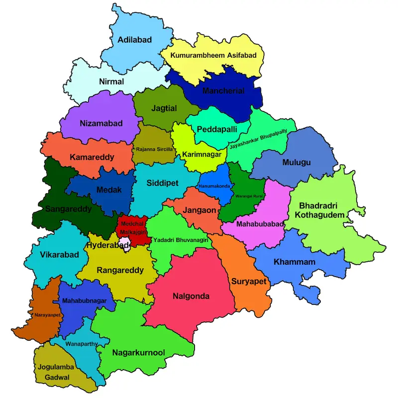
Click or tap the map to enlarge it.
Telangana State Map With Districts: Exploring the Dynamic Landscape
Key Takeaways
- Telangana is a state located in southern India.
- It was carved out of the state of Andhra Pradesh in 2014.
- The state is known for its rich cultural heritage and architectural wonders.
- Telangana comprises 33 districts, each with its unique charm and significance.
- The state map allows us to explore the diverse geography, historical landmarks, and natural beauty of Telangana.
History
Telangana, a region with a deep-rooted history, became the 29th state of India on June 2nd, 2014. The demand for a separate state arose out of the aspirations of the Telangana people, who felt the need for political, economic, and social empowerment.
This region, which was once a part of Andhra Pradesh, witnessed several movements and protests before the formation of the state. The Telangana Rebellion of 1946 and the Telangana Movement from 1969 to 1972 played a crucial role in shaping the identity and demands of the region.
Unique Insights
Exploring the Telangana state map reveals fascinating insights about its diverse geography and cultural heritage. Here are some unique features:
- Telangana is blessed with an abundance of natural resources, including rivers, lakes, and forests.
- The state is home to several wildlife sanctuaries and national parks, showcasing its commitment to environmental conservation.
- Hyderabad, the capital city of Telangana, is famous for its historical landmarks like the Charminar and Golconda Fort.
- Economically, Telangana is known for its thriving IT sector and industrial development.
- The state is also renowned for its rich cultural heritage, which is reflected in its arts, crafts, and festivals.
Telangana State Map: Facts and Figures
| Name | Area (sq. km) | Population |
|---|---|---|
| Adilabad | 16,129 | 2,743,497 |
| Bhadradri Kothagudem | 7,483 | 1,066,602 |
| Hyderabad | 217 | 9,700,000 |
| Jagtial | 2,879 | 986,629 |
| Kamareddy | 4,306 | 1,023,321 |
| Karimnagar | 11,823 | 1,005,711 |
| Khammam | 16,030 | 1,464,971 |
| Mahabubabad | 2,852 | 747,965 |
| Medak | 9,699 | 2,670,097 |
| Medchal | 3,690 | 1,841,622 |
| Nagarkurnool | 7,956 | 1,631,399 |
| Nalgonda | 14,240 | 3,488,809 |
| Nirmal | 3,845 | 709,418 |
| Nizamabad | 7,956 | 2,551,335 |
| Peddapalli | 2,751 | 799,180 |
| Rajanna Sircilla | 2,149 | 546,785 |
| Ranga Reddy | 7,493 | 5,296,741 |
| Sangareddy | 4,464 | 1,527,628 |
| Siddipet | 3,281 | 1,628,240 |
| Suryapet | 3,374 | 1,099,560 |
| Vikarabad | 3,386 | 1,464,358 |
| Wanaparthy | 2,477 | 688,723 |
| Warangal(R) | 12,846 | 3,512,576 |
| Warangal(U) | 2,175 | 766,681 |
| Yadadri Bhuvanagiri | 3,092 | 809,547 |
Frequently Asked Questions (FAQ)
1. How many districts are there in Telangana?
Telangana comprises a total of 33 districts.
2. When was Telangana formed as a separate state?
Telangana became a separate state on June 2nd, 2014.
3. What is the capital city of Telangana?
Hyderabad is the capital city of Telangana.
4. What are some popular tourist attractions in Telangana?
Some popular tourist attractions in Telangana include the Charminar, Golconda Fort, Ramappa Temple, Kakatiya Kala Thoranam, and Bhongir Fort.
5. What is the significance of Telangana’s cultural heritage?
Telangana’s cultural heritage is known for its unique art forms, such as the Telangana folk dance, Batik textiles, and Nirmal paintings.
6. Are there any wildlife sanctuaries in Telangana?
Yes, Telangana is home to several wildlife sanctuaries, including KBR National Park, Pakhal Wildlife Sanctuary, and Amrabad Tiger Reserve.
7. Does Telangana have any historical landmarks?
Absolutely! Telangana boasts historical landmarks like the Charminar, Golconda Fort, Thousand Pillar Temple, and Warangal Fort.