Toronto Subway Map
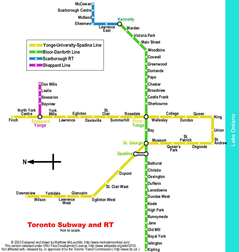
Click or tap the map to enlarge it.
Toronto Subway Map: A Comprehensive Guide
Key Takeaways
- The Toronto Subway Map is an essential navigation tool for locals and visitors alike.
- It consists of four major lines, serving the downtown core, suburbs, and airport.
- The subway network allows for efficient transportation across the Greater Toronto Area.
- TTC (Toronto Transit Commission) operates and maintains the subway system.
History
The Toronto Subway Map has a rich history that dates back to its inauguration on March 30, 1954.
Initially known as the “Yonge line,” it consisted of an 8.6 km stretch connecting Union Station and Eglinton Avenue.
Over the years, the subway system expanded to serve a larger area, and new lines were added to better serve growing populations.
The current map encompasses four major subway lines: Line 1 (Yonge-University), Line 2 (Bloor-Danforth), Line 3 (Scarborough), and Line 4 (Sheppard).
Unique Insights
The Toronto Subway Map offers a unique insight into the city’s transportation infrastructure.
Here are some interesting facts about its development and design:
- The first subway stations were designed in a modernist style, featuring clean lines and a vibrant use of colours.
- The iconic TTC logo, a red and white “T,” has been a symbol of the Toronto Subway since its inception.
- Line 2 is the longest subway line in Toronto, spanning a distance of 26.2 km.
- The subway system introduced automated fare collection in 2006, allowing for easier access and reduced ticketing issues.
Table of Relevant Facts
| Year | Event |
|---|---|
| 1954 | The Yonge line, the first subway line, opens to the public. |
| 1963 | The Bloor-Danforth line extends the subway network west to Keele Street and east to Woodbine Avenue. |
| 1985 | The Scarborough line opens, connecting Kennedy Station to McCowan Station. |
| 2002 | Line 4, also known as the Sheppard line, commences operations. |
Frequently Asked Questions (FAQ)
1. How far does Line 1 (Yonge-University) extend?
Line 1 extends from Vaughan Metropolitan Centre Station in the north to Finch Station in the northwest and Union Station in the south.
2. Are there any plans for further expansion?
Yes, the Toronto subway system is constantly evolving. There are ongoing discussions and plans for extending existing lines and building new ones to accommodate future growth.
3. Can I use the same fare card for buses and streetcars?
Yes, the Presto card can be used for fare payment across the TTC network, including buses, streetcars, and subways.
4. Does the subway network operate 24/7?
No, the subway operation hours are generally from approximately 6:00 a.m. to 1:30 a.m., depending on the day of the week.
5. Are there accessibility features available in the subway stations?
Yes, all new stations and most existing stations have accessibility features such as elevators and ramps to ensure accessibility for passengers with disabilities.
6. Are there any express or limited-stop services?
Yes, some subway trains offer express services during peak hours, which skip certain stations, allowing for faster commute times.
7. Are pets allowed on the subway?
Pets are allowed on the Toronto Subway; however, it is required that they be in an enclosed carrier.
External Links
LSI Keywords
- Toronto subway network
- Public transportation in Toronto
- TTC subway lines
- Subway maps and routes
- Toronto transportation history
- TTC fare collection
- Toronto subway expansion plans