Uptown New Orleans Map
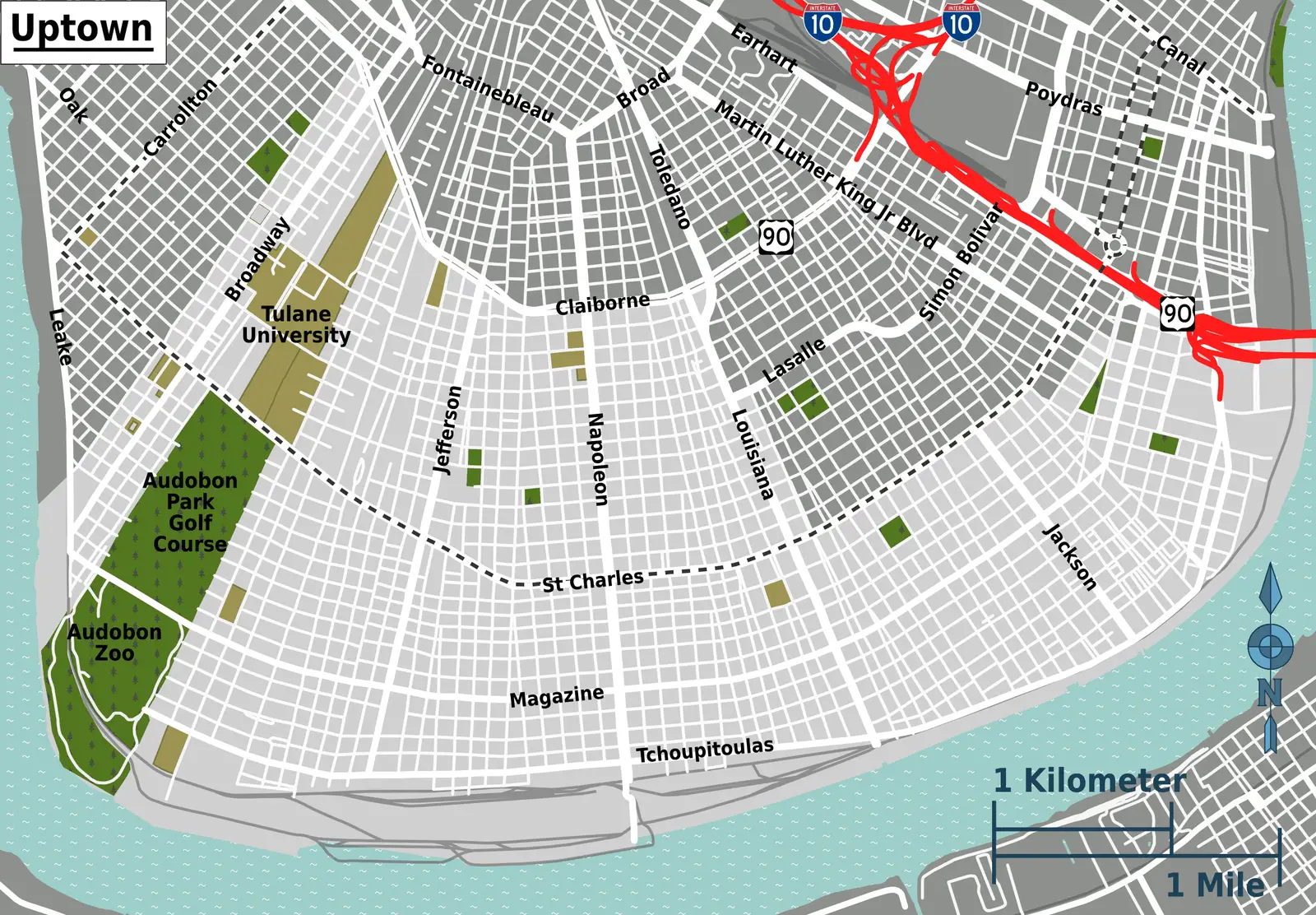
Click or tap the map to enlarge it.
Uptown New Orleans Map: Explore the Charming Neighborhood
Key Takeaways
- Uptown New Orleans is a vibrant and picturesque neighborhood known for its historic charm, beautiful architecture, and lively atmosphere.
- The Uptown area is home to famous landmarks such as Tulane and Loyola Universities, Audubon Park, Magazine Street, and the Garden District.
- Exploring this neighborhood is a delightful experience, with its eclectic mix of shops, restaurants, art galleries, and stunning tree-lined streets.
History of Uptown New Orleans
Uptown New Orleans, also referred to as the “Garden District,” is a neighborhood located upriver from the historic French Quarter. The area was first developed in the 19th century and quickly became a popular residential destination for wealthy Creole families.
The neighborhood’s charming and well-preserved architecture reflects its rich history. Uptown is known for its grand mansions, Greek Revival-style townhouses, and beautifully manicured gardens. Many of these historic homes have been carefully maintained and restored, giving visitors a sense of the area’s past.
With the expansion of New Orleans’ streetcar system in the late 1800s, Uptown became more accessible and saw a boom in population. Today, it continues to be a thriving and sought-after residential area, attracting both locals and tourists.
Unique Insights
- Uptown New Orleans is well-known for its vibrant music scene. Many famous musicians have emerged from this neighborhood, contributing to the city’s rich musical heritage.
- The St. Charles Avenue streetcar, which runs through Uptown, is the oldest continuously operating streetcar line in the world. It offers a charming and nostalgic way to explore the area.
- Audubon Park, located in Uptown, is a picturesque green space that spans over 350 acres. It features a golf course, walking trails, lagoons, and the Audubon Zoo.
Table of Relevant Facts
| Year | Event |
|---|---|
| 19th Century | Uptown development begins, attracting wealthy Creole families. |
| Late 1800s | Expansion of streetcar system enhances accessibility to Uptown. |
| Present | Uptown remains a thriving residential area and cultural hub. |
Frequently Asked Questions (FAQ)
1. What are some must-visit attractions in Uptown New Orleans?
A: Uptown offers a range of attractions, including Audubon Park, Garden District’s historic homes, Magazine Street’s shops, and more.
2. Is Uptown New Orleans considered safe for tourists?
A: Uptown New Orleans is generally considered safe. However, it’s always wise to take basic safety precautions and be aware of your surroundings.
3. Can you recommend some restaurants in Uptown?
A: Some popular restaurants in Uptown New Orleans include Commander’s Palace, Jacque-Imo’s, and Domilise’s Po-Boys.
4. How do I get around Uptown?
A: The St. Charles Avenue streetcar provides convenient transportation within Uptown. Ride-sharing services and biking are also popular options.
5. What is the best time to visit Uptown New Orleans?
A: Uptown New Orleans can be enjoyed year-round. The spring and fall seasons offer pleasant weather for exploring the neighborhood.
6. Are there any annual events or festivals in Uptown?
A: Yes, Uptown hosts several festivals throughout the year, including the Freret Street Festival and Po-Boy Festival.
7. Can I take a guided tour of Uptown New Orleans?
A: Yes, there are guided walking and bus tours available that provide insights into the history, architecture, and culture of Uptown.