World Map True Proportioned Continents Approximation with Comparison
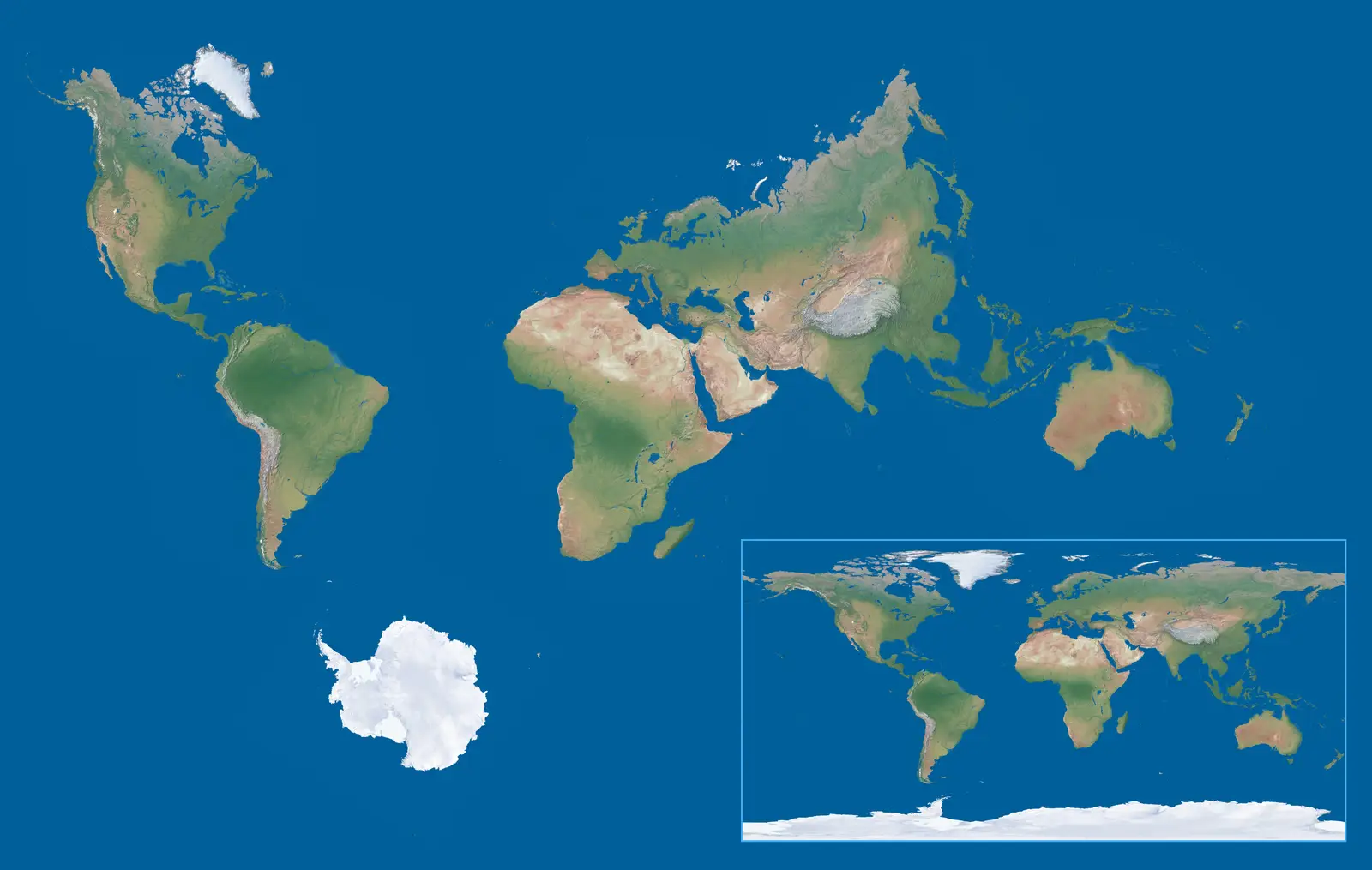
Click or tap the map to enlarge it.
Key Takeaways
- The World Map True Proportioned Continents Approximation With Comparison offers a more accurate representation of the Earth’s continents.
- It takes into account the distortions caused by the traditional Mercator projection.
- This map provides a clearer understanding of the relative sizes and shapes of the continents.
- It highlights the importance of using different projections to overcome biases and misconceptions.
- Understanding the world’s geography is essential for various purposes, including navigation, education, and international relations.
History
The World Map True Proportioned Continents Approximation With Comparison is a relatively new map that came into existence to address the limitations of traditional cartographic projections. Historically, maps have often used the Mercator projection, developed by the Flemish geographer Gerardus Mercator in 1569, for its ability to simplify navigational calculations. However, the Mercator projection distorts the sizes and shapes of continents as they get closer to the poles, making countries near the equator appear smaller than they are in reality.
With advancements in technology and better access to accurate geographical data, cartographers and geographers have recognized the need for more precise and balanced representations of the Earth’s continents. The World Map True Proportioned Continents Approximation With Comparison was developed to address these concerns by providing a more accurate depiction of the continents’ sizes and shapes.
Today, this map is valuable not only for geographical accuracy but also for challenging misconceptions and biases that arise from traditional map projections. It encourages people to think critically about how they perceive the world’s geography and highlights the importance of using different projections for different purposes.
Unique Insights
The World Map True Proportioned Continents Approximation With Comparison offers unique insights into the relative sizes of continents when compared to traditional map projections. The most notable insights include:
- True Sizes: Unlike the Mercator projection, this map accurately represents the true sizes of continents, allowing for a better understanding of their relative proportions.
- Less Distorted Shapes: This map minimizes distortions, allowing the shapes of continents to be closer to their actual form.
- Visual Contrast: By depicting the smaller size of some continents that are usually portrayed larger in traditional maps, this map brings awareness to the disproportionate emphasis placed on certain regions.
- Shifted Perspectives: The map challenges the dominance of northern countries in traditional cartography by presenting a more balanced view of the world where the southern regions are accurately represented.
Table of Relevant Facts
| Continent | Area (square kilometers) | Population (approx.) |
|---|---|---|
| Africa | 30,370,000 | 1,340,598,147 |
| Asia | 44,579,000 | 4,641,054,775 |
| Europe | 10,180,000 | 747,447,214 |
| North America | 24,709,000 | 579,024,000 |
| South America | 17,840,000 | 429,191,764 |
| Australia | 8,600,000 | 42,448,717 |
| Antarctica | 14,000,000 | N/A |
FAQ
-
Why is the World Map True Proportioned Continents Approximation important?
The map challenges the distortions and biases of traditional cartographic projections, providing a more accurate representation of continents for various purposes.
-
How does the World Map True Proportioned Continents Approximation achieve accuracy?
By using alternative projection techniques and incorporating precise geographical data, this map offers a more faithful portrayal of the Earth’s landmasses.
-
What are the practical applications of the World Map True Proportioned Continents Approximation?
It aids navigation, enhances spatial awareness, improves global education, and promotes a more inclusive and balanced perception of the world.
-
What are the limitations of the World Map True Proportioned Continents Approximation?
Like any map projection, it still has distortions due to the challenge of representing a three-dimensional object on a two-dimensional surface, but these distortions are minimized compared to other projections.
-
Which countries are most affected by traditional map distortions?
Countries near the poles, such as Greenland and Russia, appear much larger on traditional maps compared to their actual land area.
-
Can the World Map True Proportioned Continents Approximation be used for detailed regional analysis?
This map is better suited for gaining a global perspective. For detailed regional analysis, other specialized maps may be more appropriate.
-
Is the World Map True Proportioned Continents Approximation universally accepted?
While it has gained recognition and popularity among those interested in fairer map representations, it may take time for it to be fully embraced in all domains.